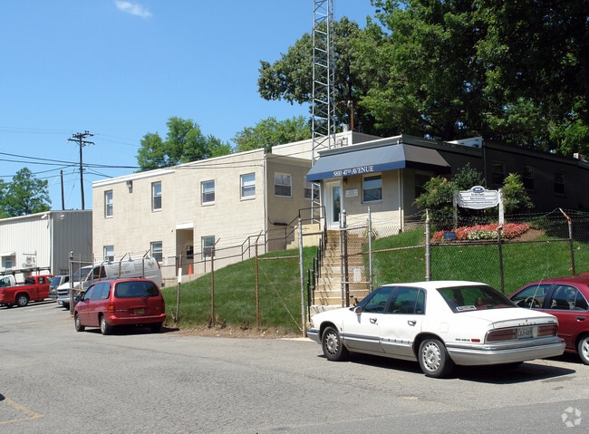
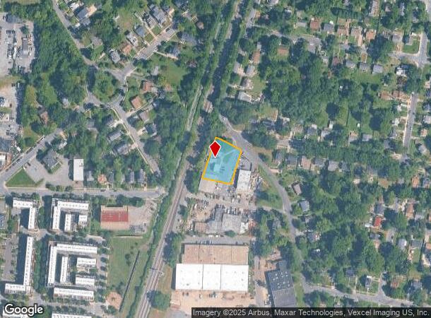
Property Record
5810 47Th Ave, Riverdale, MD 20737

Current Lease Availabilities
NEARBY LISTINGS FOR SALE OR LEASE
Property Detail
5810 47Th Ave
Washington-Arlington-Alexandria, DC-VA-MD-WV
Riverdale Park
19-2155679
RESUB PT LOT 1, PT LOT 2 LOT 3 EX 824 SQ FT
Officebuilding
Prince George's
X
Maryland
24033C0133E
1,2,3
2024
0.36 AC
2025
Cheverly/Hyattsville
806501
Washington, DC
9,438 SF
DEMOGRAPHICS near 5810 47Th Ave
1 mile
3 mile
5 mile
2024 Total Population
22,017
185,623
541,182
2029 Population
21,512
179,965
518,470
Pop Growth 2024-2029
(2.29%)
(3.05%)
(4.20%)
Average Age
37
36
37
2024 Total Households
7,096
58,982
190,748
HH Growth 2024-2029
(2.42%)
(3.43%)
(4.80%)
Median Household Inc
$95,581
$72,282
$73,640
Avg Household Size
3.00
2.90
2.70
2024 Avg HH Vehicles
2.00
2.00
1.00
Median Home Value
$454,962
$395,921
$426,990
Median Year Built
1957
1961
1961
Nearby Places
Map Layers
Map Styles
 Street
 Aerial
Transit
 Traffic
 Biking
Places
Listings with unknown addresses are not visible on the map
- Restaurants
- Banks
- Shops
- Fitness
- Groceries
PUBLIC TRANSPORTATION
TRANSIT/SUBWAY
Riverdale (Camden Line - Maryland Area Regional Commuter Trains (The MARC))
Drive
Walk
Distance
Riverdale (Camden Line - Maryland Area Regional Commuter Trains (The MARC))
2 min
9 min
0.4 mi
COMMUTER RAIL
Riverdale (Camden Line - Maryland Area Regional Commuter Trains (The MARC))
Drive
Walk
Distance
Riverdale (Camden Line - Maryland Area Regional Commuter Trains (The MARC))
2 min
9 min
0.5 mi
Drive
Walk
Distance
7 min
2.0 mi
AIRPORT
Ronald Reagan Washington Ntl
Drive
Walk
Distance
Ronald Reagan Washington Ntl
27 min
12.7 mi
Baltimore/Washington International Thurgood Marshall
Drive
Walk
Distance
Baltimore/Washington International Thurgood Marshall
39 min
24.6 mi
Washington Dulles International
Drive
Walk
Distance
Washington Dulles International
61 min
35.3 mi
Freight Ports
Port of Baltimore
Drive
Walk
Distance
Port of Baltimore
48 min
30.9 mi
Nearby Properties
Address
Land Use
TOTAL SIZE
Lot Size
Zoning
Address
Land Use
TOTAL SIZE
Lot Size
Zoning
2,043 SF
1,011.13 AC
RR
Address
Land Use
TOTAL SIZE
Lot Size
Zoning
2,985,682 SF
4.33 AC
RSF65
Address
Land Use
TOTAL SIZE
Lot Size
Zoning
639,347 SF
2.28 AC
RTOLE
Address
Land Use
TOTAL SIZE
Lot Size
Zoning
1,201,133 SF
41.56 AC
RTOHC
Address
Land Use
TOTAL SIZE
Lot Size
Zoning
398,693 SF
2.57 AC
LTOE
Address
Land Use
TOTAL SIZE
Lot Size
Zoning
74,664 SF
1.83 AC
RTOLE
Address
Land Use
TOTAL SIZE
Lot Size
Zoning
3.53 AC
RTOLE
Address
Land Use
TOTAL SIZE
Lot Size
Zoning
944,105 SF
23.09 AC
CGO
Address
Land Use
TOTAL SIZE
Lot Size
Zoning
330,003 SF
1.74 AC
RTOLE
Address
Land Use
TOTAL SIZE
Lot Size
Zoning
2.05 AC
RTOLE
Address
Land Use
TOTAL SIZE
Lot Size
Zoning
8,060 SF
1.63 AC
LTOE
Address
Land Use
TOTAL SIZE
Lot Size
Zoning
393,700 SF
1.30 AC
RTOLC
Address
Land Use
TOTAL SIZE
Lot Size
Zoning
3.64 AC
RTOHC
Address
Land Use
TOTAL SIZE
Lot Size
Zoning
578,232 SF
1.43 AC
RTOHC
Address
Land Use
TOTAL SIZE
Lot Size
Zoning
0.79 AC
RTOLE
Address
Land Use
TOTAL SIZE
Lot Size
Zoning
330,555 SF
2.12 AC
NAC
Address
Land Use
TOTAL SIZE
Lot Size
Zoning
337,500 SF
12.48 AC
RTOLE
Address
Land Use
TOTAL SIZE
Lot Size
Zoning
396 SF
6.80 AC
RTOHE
Address
Land Use
TOTAL SIZE
Lot Size
Zoning
9,184 SF
2.50 AC
LTOE
Address
Land Use
TOTAL SIZE
Lot Size
Zoning
395,538 SF
9.89 AC
RTOLE
Address
Land Use
TOTAL SIZE
Lot Size
Zoning
132,330 SF
3.20 AC
RTOLE
Address
Land Use
TOTAL SIZE
Lot Size
Zoning
230,000 SF
4.25 AC
MU-5A;RA-4
Address
Land Use
TOTAL SIZE
Lot Size
Zoning
309,374 SF
2.01 AC
RTOLE
Address
Land Use
TOTAL SIZE
Lot Size
Zoning
4.30 AC
RTOHE
Address
Land Use
TOTAL SIZE
Lot Size
Zoning
190,067 SF
0.72 AC
LTOE
Address
Land Use
TOTAL SIZE
Lot Size
Zoning
5.58 AC
RTOLC
Address
Land Use
TOTAL SIZE
Lot Size
Zoning
2.42 AC
RTOHC
Address
Land Use
TOTAL SIZE
Lot Size
Zoning
43,382 SF
2.18 AC
Address
Land Use
TOTAL SIZE
Lot Size
Zoning
256 SF
2.54 AC
LTOC
Address
Land Use
TOTAL SIZE
Lot Size
Zoning
106,729 SF
13.39 AC
R-1B
The World's #1 Commercial Real Estate Marketplace
Connect with us
© 2026 CoStar Group
The information above has been obtained from sources believed reliable. While we do not doubt its accuracy we have not verified it and make no guarantee, warranty or representation about it. It is your responsibility to independently confirm its accuracy and completeness. Any projections, opinions, assumptions, or estimates used are for example only and do not represent the current or future performance of the property. The value of this transaction to you depends on tax and other factors which should be evaluated by your tax, financial, and legal advisors. You and your advisors should conduct a careful, independent investigation of the property to determine to your satisfaction the suitability of the property for your needs.