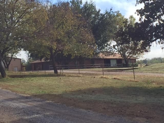
Property Record
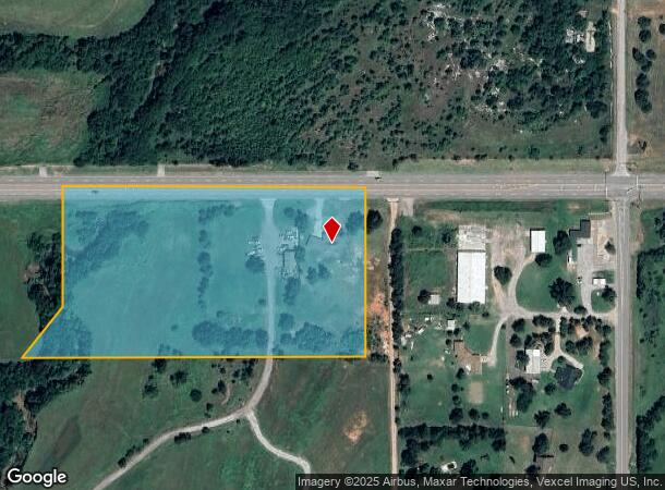
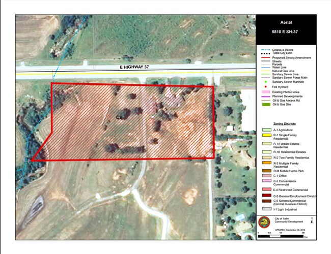
5810 E Highway 37, Tuttle, OK 73089
NEARBY LISTINGS FOR SALE OR LEASE
-
-
View all Tuttle listings for sale on LoopNet.com
Property Detail
5810 E Highway 37
0000-03-09N-05W-1-002-00
03-09-05-00100 COMM AT THE NE/C;TH S 89 55' 19"W ALONG THE N LINE OF SAID NE/4 690.00' TO THEPOB; TH S 00 11' 52" W 350'; TH S89 55' 19" W 860.00'; T H N 00 11'52" E 350.00' TO A POINT ON THE N. LINE; TH N 89 55' 19" E 860.00' TO THE POB LESS THE RIG
Storebuilding
Grady
AE
Oklahoma
40051C0140E
10.05 AC
2024
Grady County
2025
Oklahoma City
000904
Oklahoma City, OK
3,512 SF
DEMOGRAPHICS near 5810 E Highway 37
1 mile
3 mile
5 mile
2024 Total Population
1,348
8,448
17,916
2029 Population
1,456
9,151
19,850
Pop Growth 2024-2029
+ 8.01%
+ 8.32%
+ 10.79%
Average Age
43
42
41
2024 Total Households
497
3,049
6,339
HH Growth 2024-2029
+ 8.05%
+ 8.33%
+ 10.85%
Median Household Inc
$87,840
$95,183
$92,641
Avg Household Size
2.70
2.70
2.80
2024 Avg HH Vehicles
3.00
3.00
3.00
Median Home Value
$235,511
$245,375
$244,430
Median Year Built
1993
1995
1999
Nearby Places
Map Layers
Map Styles
 Street
 Aerial
Transit
 Traffic
 Biking
Places
Listings with unknown addresses are not visible on the map
- Restaurants
- Banks
- Shops
- Fitness
- Groceries
PUBLIC TRANSPORTATION
AIRPORT
Will Rogers World
Drive
Walk
Distance
Will Rogers World
28 min
17.3 mi
Freight Ports
Tulsa Port Of Catoosa
Drive
Walk
Distance
Tulsa Port Of Catoosa
161 min
145.4 mi
SALE & LEASE HISTORY
LISTING DATE
SALE/LEASE

Apr 03, 2017
For Sale
Nearby Properties
Address
Land Use
TOTAL SIZE
Lot Size
Zoning
Address
Land Use
TOTAL SIZE
Lot Size
Zoning
5,152 SF
6.99 AC
Address
Land Use
TOTAL SIZE
Lot Size
Zoning
3,996 SF
2.03 AC
Address
Land Use
TOTAL SIZE
Lot Size
Zoning
14,120 SF
6.63 AC
Address
Land Use
TOTAL SIZE
Lot Size
Zoning
3,410 SF
1.81 AC
Address
Land Use
TOTAL SIZE
Lot Size
Zoning
8,042 SF
1.63 AC
Address
Land Use
TOTAL SIZE
Lot Size
Zoning
4,155 SF
1.49 AC
Address
Land Use
TOTAL SIZE
Lot Size
Zoning
6,392 SF
45.45 AC
IP
Address
Land Use
TOTAL SIZE
Lot Size
Zoning
5,550 SF
1.37 AC
Address
Land Use
TOTAL SIZE
Lot Size
Zoning
9,165 SF
1.97 AC
Address
Land Use
TOTAL SIZE
Lot Size
Zoning
6,251 SF
5.01 AC
Address
Land Use
TOTAL SIZE
Lot Size
Zoning
400 SF
3.35 AC
Address
Land Use
TOTAL SIZE
Lot Size
Zoning
3,898 SF
25.16 AC
IP
Address
Land Use
TOTAL SIZE
Lot Size
Zoning
8,500 SF
5 AC
NP
Address
Land Use
TOTAL SIZE
Lot Size
Zoning
4,624 SF
6 AC
Address
Land Use
TOTAL SIZE
Lot Size
Zoning
3,900 SF
3 AC
Address
Land Use
TOTAL SIZE
Lot Size
Zoning
9,238 SF
1.43 AC
Address
Land Use
TOTAL SIZE
Lot Size
Zoning
5,659 SF
2.16 AC
Address
Land Use
TOTAL SIZE
Lot Size
Zoning
900 SF
1.48 AC
Address
Land Use
TOTAL SIZE
Lot Size
Zoning
7,150 SF
18.50 AC
CR
Address
Land Use
TOTAL SIZE
Lot Size
Zoning
4,299 SF
2.07 AC
Address
Land Use
TOTAL SIZE
Lot Size
Zoning
192 SF
2.09 AC
Address
Land Use
TOTAL SIZE
Lot Size
Zoning
3,171 SF
5 AC
Address
Land Use
TOTAL SIZE
Lot Size
Zoning
952 SF
3.54 AC
Address
Land Use
TOTAL SIZE
Lot Size
Zoning
5,358 SF
2.61 AC
Address
Land Use
TOTAL SIZE
Lot Size
Zoning
5,469 SF
11.74 AC
Address
Land Use
TOTAL SIZE
Lot Size
Zoning
4,636 SF
3 AC
Address
Land Use
TOTAL SIZE
Lot Size
Zoning
5,204 SF
1.53 AC
Address
Land Use
TOTAL SIZE
Lot Size
Zoning
4,773 SF
1.80 AC
Address
Land Use
TOTAL SIZE
Lot Size
Zoning
3,101 SF
9.64 AC
NP
Address
Land Use
TOTAL SIZE
Lot Size
Zoning
3,364 SF
0.86 AC
The World's #1 Commercial Real Estate Marketplace
Connect with us
© 2026 CoStar Group
The information above has been obtained from sources believed reliable. While we do not doubt its accuracy we have not verified it and make no guarantee, warranty or representation about it. It is your responsibility to independently confirm its accuracy and completeness. Any projections, opinions, assumptions, or estimates used are for example only and do not represent the current or future performance of the property. The value of this transaction to you depends on tax and other factors which should be evaluated by your tax, financial, and legal advisors. You and your advisors should conduct a careful, independent investigation of the property to determine to your satisfaction the suitability of the property for your needs.