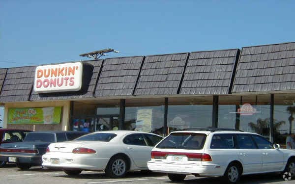
Property Record
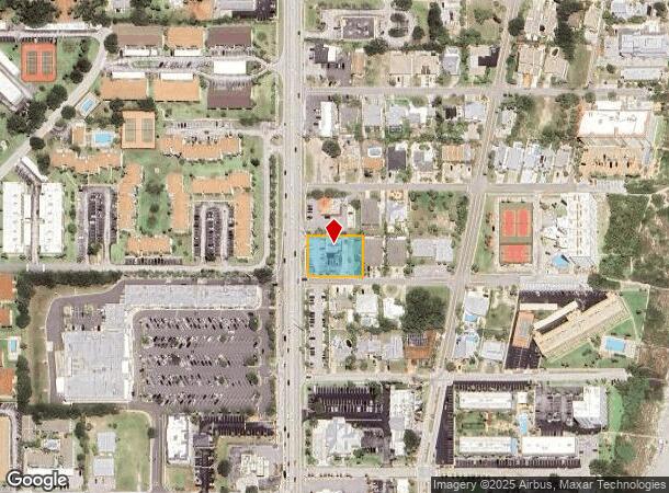
5810 N Atlantic Ave, Cocoa Beach, FL 32931
NEARBY LISTINGS FOR SALE OR LEASE
Property Detail
5810 N Atlantic Ave
Palm Bay-Melbourne-Titusville, FL
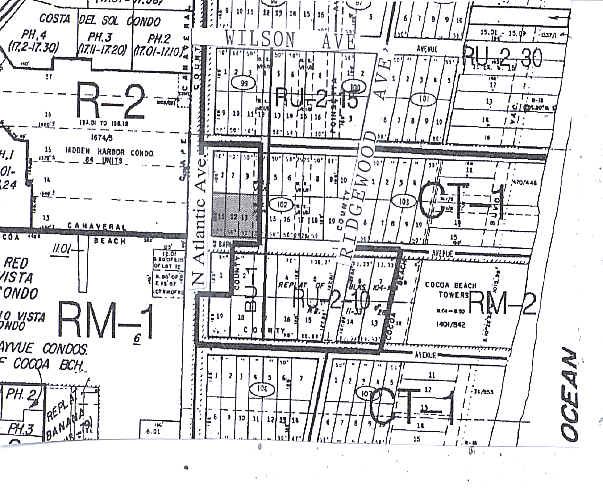
Avon By The Sea
24-37-26-CG-00102.0-0011.00
AVON BY THE SEA LOTS 11, 12 & 13 AND W 1/2 OF LOT 14 BLK 102
Restaurantdrivein
Brevard
X
Florida
12009C0451H
11
2024
0.50 AC
2025
Brevard County
068501
Orlando
2,428 SF
DEMOGRAPHICS near 5810 N Atlantic Ave
1 Mile
3 Mile
5 Mile
2024 Total Population
6,667
25,184
41,715
2029 Population
7,616
28,894
47,093
Pop Growth 2024-2029
+ 14.23%
+ 14.73%
+ 12.89%
Average Age
54
56
53
2024 Total Households
3,810
14,464
22,475
HH Growth 2024-2029
+ 14.12%
+ 14.71%
+ 13.13%
Median Household Inc
$73,787
$68,873
$72,514
Avg Household Size
1.80
1.70
1.80
2024 Avg HH Vehicles
2.00
1.00
2.00
Median Home Value
$378,713
$371,479
$368,877
Median Year Built
1976
1982
1980
Nearby Places
Map Layers
Map Styles
 Street
 Aerial
- Restaurants
- Banks
- Shops
- Fitness
- Groceries
PUBLIC TRANSPORTATION
AIRPORT
Melbourne Orlando International
DRIVE
WALK
Distance
Melbourne Orlando International
49 min
23.5 mi
Freight Ports
Port Canaveral
DRIVE
WALK
Distance
Port Canaveral
7 min
3.0 mi
Nearby Properties
Address
Land Use
TOTAL SIZE
Lot Size
Zoning
Address
Land Use
TOTAL SIZE
Lot Size
Zoning
211,222 SF
149.12 AC
Address
Land Use
TOTAL SIZE
Lot Size
Zoning
320,279 SF
51.92 AC
PS1
Address
Land Use
TOTAL SIZE
Lot Size
Zoning
127,650 SF
8.38 AC
Address
Land Use
TOTAL SIZE
Lot Size
Zoning
111,995 SF
7.23 AC
CT1
Address
Land Use
TOTAL SIZE
Lot Size
Zoning
195,045 SF
7.05 AC
CT1
Address
Land Use
TOTAL SIZE
Lot Size
Zoning
126,317 SF
6.23 AC
C1
Address
Land Use
TOTAL SIZE
Lot Size
Zoning
157,523 SF
6.90 AC
C1
Address
Land Use
TOTAL SIZE
Lot Size
Zoning
115,442 SF
3 AC
C2
Address
Land Use
TOTAL SIZE
Lot Size
Zoning
109,762 SF
3.32 AC
C1
Address
Land Use
TOTAL SIZE
Lot Size
Zoning
222,527 SF
9.55 AC
C1
Address
Land Use
TOTAL SIZE
Lot Size
Zoning
195,210 SF
10.99 AC
R3
Address
Land Use
TOTAL SIZE
Lot Size
Zoning
107,898 SF
3.41 AC
Address
Land Use
TOTAL SIZE
Lot Size
Zoning
28.30 AC
B1
Address
Land Use
TOTAL SIZE
Lot Size
Zoning
164,552 SF
3.82 AC
R2
Address
Land Use
TOTAL SIZE
Lot Size
Zoning
122,077 SF
4.33 AC
CT1
Address
Land Use
TOTAL SIZE
Lot Size
Zoning
81,694 SF
5.01 AC
C1
Address
Land Use
TOTAL SIZE
Lot Size
Zoning
95,520 SF
4.69 AC
C1
Address
Land Use
TOTAL SIZE
Lot Size
Zoning
111,708 SF
5.55 AC
CN
Address
Land Use
TOTAL SIZE
Lot Size
Zoning
100,707 SF
1.87 AC
CG
Address
Land Use
TOTAL SIZE
Lot Size
Zoning
83,746 SF
15.11 AC
RM1
Address
Land Use
TOTAL SIZE
Lot Size
Zoning
78,379 SF
12.68 AC
R3
Address
Land Use
TOTAL SIZE
Lot Size
Zoning
166,317 SF
12.44 AC
C2
Address
Land Use
TOTAL SIZE
Lot Size
Zoning
125,594 SF
3.20 AC
CT1
Address
Land Use
TOTAL SIZE
Lot Size
Zoning
103,220 SF
4.88 AC
RM2
Address
Land Use
TOTAL SIZE
Lot Size
Zoning
80,222 SF
5.51 AC
C2
Address
Land Use
TOTAL SIZE
Lot Size
Zoning
75,326 SF
8.33 AC
CN
Address
Land Use
TOTAL SIZE
Lot Size
Zoning
126,725 SF
11.03 AC
Address
Land Use
TOTAL SIZE
Lot Size
Zoning
70,330 SF
4.21 AC
CT1
Address
Land Use
TOTAL SIZE
Lot Size
Zoning
81,763 SF
8.54 AC
CN
Address
Land Use
TOTAL SIZE
Lot Size
Zoning
69,068 SF
6.10 AC
The World's #1 Commercial Real Estate Marketplace
Connect with us
© 2025 CoStar Group
The information above has been obtained from sources believed reliable. While we do not doubt its accuracy we have not verified it and make no guarantee, warranty or representation about it. It is your responsibility to independently confirm its accuracy and completeness. Any projections, opinions, assumptions, or estimates used are for example only and do not represent the current or future performance of the property. The value of this transaction to you depends on tax and other factors which should be evaluated by your tax, financial, and legal advisors. You and your advisors should conduct a careful, independent investigation of the property to determine to your satisfaction the suitability of the property for your needs.