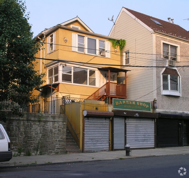
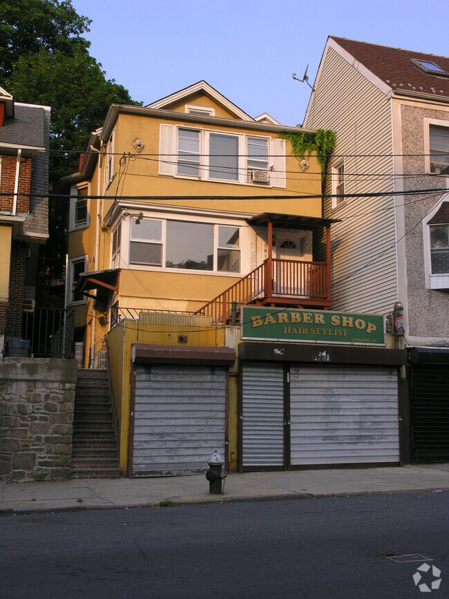
Property Record
5812 Mosholu Ave, Bronx, NY 10471


NEARBY LISTINGS FOR SALE OR LEASE
Property Detail
5812 Mosholu Ave
05851-2088
Map Of Property Of Sheridan & Seagrave
Commercialofficeresidentialmixeduse
Bronx
X
New York
34003C0220H
2088
2024
0.06 AC
2025
Bronx
034500
Westchester/So Connecticut
2,714 SF
New York-Jersey City-White Plains, NY-NJ
DEMOGRAPHICS near 5812 Mosholu Ave
1 mile
3 mile
5 mile
2024 Total Population
42,117
493,816
1,366,055
2029 Population
40,341
465,556
1,284,329
Pop Growth 2024-2029
(4.22%)
(5.72%)
(5.98%)
Average Age
41
39
39
2024 Total Households
15,656
182,338
497,412
HH Growth 2024-2029
(4.72%)
(6.19%)
(6.43%)
Median Household Inc
$79,221
$54,512
$54,046
Avg Household Size
2.40
2.60
2.60
2024 Avg HH Vehicles
1.00
1.00
1.00
Median Home Value
$413,055
$466,136
$495,917
Median Year Built
1954
1949
1950
Nearby Places
Map Layers
Map Styles
 Street
 Aerial
Transit
 Traffic
 Biking
Places
Listings with unknown addresses are not visible on the map
- Restaurants
- Banks
- Shops
- Fitness
- Groceries
PUBLIC TRANSPORTATION
COMMUTER RAIL
Riverdale Station (Hudson Line - Metro-North Commuter Railroad Company (Metro-North))
Drive
Walk
Distance
Riverdale Station (Hudson Line - Metro-North Commuter Railroad Company (Metro-North))
4 min
1.1 mi
Ludlow Station (Hudson Line - Metro-North Commuter Railroad Company (Metro-North))
Drive
Walk
Distance
Ludlow Station (Hudson Line - Metro-North Commuter Railroad Company (Metro-North))
4 min
1.9 mi
AIRPORT
LaGuardia
Drive
Walk
Distance
LaGuardia
24 min
13.4 mi
Westchester County
Drive
Walk
Distance
Westchester County
33 min
21.7 mi
John F Kennedy International
Drive
Walk
Distance
John F Kennedy International
38 min
23.2 mi
Freight Ports
NY - Red Hook Container Terminal
Drive
Walk
Distance
NY - Red Hook Container Terminal
37 min
18.9 mi
Nearby Properties
Address
Land Use
TOTAL SIZE
Lot Size
Zoning
Address
Land Use
TOTAL SIZE
Lot Size
Zoning
1,299,700 SF
29.82 AC
R6
Address
Land Use
TOTAL SIZE
Lot Size
Zoning
111.37 AC
P1
Address
Land Use
TOTAL SIZE
Lot Size
Zoning
72 AC
P1
Address
Land Use
TOTAL SIZE
Lot Size
Zoning
481,172 SF
205.58 AC
PARK
Address
Land Use
TOTAL SIZE
Lot Size
Zoning
895,256 SF
8.32 AC
R7-1
Address
Land Use
TOTAL SIZE
Lot Size
Zoning
1,237,424 SF
21.25 AC
R6
Address
Land Use
TOTAL SIZE
Lot Size
Zoning
219.71 AC
O
Address
Land Use
TOTAL SIZE
Lot Size
Zoning
204,200 SF
1.68 AC
R7-1
Address
Land Use
TOTAL SIZE
Lot Size
Zoning
100,151 SF
22.13 AC
B2
Address
Land Use
TOTAL SIZE
Lot Size
Zoning
617,567 SF
3.19 AC
R7-1
Address
Land Use
TOTAL SIZE
Lot Size
Zoning
707,353 SF
29.34 AC
R6
Address
Land Use
TOTAL SIZE
Lot Size
Zoning
15.76 AC
B2
Address
Land Use
TOTAL SIZE
Lot Size
Zoning
718,399 SF
3.07 AC
R7A
Address
Land Use
TOTAL SIZE
Lot Size
Zoning
718,399 SF
3.07 AC
R7A
Address
Land Use
TOTAL SIZE
Lot Size
Zoning
718,399 SF
3.07 AC
R7A
Address
Land Use
TOTAL SIZE
Lot Size
Zoning
718,399 SF
3.07 AC
R7A
Address
Land Use
TOTAL SIZE
Lot Size
Zoning
718,399 SF
3.07 AC
R7A
Address
Land Use
TOTAL SIZE
Lot Size
Zoning
718,399 SF
3.07 AC
R7A
Address
Land Use
TOTAL SIZE
Lot Size
Zoning
718,399 SF
3.07 AC
R7A
Address
Land Use
TOTAL SIZE
Lot Size
Zoning
718,399 SF
3.07 AC
R7A
Address
Land Use
TOTAL SIZE
Lot Size
Zoning
718,399 SF
3.07 AC
R7A
Address
Land Use
TOTAL SIZE
Lot Size
Zoning
718,399 SF
3.07 AC
R7A
Address
Land Use
TOTAL SIZE
Lot Size
Zoning
718,399 SF
3.07 AC
R7A
Address
Land Use
TOTAL SIZE
Lot Size
Zoning
718,399 SF
3.07 AC
R7A
Address
Land Use
TOTAL SIZE
Lot Size
Zoning
718,399 SF
3.07 AC
R7A
Address
Land Use
TOTAL SIZE
Lot Size
Zoning
718,399 SF
3.07 AC
R7A
Address
Land Use
TOTAL SIZE
Lot Size
Zoning
718,399 SF
3.07 AC
R7A
Address
Land Use
TOTAL SIZE
Lot Size
Zoning
718,399 SF
3.07 AC
R7A
Address
Land Use
TOTAL SIZE
Lot Size
Zoning
718,399 SF
3.07 AC
R7A
Address
Land Use
TOTAL SIZE
Lot Size
Zoning
718,399 SF
3.07 AC
R7A
The World's #1 Commercial Real Estate Marketplace
Connect with us
© 2026 CoStar Group
The information above has been obtained from sources believed reliable. While we do not doubt its accuracy we have not verified it and make no guarantee, warranty or representation about it. It is your responsibility to independently confirm its accuracy and completeness. Any projections, opinions, assumptions, or estimates used are for example only and do not represent the current or future performance of the property. The value of this transaction to you depends on tax and other factors which should be evaluated by your tax, financial, and legal advisors. You and your advisors should conduct a careful, independent investigation of the property to determine to your satisfaction the suitability of the property for your needs.