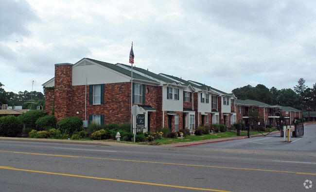
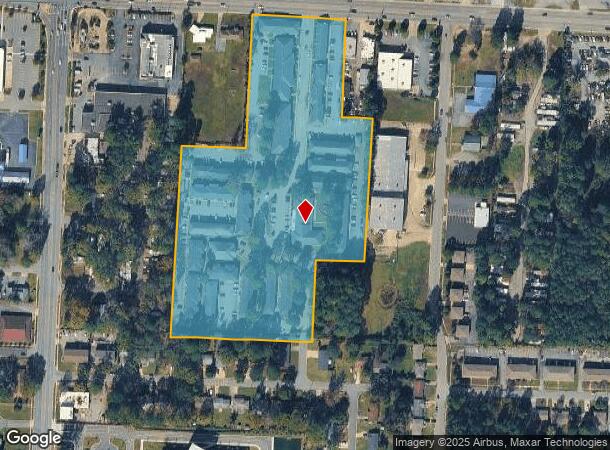
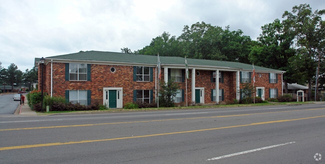
Property Record
5813 Baseline Rd, Little Rock, AR 72209
NEARBY LISTINGS FOR SALE OR LEASE
-
-
View all Little Rock listings for sale on LoopNet.com
Property Detail
5813 Baseline Rd
Little Rock-North Little Rock-Conway, AR
Sparks Acres
35L-001-63-001-00
PT TR 1 ALL TR 2 & PT TR 3 MPDA BEG SW COR OF SD TR 1 TH N ALG W LN OF SD TR 1 614 1' TH N89*42'30"E204 4' TO PT ON WLN OF SD TR 2 TH N00*05'E ALG SD W LN 423.46' TO PT ON S R/W BASELINE RD TH N89*42'30"E ALG SD R/W 305.4' TH S00*01'E311.75' TH N89*4
Apartment
Pulaski
X
Arkansas
05119C0462G
1
2025
10.86 AC
2025
Upper Baseline
004108
Little Rock/N Little Rock
41,652 SF
DEMOGRAPHICS near 5813 Baseline Rd
1 Mile
3 Mile
5 Mile
2024 Total Population
11,743
38,164
83,750
2029 Population
11,749
38,193
84,777
Pop Growth 2024-2029
+ 0.05%
+ 0.08%
+ 1.23%
Average Age
33
35
37
2024 Total Households
4,348
14,241
32,569
HH Growth 2024-2029
(0.02%)
+ 0.01%
+ 1.34%
Median Household Inc
$41,650
$41,504
$41,439
Avg Household Size
2.60
2.60
2.40
2024 Avg HH Vehicles
2.00
2.00
2.00
Median Home Value
$95,444
$95,396
$111,841
Median Year Built
1975
1973
1975
Nearby Places
Map Layers
Map Styles
 Street
 Aerial
- Restaurants
- Banks
- Shops
- Fitness
- Groceries
PUBLIC TRANSPORTATION
AIRPORT
Bill and Hillary Clinton Ntl/Adams Field
DRIVE
WALK
Distance
Bill and Hillary Clinton Ntl/Adams Field
14 min
9.9 mi
Freight Ports
Port of Shreveport
DRIVE
WALK
Distance
Port of Shreveport
243 min
226.1 mi
Nearby Properties
Address
Land Use
TOTAL SIZE
Lot Size
Zoning
Address
Land Use
TOTAL SIZE
Lot Size
Zoning
189,729 SF
57.75 AC
Address
Land Use
TOTAL SIZE
Lot Size
Zoning
10 SF
29.02 AC
Address
Land Use
TOTAL SIZE
Lot Size
Zoning
79,751 SF
28.57 AC
Address
Land Use
TOTAL SIZE
Lot Size
Zoning
239,345 SF
19.70 AC
Address
Land Use
TOTAL SIZE
Lot Size
Zoning
34,925 SF
12.59 AC
Address
Land Use
TOTAL SIZE
Lot Size
Zoning
50,433 SF
22.23 AC
Address
Land Use
TOTAL SIZE
Lot Size
Zoning
201,499 SF
21.70 AC
Address
Land Use
TOTAL SIZE
Lot Size
Zoning
131,278 SF
6.37 AC
Address
Land Use
TOTAL SIZE
Lot Size
Zoning
139,410 SF
8.35 AC
Address
Land Use
TOTAL SIZE
Lot Size
Zoning
24,520 SF
10.92 AC
Address
Land Use
TOTAL SIZE
Lot Size
Zoning
6,161 SF
40.08 AC
Address
Land Use
TOTAL SIZE
Lot Size
Zoning
35,069 SF
43.11 AC
Address
Land Use
TOTAL SIZE
Lot Size
Zoning
64,182 SF
17.80 AC
Address
Land Use
TOTAL SIZE
Lot Size
Zoning
59,076 SF
22.27 AC
Address
Land Use
TOTAL SIZE
Lot Size
Zoning
345,000 SF
13.21 AC
Address
Land Use
TOTAL SIZE
Lot Size
Zoning
33,216 SF
12.59 AC
Address
Land Use
TOTAL SIZE
Lot Size
Zoning
85,458 SF
9.86 AC
Address
Land Use
TOTAL SIZE
Lot Size
Zoning
10,629 SF
12 AC
Address
Land Use
TOTAL SIZE
Lot Size
Zoning
81,021 SF
10.28 AC
Address
Land Use
TOTAL SIZE
Lot Size
Zoning
19,440 SF
23.16 AC
Address
Land Use
TOTAL SIZE
Lot Size
Zoning
62,326 SF
5.84 AC
Address
Land Use
TOTAL SIZE
Lot Size
Zoning
573,416 SF
57.83 AC
Address
Land Use
TOTAL SIZE
Lot Size
Zoning
16,200 SF
6.90 AC
Address
Land Use
TOTAL SIZE
Lot Size
Zoning
2,881 SF
14.04 AC
Address
Land Use
TOTAL SIZE
Lot Size
Zoning
16,032 SF
11.71 AC
Address
Land Use
TOTAL SIZE
Lot Size
Zoning
58,156 SF
4.35 AC
Address
Land Use
TOTAL SIZE
Lot Size
Zoning
1,233 SF
6.19 AC
Address
Land Use
TOTAL SIZE
Lot Size
Zoning
38,640 SF
11.48 AC
Address
Land Use
TOTAL SIZE
Lot Size
Zoning
27,760 SF
9.95 AC
The World's #1 Commercial Real Estate Marketplace
Connect with us
© 2025 CoStar Group
The information above has been obtained from sources believed reliable. While we do not doubt its accuracy we have not verified it and make no guarantee, warranty or representation about it. It is your responsibility to independently confirm its accuracy and completeness. Any projections, opinions, assumptions, or estimates used are for example only and do not represent the current or future performance of the property. The value of this transaction to you depends on tax and other factors which should be evaluated by your tax, financial, and legal advisors. You and your advisors should conduct a careful, independent investigation of the property to determine to your satisfaction the suitability of the property for your needs.