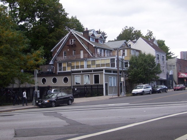
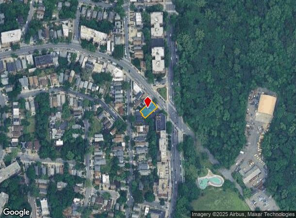
Property Record
5814 Mosholu Ave, Bronx, NY 10471
NEARBY LISTINGS FOR SALE OR LEASE
Property Detail
5814 Mosholu Ave
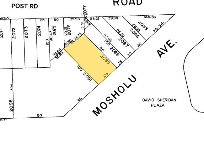
05851-2089
Bronx
Storebuilding
New York
X
2089
34003C0220H
0.11 AC
2024
Bronx
2025
Westchester/So Connecticut
034500
New York-Jersey City-White Plains, NY-NJ
2,880 SF
DEMOGRAPHICS near 5814 Mosholu Ave
1 Mile
3 Mile
5 Mile
2024 Total Population
42,080
495,760
1,368,252
2029 Population
40,304
467,335
1,286,383
Pop Growth 2024-2029
(4.22%)
(5.73%)
(5.98%)
Average Age
41
39
39
2024 Total Households
15,642
182,996
498,186
HH Growth 2024-2029
(4.72%)
(6.21%)
(6.43%)
Median Household Inc
$79,269
$54,484
$53,997
Avg Household Size
2.40
2.60
2.60
2024 Avg HH Vehicles
1.00
1.00
1.00
Median Home Value
$413,194
$466,766
$495,990
Median Year Built
1954
1949
1950
Nearby Places
Map Layers
Map Styles
 Street
 Aerial
- Restaurants
- Banks
- Shops
- Fitness
- Groceries
PUBLIC TRANSPORTATION
COMMUTER RAIL
Riverdale Station (Hudson Line - Metro-North Commuter Railroad Company (Metro-North))
DRIVE
WALK
Distance
Riverdale Station (Hudson Line - Metro-North Commuter Railroad Company (Metro-North))
3 min
1.3 mi
Ludlow Station (Hudson Line - Metro-North Commuter Railroad Company (Metro-North))
DRIVE
WALK
Distance
Ludlow Station (Hudson Line - Metro-North Commuter Railroad Company (Metro-North))
4 min
1.9 mi
AIRPORT
LaGuardia
DRIVE
WALK
Distance
LaGuardia
24 min
13.4 mi
John F Kennedy International
DRIVE
WALK
Distance
John F Kennedy International
35 min
22.9 mi
Westchester County
DRIVE
WALK
Distance
Westchester County
32 min
23.9 mi
Freight Ports
NY - Red Hook Container Terminal
DRIVE
WALK
Distance
NY - Red Hook Container Terminal
36 min
21.6 mi
Nearby Properties
Address
Land Use
TOTAL SIZE
Lot Size
Zoning
Address
Land Use
TOTAL SIZE
Lot Size
Zoning
1,299,700 SF
29.82 AC
R6
Address
Land Use
TOTAL SIZE
Lot Size
Zoning
111.37 AC
P1
Address
Land Use
TOTAL SIZE
Lot Size
Zoning
72 AC
P1
Address
Land Use
TOTAL SIZE
Lot Size
Zoning
481,172 SF
205.58 AC
PARK
Address
Land Use
TOTAL SIZE
Lot Size
Zoning
895,256 SF
8.32 AC
R7-1
Address
Land Use
TOTAL SIZE
Lot Size
Zoning
1,237,424 SF
21.25 AC
R6
Address
Land Use
TOTAL SIZE
Lot Size
Zoning
219.71 AC
O
Address
Land Use
TOTAL SIZE
Lot Size
Zoning
204,200 SF
1.68 AC
R7-1
Address
Land Use
TOTAL SIZE
Lot Size
Zoning
100,151 SF
22.13 AC
B2
Address
Land Use
TOTAL SIZE
Lot Size
Zoning
617,567 SF
3.19 AC
R7-1
Address
Land Use
TOTAL SIZE
Lot Size
Zoning
707,353 SF
29.34 AC
R6
Address
Land Use
TOTAL SIZE
Lot Size
Zoning
15.76 AC
B2
Address
Land Use
TOTAL SIZE
Lot Size
Zoning
259.87 AC
PARK
Address
Land Use
TOTAL SIZE
Lot Size
Zoning
393,924 SF
4.50 AC
R7-2
Address
Land Use
TOTAL SIZE
Lot Size
Zoning
135.51 AC
RR
Address
Land Use
TOTAL SIZE
Lot Size
Zoning
94.42 AC
P
Address
Land Use
TOTAL SIZE
Lot Size
Zoning
Address
Land Use
TOTAL SIZE
Lot Size
Zoning
269,100 SF
1.63 AC
R4
Address
Land Use
TOTAL SIZE
Lot Size
Zoning
87,000 SF
455.70 AC
PARK
Address
Land Use
TOTAL SIZE
Lot Size
Zoning
225.36 AC
O
Address
Land Use
TOTAL SIZE
Lot Size
Zoning
450,784 SF
42.36 AC
R4
Address
Land Use
TOTAL SIZE
Lot Size
Zoning
18,445 SF
510.83 AC
PARK
Address
Land Use
TOTAL SIZE
Lot Size
Zoning
251,884 SF
21.53 AC
R6
Address
Land Use
TOTAL SIZE
Lot Size
Zoning
9.48 AC
RA
Address
Land Use
TOTAL SIZE
Lot Size
Zoning
28.78 AC
B2
Address
Land Use
TOTAL SIZE
Lot Size
Zoning
1,028,976 SF
23.03 AC
R5
Address
Land Use
TOTAL SIZE
Lot Size
Zoning
677,078 SF
4.91 AC
R6
Address
Land Use
TOTAL SIZE
Lot Size
Zoning
614,887 SF
14.77 AC
R4
Address
Land Use
TOTAL SIZE
Lot Size
Zoning
1,038,034 SF
23.41 AC
R5
Address
Land Use
TOTAL SIZE
Lot Size
Zoning
244,650 SF
2 AC
R7-1
The World's #1 Commercial Real Estate Marketplace
Connect with us
© 2025 CoStar Group
The information above has been obtained from sources believed reliable. While we do not doubt its accuracy we have not verified it and make no guarantee, warranty or representation about it. It is your responsibility to independently confirm its accuracy and completeness. Any projections, opinions, assumptions, or estimates used are for example only and do not represent the current or future performance of the property. The value of this transaction to you depends on tax and other factors which should be evaluated by your tax, financial, and legal advisors. You and your advisors should conduct a careful, independent investigation of the property to determine to your satisfaction the suitability of the property for your needs.