Property Record
5815 Eads Rd, Neosho, MO 64850
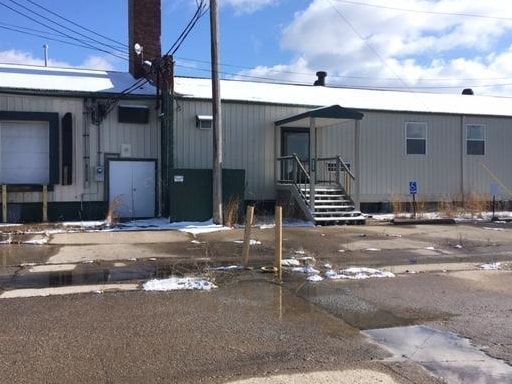


Property Detail
5815 Eads Rd
21-5.0-16-000-000-013.000
PT SE1/4 SW1/4 BEG INTERS SEC & EADS NELY 360 SELY 110.88 SWLY 270 W 145 TO POB
Warehouse
Newton
B and X Area of moderate flood hazard, usually the area between the limits of the 100-year and 500-year floods.
Missouri
2024
0.79 AC
2025
Missouri South Area
020800
Other Market Areas
34,718 SF
Joplin, MO-KS
NEARBY LISTINGS FOR SALE OR LEASE
DEMOGRAPHICS near 5815 Eads Rd
1 mile
3 mile
5 mile
2025 Total Population
512
3,624
17,774
2030 Population
534
3,779
18,467
Pop Growth 2025-2030
+ 4.30%
+ 4.28%
+ 3.90%
Average Age
38
38
38
2025 Total Households
186
1,307
6,585
HH Growth 2025-2030
+ 3.76%
+ 4.44%
+ 3.93%
Median Household Inc
$65,543
$61,334
$60,017
Avg Household Size
2.70
2.50
2.60
2025 Avg HH Vehicles
2.00
2.00
2.00
Median Home Value
$160,144
$176,299
$168,757
Median Year Built
1992
1990
1976
Nearby Places
Map Layers
Map Styles
 Street
 Aerial
Layers
 Traffic
 Biking
Places
Listings with unknown addresses are not visible on the map
- Restaurants
- Banks
- Shops
- Fitness
- Groceries
SALE & LEASE HISTORY
LISTING DATE
SALE/LEASE

Feb 12, 2020
For Sale
Nearby Properties
Address
Land Use
TOTAL SIZE
Lot Size
Zoning
Address
Land Use
TOTAL SIZE
Lot Size
Zoning
159,394 SF
28.53 AC
Address
Land Use
TOTAL SIZE
Lot Size
Zoning
508,660 SF
194.60 AC
Address
Land Use
TOTAL SIZE
Lot Size
Zoning
606,414 SF
29.75 AC
Address
Land Use
TOTAL SIZE
Lot Size
Zoning
110,944 SF
11.32 AC
Address
Land Use
TOTAL SIZE
Lot Size
Zoning
168,000 SF
6.90 AC
Address
Land Use
TOTAL SIZE
Lot Size
Zoning
366,416 SF
113.50 AC
Address
Land Use
TOTAL SIZE
Lot Size
Zoning
24,100 SF
3.02 AC
Address
Land Use
TOTAL SIZE
Lot Size
Zoning
13,965 SF
3.06 AC
Address
Land Use
TOTAL SIZE
Lot Size
Zoning
113,139 SF
43.74 AC
Address
Land Use
TOTAL SIZE
Lot Size
Zoning
187,700 SF
8.90 AC
Address
Land Use
TOTAL SIZE
Lot Size
Zoning
53,674 SF
9.92 AC
Address
Land Use
TOTAL SIZE
Lot Size
Zoning
112,456 SF
4.68 AC
Address
Land Use
TOTAL SIZE
Lot Size
Zoning
12,934 SF
2.82 AC
Address
Land Use
TOTAL SIZE
Lot Size
Zoning
37,976 SF
3.30 AC
Address
Land Use
TOTAL SIZE
Lot Size
Zoning
36,456 SF
9.15 AC
Address
Land Use
TOTAL SIZE
Lot Size
Zoning
53,400 SF
2.92 AC
Address
Land Use
TOTAL SIZE
Lot Size
Zoning
24,170 SF
4.03 AC
Address
Land Use
TOTAL SIZE
Lot Size
Zoning
70,608 SF
8.70 AC
Address
Land Use
TOTAL SIZE
Lot Size
Zoning
79,435 SF
1.82 AC
Address
Land Use
TOTAL SIZE
Lot Size
Zoning
35,680 SF
14.05 AC
Address
Land Use
TOTAL SIZE
Lot Size
Zoning
14,760 SF
Address
Land Use
TOTAL SIZE
Lot Size
Zoning
41,172 SF
5.61 AC
Address
Land Use
TOTAL SIZE
Lot Size
Zoning
65,210 SF
6.36 AC
The World's #1 Commercial Real Estate Marketplace
Connect with us
© 2026 CoStar Group
The information above has been obtained from sources believed reliable. While we do not doubt its accuracy we have not verified it and make no guarantee, warranty or representation about it. It is your responsibility to independently confirm its accuracy and completeness. Any projections, opinions, assumptions, or estimates used are for example only and do not represent the current or future performance of the property. The value of this transaction to you depends on tax and other factors which should be evaluated by your tax, financial, and legal advisors. You and your advisors should conduct a careful, independent investigation of the property to determine to your satisfaction the suitability of the property for your needs.