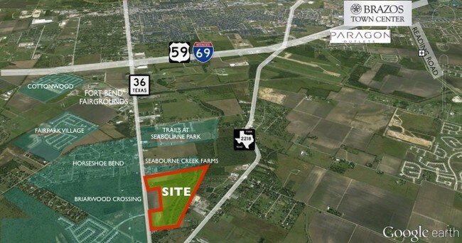
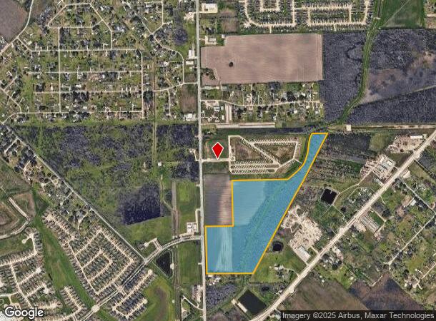
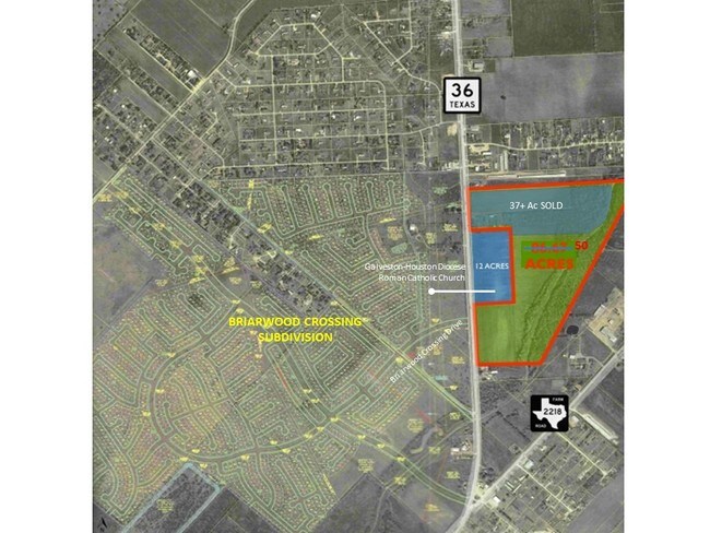
Property Record
5815 Highway 36 S, Rosenberg, TX 77471
NEARBY LISTINGS FOR SALE OR LEASE
Property Detail
5815 Highway 36 S
Houston-The Woodlands-Sugar Land, TX
Bbb And C Ry
0131-00-009-0245-901
0131 BBB AND C RY, TRACT 1, ACRES 50.33, (TR 24 PT)
Farms
Fort Bend
AE
Texas
48157C0400M
24
2024
50.33 AC
2025
Southwest Outlier
675501
Houston
DEMOGRAPHICS near 5815 Highway 36 S
1 Mile
3 Mile
5 Mile
2024 Total Population
4,788
18,769
67,510
2029 Population
5,871
22,892
82,075
Pop Growth 2024-2029
+ 22.62%
+ 21.97%
+ 21.57%
Average Age
34
35
36
2024 Total Households
1,399
5,853
22,187
HH Growth 2024-2029
+ 23.23%
+ 22.50%
+ 22.13%
Median Household Inc
$70,375
$69,259
$65,821
Avg Household Size
3.30
3.20
3.00
2024 Avg HH Vehicles
2.00
2.00
2.00
Median Home Value
$244,708
$218,782
$229,057
Median Year Built
2010
2010
2005
Nearby Places
Map Layers
Map Styles
 Street
 Aerial
- Restaurants
- Banks
- Shops
- Fitness
- Groceries
SALE & LEASE HISTORY
LISTING DATE
SALE/LEASE

Sep 24, 2016
For Sale
Nearby Properties
Address
Land Use
TOTAL SIZE
Lot Size
Zoning
Address
Land Use
TOTAL SIZE
Lot Size
Zoning
44.35 AC
YOSN
Address
Land Use
TOTAL SIZE
Lot Size
Zoning
17.73 AC
Address
Land Use
TOTAL SIZE
Lot Size
Zoning
11.40 AC
Address
Land Use
TOTAL SIZE
Lot Size
Zoning
Address
Land Use
TOTAL SIZE
Lot Size
Zoning
98,691 SF
29.37 AC
Address
Land Use
TOTAL SIZE
Lot Size
Zoning
Address
Land Use
TOTAL SIZE
Lot Size
Zoning
54,406 SF
13.13 AC
Address
Land Use
TOTAL SIZE
Lot Size
Zoning
18.86 AC
Address
Land Use
TOTAL SIZE
Lot Size
Zoning
64.02 AC
YQ
Address
Land Use
TOTAL SIZE
Lot Size
Zoning
1,216 SF
24.38 AC
YZS
Address
Land Use
TOTAL SIZE
Lot Size
Zoning
Address
Land Use
TOTAL SIZE
Lot Size
Zoning
25.69 AC
Address
Land Use
TOTAL SIZE
Lot Size
Zoning
4,524 SF
13.68 AC
Address
Land Use
TOTAL SIZE
Lot Size
Zoning
145,000 SF
17.36 AC
YSNM
Address
Land Use
TOTAL SIZE
Lot Size
Zoning
7.16 AC
Address
Land Use
TOTAL SIZE
Lot Size
Zoning
14.18 AC
Address
Land Use
TOTAL SIZE
Lot Size
Zoning
133,826 SF
11.60 AC
Address
Land Use
TOTAL SIZE
Lot Size
Zoning
7.89 AC
SZ
Address
Land Use
TOTAL SIZE
Lot Size
Zoning
40.49 AC
OY
Address
Land Use
TOTAL SIZE
Lot Size
Zoning
175,001 SF
14.37 AC
SY
Address
Land Use
TOTAL SIZE
Lot Size
Zoning
72,400 SF
10 AC
Address
Land Use
TOTAL SIZE
Lot Size
Zoning
Address
Land Use
TOTAL SIZE
Lot Size
Zoning
12,869 SF
5.11 AC
Address
Land Use
TOTAL SIZE
Lot Size
Zoning
21,867 SF
70.17 AC
Address
Land Use
TOTAL SIZE
Lot Size
Zoning
288.44 AC
Address
Land Use
TOTAL SIZE
Lot Size
Zoning
9.57 AC
Address
Land Use
TOTAL SIZE
Lot Size
Zoning
10.06 AC
ST
Address
Land Use
TOTAL SIZE
Lot Size
Zoning
1,965 SF
170.82 AC
SOYK
Address
Land Use
TOTAL SIZE
Lot Size
Zoning
134.60 AC
Address
Land Use
TOTAL SIZE
Lot Size
Zoning
The World's #1 Commercial Real Estate Marketplace
Connect with us
© 2025 CoStar Group
The information above has been obtained from sources believed reliable. While we do not doubt its accuracy we have not verified it and make no guarantee, warranty or representation about it. It is your responsibility to independently confirm its accuracy and completeness. Any projections, opinions, assumptions, or estimates used are for example only and do not represent the current or future performance of the property. The value of this transaction to you depends on tax and other factors which should be evaluated by your tax, financial, and legal advisors. You and your advisors should conduct a careful, independent investigation of the property to determine to your satisfaction the suitability of the property for your needs.