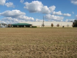
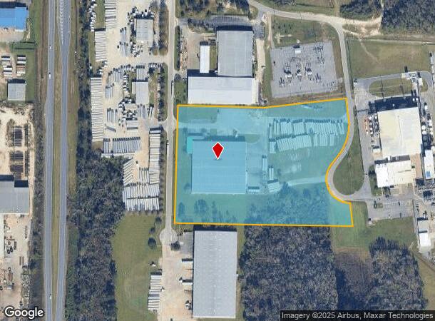
Property Record
5815 Production Way, Valdosta, GA 31606
NEARBY LISTINGS FOR SALE OR LEASE
Property Detail
5815 Production Way
Valdosta, GA
Big Noise Industrial
0186-115
LT 2 BLK A PERIMETER EAST INDUST
Warehouse
Lowndes
X
Georgia
13101C0025A
2
2024
10 AC
2024
Valdosta/Lake Park
010700
Other Market Areas
63,960 SF
DEMOGRAPHICS near 5815 Production Way
1 Mile
3 Mile
5 Mile
2024 Total Population
208
12,330
50,562
2029 Population
217
12,929
52,622
Pop Growth 2024-2029
+ 4.33%
+ 4.86%
+ 4.07%
Average Age
39
36
35
2024 Total Households
81
4,774
19,416
HH Growth 2024-2029
+ 4.94%
+ 4.96%
+ 4.31%
Median Household Inc
$32,916
$24,371
$28,310
Avg Household Size
2.60
2.50
2.40
2024 Avg HH Vehicles
2.00
1.00
2.00
Median Home Value
$190,624
$94,290
$120,044
Median Year Built
1988
1984
1985
Nearby Places
Map Layers
Map Styles
 Street
 Aerial
- Restaurants
- Banks
- Shops
- Fitness
- Groceries
PUBLIC TRANSPORTATION
AIRPORT
Valdosta Regional
DRIVE
WALK
Distance
Valdosta Regional
10 min
6.6 mi
Freight Ports
Jacksonville Port
DRIVE
WALK
Distance
Jacksonville Port
146 min
125.6 mi
Nearby Properties
Address
Land Use
TOTAL SIZE
Lot Size
Zoning
Address
Land Use
TOTAL SIZE
Lot Size
Zoning
60,000 SF
56.32 AC
M-1
Address
Land Use
TOTAL SIZE
Lot Size
Zoning
339 SF
23.53 AC
E-R
Address
Land Use
TOTAL SIZE
Lot Size
Zoning
7,200 SF
9.92 AC
M-1
Address
Land Use
TOTAL SIZE
Lot Size
Zoning
166,300 SF
43.05 AC
M-2
Address
Land Use
TOTAL SIZE
Lot Size
Zoning
100,000 SF
25.27 AC
M-1
Address
Land Use
TOTAL SIZE
Lot Size
Zoning
2,610 SF
10 AC
R-M
Address
Land Use
TOTAL SIZE
Lot Size
Zoning
480 SF
10 AC
R-M
Address
Land Use
TOTAL SIZE
Lot Size
Zoning
9,000 SF
72.18 AC
E-A
Address
Land Use
TOTAL SIZE
Lot Size
Zoning
18,936 SF
6.45 AC
R-M
Address
Land Use
TOTAL SIZE
Lot Size
Zoning
8,320 SF
61 AC
E-A
Address
Land Use
TOTAL SIZE
Lot Size
Zoning
66,395 SF
1.49 AC
M-1
Address
Land Use
TOTAL SIZE
Lot Size
Zoning
90,710 SF
33.43 AC
PRD-10
Address
Land Use
TOTAL SIZE
Lot Size
Zoning
12,650 SF
55.68 AC
M-2
Address
Land Use
TOTAL SIZE
Lot Size
Zoning
80,000 SF
11.51 AC
M-2
Address
Land Use
TOTAL SIZE
Lot Size
Zoning
14,464 SF
4.01 AC
R-M
Address
Land Use
TOTAL SIZE
Lot Size
Zoning
150,862 SF
30 AC
M-1
Address
Land Use
TOTAL SIZE
Lot Size
Zoning
37,321 SF
6.35 AC
R-P
Address
Land Use
TOTAL SIZE
Lot Size
Zoning
17,920 SF
6 AC
R-M
Address
Land Use
TOTAL SIZE
Lot Size
Zoning
8,000 SF
18.89 AC
M-1
Address
Land Use
TOTAL SIZE
Lot Size
Zoning
16,100 SF
28 AC
M-2
Address
Land Use
TOTAL SIZE
Lot Size
Zoning
193.02 AC
M-1
Address
Land Use
TOTAL SIZE
Lot Size
Zoning
35,586 SF
28.93 AC
R-10
Address
Land Use
TOTAL SIZE
Lot Size
Zoning
41,850 SF
7.89 AC
M-1
Address
Land Use
TOTAL SIZE
Lot Size
Zoning
59,106 SF
23.93 AC
O-I
Address
Land Use
TOTAL SIZE
Lot Size
Zoning
55,000 SF
7.58 AC
M-1
Address
Land Use
TOTAL SIZE
Lot Size
Zoning
47,645 SF
5.06 AC
R-P
Address
Land Use
TOTAL SIZE
Lot Size
Zoning
64,064 SF
6.81 AC
R-6
Address
Land Use
TOTAL SIZE
Lot Size
Zoning
6,310 SF
4.14 AC
M-1
Address
Land Use
TOTAL SIZE
Lot Size
Zoning
35,200 SF
4.84 AC
M-2
The World's #1 Commercial Real Estate Marketplace
Connect with us
© 2026 CoStar Group
The information above has been obtained from sources believed reliable. While we do not doubt its accuracy we have not verified it and make no guarantee, warranty or representation about it. It is your responsibility to independently confirm its accuracy and completeness. Any projections, opinions, assumptions, or estimates used are for example only and do not represent the current or future performance of the property. The value of this transaction to you depends on tax and other factors which should be evaluated by your tax, financial, and legal advisors. You and your advisors should conduct a careful, independent investigation of the property to determine to your satisfaction the suitability of the property for your needs.