Property Record
582 Seaside Rd Sw, Sunset Beach, NC 28468

Save to a Folder
{{folder.Name}}
{{folder.ListingIds.length}} Properties
{{folder.ListingIds.length}} Property
Create a New Folder
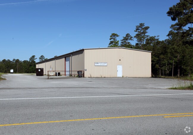
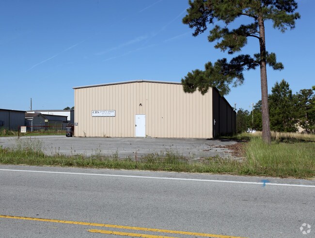
Property Detail
582 Seaside Rd Sw
2270001101
9.970 AC PL-153/77
Warehouse
Brunswick
CLD
North Carolina
B and X Area of moderate flood hazard, usually the area between the limits of the 100-year and 500-year floods.
9.97 AC
2025
West Brunswick
2025
Wilmington
020508
Wilmington, NC
9,000 SF
NEARBY LISTINGS FOR SALE OR LEASE
-
-
View all Sunset Beach listings for lease on LoopNet.com
DEMOGRAPHICS near 582 Seaside Rd Sw
1 mile
3 mile
5 mile
2025 Total Population
878
11,172
31,259
2030 Population
1,026
13,422
37,393
Pop Growth 2025-2030
+ 16.86%
+ 20.14%
+ 19.62%
Average Age
62
59
58
2025 Total Households
448
5,665
15,514
HH Growth 2025-2030
+ 16.96%
+ 20.16%
+ 19.64%
Median Household Inc
$100,847
$88,508
$81,918
Avg Household Size
1.90
1.90
2.00
2025 Avg HH Vehicles
2.00
2.00
2.00
Median Home Value
$523,809
$415,401
$372,918
Median Year Built
2006
2007
2004
Nearby Places
Map Layers
Map Styles
 Street
 Aerial
Layers
 Traffic
 Biking
Places
Listings with unknown addresses are not visible on the map
- Restaurants
- Banks
- Shops
- Fitness
- Groceries
PUBLIC TRANSPORTATION
AIRPORT
Myrtle Beach International
Drive
Walk
Distance
Myrtle Beach International
55 min
37.7 mi
Wilmington International
Drive
Walk
Distance
Wilmington International
74 min
48.7 mi
Freight Ports
Port of Wilmington
Drive
Walk
Distance
Port of Wilmington
64 min
44.5 mi
SALE & LEASE HISTORY
LISTING DATE
SALE/LEASE

Sep 24, 2016
For Sale
Oct 04, 2016
For Lease
Nearby Properties
Address
Land Use
TOTAL SIZE
Lot Size
Zoning
Address
Land Use
TOTAL SIZE
Lot Size
Zoning
1,632 SF
4.96 AC
MUD
Address
Land Use
TOTAL SIZE
Lot Size
Zoning
84,689 SF
6.17 AC
MR3
Address
Land Use
TOTAL SIZE
Lot Size
Zoning
75,455 SF
29.84 AC
R75
Address
Land Use
TOTAL SIZE
Lot Size
Zoning
45,468 SF
6.57 AC
MUD
Address
Land Use
TOTAL SIZE
Lot Size
Zoning
31,565 SF
4.46 AC
MR3
Address
Land Use
TOTAL SIZE
Lot Size
Zoning
750 SF
11.80 AC
CLD
Address
Land Use
TOTAL SIZE
Lot Size
Zoning
14,000 SF
7.54 AC
CLD
Address
Land Use
TOTAL SIZE
Lot Size
Zoning
19,200 SF
19.26 AC
CLD
Address
Land Use
TOTAL SIZE
Lot Size
Zoning
23,100 SF
7 AC
CLD
Address
Land Use
TOTAL SIZE
Lot Size
Zoning
14,736 SF
2.21 AC
MB1
Address
Land Use
TOTAL SIZE
Lot Size
Zoning
243.49 AC
C3
Address
Land Use
TOTAL SIZE
Lot Size
Zoning
7,335 SF
2.16 AC
CLD
Address
Land Use
TOTAL SIZE
Lot Size
Zoning
2,275 SF
6.78 AC
CLD
Address
Land Use
TOTAL SIZE
Lot Size
Zoning
17,575 SF
6.41 AC
CLD
Address
Land Use
TOTAL SIZE
Lot Size
Zoning
9,096 SF
6.03 AC
CLD
Address
Land Use
TOTAL SIZE
Lot Size
Zoning
311.36 AC
MR3
Address
Land Use
TOTAL SIZE
Lot Size
Zoning
12,383 SF
3.88 AC
RI1
Address
Land Use
TOTAL SIZE
Lot Size
Zoning
10,125 SF
1.61 AC
MB1
Address
Land Use
TOTAL SIZE
Lot Size
Zoning
11,724 SF
14.05 AC
CLD
Address
Land Use
TOTAL SIZE
Lot Size
Zoning
5.03 AC
MR3
Address
Land Use
TOTAL SIZE
Lot Size
Zoning
11,604 SF
2.27 AC
MB2
Address
Land Use
TOTAL SIZE
Lot Size
Zoning
9,283 SF
1.38 AC
MB2
Address
Land Use
TOTAL SIZE
Lot Size
Zoning
7,500 SF
45.55 AC
CLD
Address
Land Use
TOTAL SIZE
Lot Size
Zoning
10,960 SF
1.61 AC
MB1
Address
Land Use
TOTAL SIZE
Lot Size
Zoning
2,870 SF
288.53 AC
R75
Address
Land Use
TOTAL SIZE
Lot Size
Zoning
11,910 SF
2.09 AC
MB1
Address
Land Use
TOTAL SIZE
Lot Size
Zoning
20,315 SF
1.43 AC
MB1
Address
Land Use
TOTAL SIZE
Lot Size
Zoning
9,600 SF
5.23 AC
MR3
The World's #1 Commercial Real Estate Marketplace
Connect with us
© 2026 CoStar Group
The information above has been obtained from sources believed reliable. While we do not doubt its accuracy we have not verified it and make no guarantee, warranty or representation about it. It is your responsibility to independently confirm its accuracy and completeness. Any projections, opinions, assumptions, or estimates used are for example only and do not represent the current or future performance of the property. The value of this transaction to you depends on tax and other factors which should be evaluated by your tax, financial, and legal advisors. You and your advisors should conduct a careful, independent investigation of the property to determine to your satisfaction the suitability of the property for your needs.