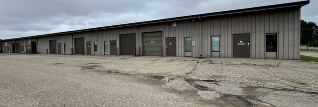
Property Record
5821 Femrite Dr, Madison, WI 53718

Current Lease Availabilities
NEARBY LISTINGS FOR SALE OR LEASE
Property Detail
5821 Femrite Dr
Madison, WI
Certified Survey Map No 1495 As Recorded
0710-233-0202-0
CERTIFIED SURVEY MAP NO 1495 AS RECORDED IN DANE COUNTY REGISTER OF DEEDS IN VOL 6 PAGES 201-202 OF CERTIFIED SURVEYS, LOT 3 EXC THAT PRT OF LOT 3 LYING N OF A LN 110 FT S OF N LN SE 1/4 SW 1/4 SEC 23, T7N R10E & PRT OF LOT 4 DESC AS FOL: B EG SW COR
Commercialnec
Dane
X
Wisconsin
55025C0442H
3
2024
4.10 AC
2024
Southeast Madison
003100
Milwaukee/Madison
44,000 SF
DEMOGRAPHICS near 5821 Femrite Dr
1 Mile
3 Mile
5 Mile
2024 Total Population
118
37,166
93,079
2029 Population
121
38,476
96,699
Pop Growth 2024-2029
+ 2.54%
+ 3.52%
+ 3.89%
Average Age
44
41
40
2024 Total Households
55
16,062
41,025
HH Growth 2024-2029
+ 1.82%
+ 3.60%
+ 3.97%
Median Household Inc
$85,714
$83,795
$79,871
Avg Household Size
2.10
2.20
2.20
2024 Avg HH Vehicles
2.00
2.00
2.00
Median Home Value
$299,999
$296,666
$300,381
Median Year Built
1994
1983
1977
Nearby Places
Map Layers
Map Styles
 Street
 Aerial
- Restaurants
- Banks
- Shops
- Fitness
- Groceries
PUBLIC TRANSPORTATION
AIRPORT
Dane County Regional/Truax Field
DRIVE
WALK
Distance
Dane County Regional/Truax Field
17 min
9.7 mi
Nearby Properties
Address
Land Use
TOTAL SIZE
Lot Size
Zoning
Address
Land Use
TOTAL SIZE
Lot Size
Zoning
168,685 SF
14.05 AC
IL
Address
Land Use
TOTAL SIZE
Lot Size
Zoning
13,440 SF
10.98 AC
IL
Address
Land Use
TOTAL SIZE
Lot Size
Zoning
2.03 AC
Address
Land Use
TOTAL SIZE
Lot Size
Zoning
3.59 AC
Address
Land Use
TOTAL SIZE
Lot Size
Zoning
12,450 SF
9.40 AC
SE
Address
Land Use
TOTAL SIZE
Lot Size
Zoning
2.38 AC
Address
Land Use
TOTAL SIZE
Lot Size
Zoning
225,108 SF
2 AC
PD
Address
Land Use
TOTAL SIZE
Lot Size
Zoning
19.81 AC
Address
Land Use
TOTAL SIZE
Lot Size
Zoning
149,897 SF
17.72 AC
IL
Address
Land Use
TOTAL SIZE
Lot Size
Zoning
5.53 AC
Address
Land Use
TOTAL SIZE
Lot Size
Zoning
3.49 AC
Address
Land Use
TOTAL SIZE
Lot Size
Zoning
6,868 SF
18.35 AC
IL
Address
Land Use
TOTAL SIZE
Lot Size
Zoning
167,519 SF
4.51 AC
PD
Address
Land Use
TOTAL SIZE
Lot Size
Zoning
202,800 SF
13.05 AC
IL
Address
Land Use
TOTAL SIZE
Lot Size
Zoning
154,403 SF
1.21 AC
PD
Address
Land Use
TOTAL SIZE
Lot Size
Zoning
217,952 SF
6.47 AC
PD
Address
Land Use
TOTAL SIZE
Lot Size
Zoning
176,496 SF
3.51 AC
PD
Address
Land Use
TOTAL SIZE
Lot Size
Zoning
156,368 SF
4.01 AC
PD
Address
Land Use
TOTAL SIZE
Lot Size
Zoning
16.40 AC
IL
Address
Land Use
TOTAL SIZE
Lot Size
Zoning
280,000 SF
15.01 AC
IL
Address
Land Use
TOTAL SIZE
Lot Size
Zoning
10.45 AC
IL
Address
Land Use
TOTAL SIZE
Lot Size
Zoning
49,562 SF
4.42 AC
SE
Address
Land Use
TOTAL SIZE
Lot Size
Zoning
17,980 SF
6.25 AC
SR-V2
Address
Land Use
TOTAL SIZE
Lot Size
Zoning
111,768 SF
2.38 AC
PD
Address
Land Use
TOTAL SIZE
Lot Size
Zoning
134,814 SF
3.79 AC
SR-V2
Address
Land Use
TOTAL SIZE
Lot Size
Zoning
9,030 SF
6.59 AC
SR-V2
Address
Land Use
TOTAL SIZE
Lot Size
Zoning
42,967 SF
5.25 AC
SR-V2
Address
Land Use
TOTAL SIZE
Lot Size
Zoning
113,341 SF
11.66 AC
IL
Address
Land Use
TOTAL SIZE
Lot Size
Zoning
131,874 SF
8.98 AC
IL
Address
Land Use
TOTAL SIZE
Lot Size
Zoning
14.34 AC
IL
The World's #1 Commercial Real Estate Marketplace
Connect with us
© 2026 CoStar Group
The information above has been obtained from sources believed reliable. While we do not doubt its accuracy we have not verified it and make no guarantee, warranty or representation about it. It is your responsibility to independently confirm its accuracy and completeness. Any projections, opinions, assumptions, or estimates used are for example only and do not represent the current or future performance of the property. The value of this transaction to you depends on tax and other factors which should be evaluated by your tax, financial, and legal advisors. You and your advisors should conduct a careful, independent investigation of the property to determine to your satisfaction the suitability of the property for your needs.