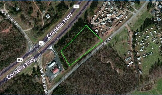
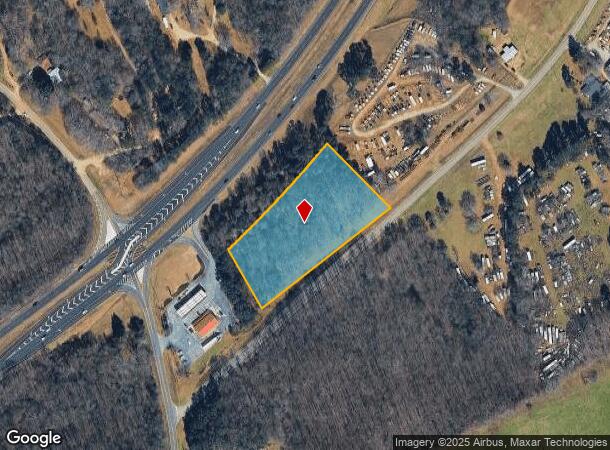
Property Record
5822 Cornelia Hwy, Alto, GA 30510
NEARBY LISTINGS FOR SALE OR LEASE
Property Detail
5822 Cornelia Hwy
09-00005-00-015
CORNELIA HIGHWAY
Commercialacreage
Hall
X
Georgia
13139C0125H
2.50 AC
2025
Gainesville/Hall County
2025
Atlanta
000101
Gainesville, GA
DEMOGRAPHICS near 5822 Cornelia Hwy
1 Mile
3 Mile
5 Mile
2024 Total Population
625
6,365
13,824
2029 Population
691
7,014
15,365
Pop Growth 2024-2029
+ 10.56%
+ 10.20%
+ 11.15%
Average Age
39
38
39
2024 Total Households
231
1,767
4,486
HH Growth 2024-2029
+ 10.39%
+ 11.38%
+ 11.52%
Median Household Inc
$55,217
$53,231
$55,268
Avg Household Size
2.70
2.70
2.70
2024 Avg HH Vehicles
2.00
2.00
2.00
Median Home Value
$189,422
$178,947
$187,228
Median Year Built
1996
1995
1994
Nearby Places
Map Layers
Map Styles
 Street
 Aerial
- Restaurants
- Banks
- Shops
- Fitness
- Groceries
SALE & LEASE HISTORY
LISTING DATE
SALE/LEASE

Feb 02, 2017
For Sale
Nearby Properties
Address
Land Use
TOTAL SIZE
Lot Size
Zoning
Address
Land Use
TOTAL SIZE
Lot Size
Zoning
1,603.88 AC
PRD/PCD
Address
Land Use
TOTAL SIZE
Lot Size
Zoning
2,176 SF
42.65 AC
M1
Address
Land Use
TOTAL SIZE
Lot Size
Zoning
11,715 SF
4.43 AC
I-1
Address
Land Use
TOTAL SIZE
Lot Size
Zoning
236.84 AC
AR-1
Address
Land Use
TOTAL SIZE
Lot Size
Zoning
20.98 AC
LI
Address
Land Use
TOTAL SIZE
Lot Size
Zoning
84.25 AC
PID
Address
Land Use
TOTAL SIZE
Lot Size
Zoning
10,272 SF
2.05 AC
I-1
Address
Land Use
TOTAL SIZE
Lot Size
Zoning
19,344 SF
2.15 AC
MUNI
Address
Land Use
TOTAL SIZE
Lot Size
Zoning
18,900 SF
4.01 AC
MUNI
Address
Land Use
TOTAL SIZE
Lot Size
Zoning
12,178 SF
2.76 AC
MUNI
Address
Land Use
TOTAL SIZE
Lot Size
Zoning
10,000 SF
5.16 AC
MUNI
Address
Land Use
TOTAL SIZE
Lot Size
Zoning
9,625 SF
20 AC
LI
Address
Land Use
TOTAL SIZE
Lot Size
Zoning
29.96 AC
PID
Address
Land Use
TOTAL SIZE
Lot Size
Zoning
152.74 AC
AR-1
Address
Land Use
TOTAL SIZE
Lot Size
Zoning
18,000 SF
4.02 AC
MUNI
Address
Land Use
TOTAL SIZE
Lot Size
Zoning
228.90 AC
A-I
Address
Land Use
TOTAL SIZE
Lot Size
Zoning
5,000 SF
3.21 AC
MUNI
Address
Land Use
TOTAL SIZE
Lot Size
Zoning
138.87 AC
AR-1
Address
Land Use
TOTAL SIZE
Lot Size
Zoning
10,440 SF
1.18 AC
AR-IV
Address
Land Use
TOTAL SIZE
Lot Size
Zoning
122.56 AC
AR-1
Address
Land Use
TOTAL SIZE
Lot Size
Zoning
122.36 AC
AR-1
Address
Land Use
TOTAL SIZE
Lot Size
Zoning
119.42 AC
AR-1
Address
Land Use
TOTAL SIZE
Lot Size
Zoning
13,000 SF
0.98 AC
MI
Address
Land Use
TOTAL SIZE
Lot Size
Zoning
64.68 AC
AR-1
Address
Land Use
TOTAL SIZE
Lot Size
Zoning
141.50 AC
AR-1
Address
Land Use
TOTAL SIZE
Lot Size
Zoning
7,200 SF
2.86 AC
MUNI
Address
Land Use
TOTAL SIZE
Lot Size
Zoning
108.22 AC
LI
Address
Land Use
TOTAL SIZE
Lot Size
Zoning
101.20 AC
LI
Address
Land Use
TOTAL SIZE
Lot Size
Zoning
94.52 AC
AR-1
Address
Land Use
TOTAL SIZE
Lot Size
Zoning
12,000 SF
4.50 AC
HI
The World's #1 Commercial Real Estate Marketplace
Connect with us
© 2025 CoStar Group
The information above has been obtained from sources believed reliable. While we do not doubt its accuracy we have not verified it and make no guarantee, warranty or representation about it. It is your responsibility to independently confirm its accuracy and completeness. Any projections, opinions, assumptions, or estimates used are for example only and do not represent the current or future performance of the property. The value of this transaction to you depends on tax and other factors which should be evaluated by your tax, financial, and legal advisors. You and your advisors should conduct a careful, independent investigation of the property to determine to your satisfaction the suitability of the property for your needs.