Property Record
5825 Highway 53, Harvest, AL 35749
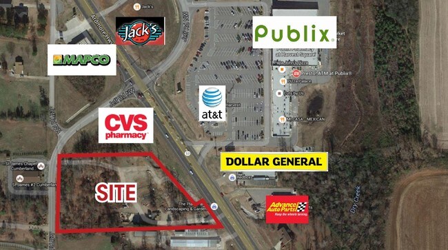

NEARBY LISTINGS FOR SALE OR LEASE
Property Detail
5825 Highway 53
Huntsville, AL
Little Burwell Estates
06-07-26-0-000-056.000
SEC 26 T2S R2W COMM AT THE NW COR OF SEC 26 TH E TO E ROW MAR FOR JEFF RD TH S'LY ALG SD ROW MAR 101.88 FT TO POB TH S'LY LAG
Commercialnec
Madison
X
Alabama
01089C0155F
2.51 AC
2025
North Madison County
2025
Huntsville
010504
DEMOGRAPHICS near 5825 Highway 53
1 Mile
3 Mile
5 Mile
2024 Total Population
2,894
16,248
43,300
2029 Population
3,217
18,008
48,146
Pop Growth 2024-2029
+ 11.16%
+ 10.83%
+ 11.19%
Average Age
38
39
40
2024 Total Households
1,034
5,910
15,903
HH Growth 2024-2029
+ 11.61%
+ 11.30%
+ 11.67%
Median Household Inc
$110,000
$118,487
$109,742
Avg Household Size
2.70
2.70
2.60
2024 Avg HH Vehicles
3.00
2.00
2.00
Median Home Value
$305,053
$290,444
$271,444
Median Year Built
2004
2002
2001
Nearby Places
Map Layers
Map Styles
 Street
 Aerial
- Restaurants
- Banks
- Shops
- Fitness
- Groceries
PUBLIC TRANSPORTATION
AIRPORT
Huntsville International-Carl T Jones Field
DRIVE
WALK
Distance
Huntsville International-Carl T Jones Field
28 min
19.3 mi
Freight Ports
Port of Mobile
DRIVE
WALK
Distance
Port of Mobile
395 min
360.5 mi
SALE & LEASE HISTORY
LISTING DATE
SALE/LEASE

Sep 24, 2016
For Sale
Jul 09, 2018
For Sale
Feb 18, 2020
For Sale
Dec 16, 2020
For Sale
Nearby Properties
Address
Land Use
TOTAL SIZE
Lot Size
Zoning
Address
Land Use
TOTAL SIZE
Lot Size
Zoning
14,544 SF
8.50 AC
Address
Land Use
TOTAL SIZE
Lot Size
Zoning
45,790 SF
13.39 AC
Address
Land Use
TOTAL SIZE
Lot Size
Zoning
Address
Land Use
TOTAL SIZE
Lot Size
Zoning
11,414 SF
7.60 AC
Address
Land Use
TOTAL SIZE
Lot Size
Zoning
22,990 SF
18 AC
Address
Land Use
TOTAL SIZE
Lot Size
Zoning
Address
Land Use
TOTAL SIZE
Lot Size
Zoning
10,882 SF
7.21 AC
Address
Land Use
TOTAL SIZE
Lot Size
Zoning
8,712 SF
1.55 AC
Address
Land Use
TOTAL SIZE
Lot Size
Zoning
24,300 SF
9.28 AC
Address
Land Use
TOTAL SIZE
Lot Size
Zoning
30,000 SF
3.40 AC
Address
Land Use
TOTAL SIZE
Lot Size
Zoning
6,967 SF
3.25 AC
Address
Land Use
TOTAL SIZE
Lot Size
Zoning
5,760 SF
3.40 AC
Address
Land Use
TOTAL SIZE
Lot Size
Zoning
11,743 SF
0.95 AC
Address
Land Use
TOTAL SIZE
Lot Size
Zoning
10,000 SF
2.78 AC
Address
Land Use
TOTAL SIZE
Lot Size
Zoning
11,243 SF
9.10 AC
Address
Land Use
TOTAL SIZE
Lot Size
Zoning
7,870 SF
2.17 AC
Address
Land Use
TOTAL SIZE
Lot Size
Zoning
3,679 SF
1.31 AC
Address
Land Use
TOTAL SIZE
Lot Size
Zoning
3,511 SF
1.12 AC
Address
Land Use
TOTAL SIZE
Lot Size
Zoning
3,440 SF
1.49 AC
Address
Land Use
TOTAL SIZE
Lot Size
Zoning
6,280 SF
4.93 AC
Address
Land Use
TOTAL SIZE
Lot Size
Zoning
2,400 SF
0.89 AC
Address
Land Use
TOTAL SIZE
Lot Size
Zoning
1,152 SF
35 AC
Address
Land Use
TOTAL SIZE
Lot Size
Zoning
9,100 SF
1.68 AC
Address
Land Use
TOTAL SIZE
Lot Size
Zoning
2,790 SF
1.04 AC
Address
Land Use
TOTAL SIZE
Lot Size
Zoning
4.89 AC
LRLI
Address
Land Use
TOTAL SIZE
Lot Size
Zoning
8,164 SF
6.50 AC
Address
Land Use
TOTAL SIZE
Lot Size
Zoning
Address
Land Use
TOTAL SIZE
Lot Size
Zoning
3,630 SF
1.09 AC
Address
Land Use
TOTAL SIZE
Lot Size
Zoning
5,151 SF
2.20 AC
The World's #1 Commercial Real Estate Marketplace
Connect with us
© 2026 CoStar Group
The information above has been obtained from sources believed reliable. While we do not doubt its accuracy we have not verified it and make no guarantee, warranty or representation about it. It is your responsibility to independently confirm its accuracy and completeness. Any projections, opinions, assumptions, or estimates used are for example only and do not represent the current or future performance of the property. The value of this transaction to you depends on tax and other factors which should be evaluated by your tax, financial, and legal advisors. You and your advisors should conduct a careful, independent investigation of the property to determine to your satisfaction the suitability of the property for your needs.