Property Record
5825 Oasis Ct, Redding, CA 96003
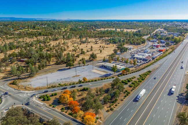
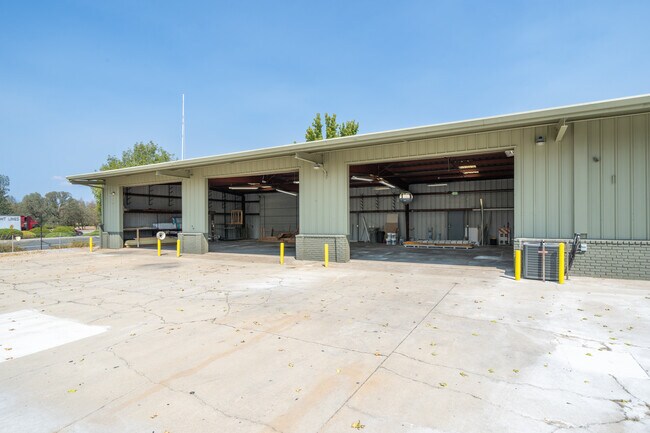
Property Detail
5825 Oasis Ct
Redding, CA
SHASTA
074-150-010-000
California
Commercialacreage
9
B and X Area of moderate flood hazard, usually the area between the limits of the 100-year and 500-year floods.
0.14 AC
2024
Redding/Chico
2025
Other Market Areas
0108072017
NEARBY LISTINGS FOR SALE OR LEASE
DEMOGRAPHICS near 5825 Oasis Ct
1 mile
3 mile
5 mile
2025 Total Population
1,590
30,634
66,476
2030 Population
1,606
30,782
66,703
Pop Growth 2025-2030
+ 1.01%
+ 0.48%
+ 0.34%
Average Age
43
42
42
2025 Total Households
598
12,707
27,641
HH Growth 2025-2030
+ 1.00%
+ 0.46%
+ 0.32%
Median Household Inc
$95,440
$70,539
$70,491
Avg Household Size
2.60
2.30
2.30
2025 Avg HH Vehicles
2.00
2.00
2.00
Median Home Value
$399,489
$329,008
$352,461
Median Year Built
1991
1985
1983
Nearby Places
Map Layers
Map Styles
 Street
 Aerial
Transit
 Traffic
 Biking
Places
Listings with unknown addresses are not visible on the map
- Restaurants
- Banks
- Shops
- Fitness
- Groceries
PUBLIC TRANSPORTATION
COMMUTER RAIL
Redding Amtrak (Coast Starlight - Amtrak)
Drive
Walk
Distance
Redding Amtrak (Coast Starlight - Amtrak)
8 min
6.1 mi
AIRPORT
Redding Regional
Drive
Walk
Distance
Redding Regional
15 min
12.0 mi
Freight Ports
Port of Richmond
Drive
Walk
Distance
Port of Richmond
233 min
208.3 mi
SALE & LEASE HISTORY
LISTING DATE
SALE/LEASE

Sep 25, 2022
For Sale
Nov 15, 2019
For Sale
Dec 07, 2020
For Lease
Nearby Properties
Address
Land Use
TOTAL SIZE
Lot Size
Zoning
Address
Land Use
TOTAL SIZE
Lot Size
Zoning
69.43 AC
Address
Land Use
TOTAL SIZE
Lot Size
Zoning
39.85 AC
Address
Land Use
TOTAL SIZE
Lot Size
Zoning
35.43 AC
Address
Land Use
TOTAL SIZE
Lot Size
Zoning
31,526 SF
55.92 AC
Address
Land Use
TOTAL SIZE
Lot Size
Zoning
1,500 SF
69.70 AC
Address
Land Use
TOTAL SIZE
Lot Size
Zoning
104,740 SF
23.54 AC
Address
Land Use
TOTAL SIZE
Lot Size
Zoning
54,811 SF
2.22 AC
Address
Land Use
TOTAL SIZE
Lot Size
Zoning
8,200 SF
55.72 AC
Address
Land Use
TOTAL SIZE
Lot Size
Zoning
39,290 SF
2.28 AC
Address
Land Use
TOTAL SIZE
Lot Size
Zoning
72,991 SF
4.25 AC
Address
Land Use
TOTAL SIZE
Lot Size
Zoning
20.85 AC
Address
Land Use
TOTAL SIZE
Lot Size
Zoning
7.89 AC
Address
Land Use
TOTAL SIZE
Lot Size
Zoning
14.81 AC
Address
Land Use
TOTAL SIZE
Lot Size
Zoning
38,868 SF
2.54 AC
Address
Land Use
TOTAL SIZE
Lot Size
Zoning
29,656 SF
3.18 AC
Address
Land Use
TOTAL SIZE
Lot Size
Zoning
46,420 SF
2.62 AC
Address
Land Use
TOTAL SIZE
Lot Size
Zoning
2,000 SF
5.29 AC
Address
Land Use
TOTAL SIZE
Lot Size
Zoning
37,940 SF
1.67 AC
Address
Land Use
TOTAL SIZE
Lot Size
Zoning
3.33 AC
Address
Land Use
TOTAL SIZE
Lot Size
Zoning
7.23 AC
Address
Land Use
TOTAL SIZE
Lot Size
Zoning
0.87 AC
Address
Land Use
TOTAL SIZE
Lot Size
Zoning
12,261 SF
19.69 AC
Address
Land Use
TOTAL SIZE
Lot Size
Zoning
70,000 SF
5.10 AC
Address
Land Use
TOTAL SIZE
Lot Size
Zoning
45,050 SF
5.95 AC
Address
Land Use
TOTAL SIZE
Lot Size
Zoning
17,422 SF
1.71 AC
Address
Land Use
TOTAL SIZE
Lot Size
Zoning
60,738 SF
6.12 AC
Address
Land Use
TOTAL SIZE
Lot Size
Zoning
70,000 SF
10.11 AC
Address
Land Use
TOTAL SIZE
Lot Size
Zoning
3,321 SF
12.02 AC
Address
Land Use
TOTAL SIZE
Lot Size
Zoning
2,820 SF
5.50 AC
Address
Land Use
TOTAL SIZE
Lot Size
Zoning
90,020 SF
8.24 AC
The World's #1 Commercial Real Estate Marketplace
Connect with us
© 2026 CoStar Group
The information above has been obtained from sources believed reliable. While we do not doubt its accuracy we have not verified it and make no guarantee, warranty or representation about it. It is your responsibility to independently confirm its accuracy and completeness. Any projections, opinions, assumptions, or estimates used are for example only and do not represent the current or future performance of the property. The value of this transaction to you depends on tax and other factors which should be evaluated by your tax, financial, and legal advisors. You and your advisors should conduct a careful, independent investigation of the property to determine to your satisfaction the suitability of the property for your needs.