Property Record
5827 Mckinley Rd, Brewerton, NY 13029
NEARBY LISTINGS FOR SALE OR LEASE
Property Detail
5827 Mckinley Rd
312289-099-000-0001-031-002-0000
Onondaga
Privateutilityelectricwatergasnuclearsolarwindetc
New York
X
31.002
36067C0103F
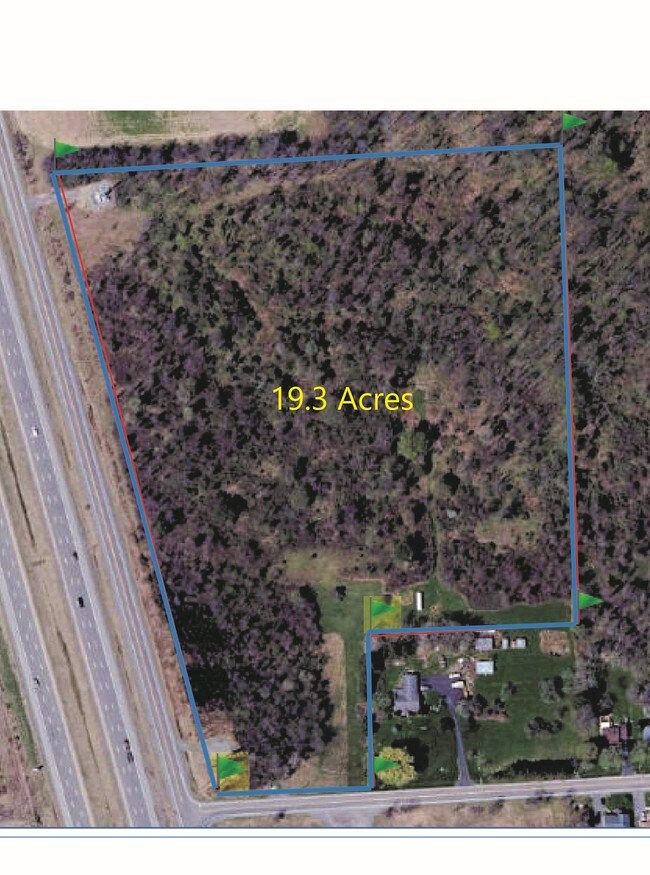
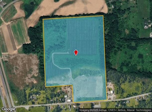
56.89 AC
2025
NE Outer Onondaga County
2024
Syracuse
010200
Syracuse, NY
3,724 SF
DEMOGRAPHICS near 5827 Mckinley Rd
1 mile
3 mile
5 mile
2024 Total Population
1,833
24,811
50,232
2029 Population
1,771
24,066
48,843
Pop Growth 2024-2029
(3.38%)
(3.00%)
(2.77%)
Average Age
43
41
42
2024 Total Households
723
9,701
20,508
HH Growth 2024-2029
(3.60%)
(3.26%)
(2.95%)
Median Household Inc
$109,786
$100,642
$87,625
Avg Household Size
2.50
2.50
2.40
2024 Avg HH Vehicles
2.00
2.00
2.00
Median Home Value
$174,685
$189,007
$180,506
Median Year Built
1983
1983
1974
Nearby Places
Map Layers
Map Styles
 Street
 Aerial
Transit
 Traffic
 Biking
Places
Listings with unknown addresses are not visible on the map
- Restaurants
- Banks
- Shops
- Fitness
- Groceries
PUBLIC TRANSPORTATION
AIRPORT
Syracuse Hancock International
Drive
Walk
Distance
Syracuse Hancock International
14 min
8.0 mi
Freight Ports
Albany, NY Port
Drive
Walk
Distance
Albany, NY Port
179 min
148.3 mi
SALE & LEASE HISTORY
LISTING DATE
SALE/LEASE

Mar 19, 2019
For Sale
Nearby Properties
Address
Land Use
TOTAL SIZE
Lot Size
Zoning
Address
Land Use
TOTAL SIZE
Lot Size
Zoning
256,727 SF
70.21 AC
Address
Land Use
TOTAL SIZE
Lot Size
Zoning
157,010 SF
36.98 AC
Address
Land Use
TOTAL SIZE
Lot Size
Zoning
203,345 SF
18.17 AC
Address
Land Use
TOTAL SIZE
Lot Size
Zoning
8,417 SF
13.95 AC
Address
Land Use
TOTAL SIZE
Lot Size
Zoning
24,556 SF
16.52 AC
Address
Land Use
TOTAL SIZE
Lot Size
Zoning
125,400 SF
18.11 AC
GC
Address
Land Use
TOTAL SIZE
Lot Size
Zoning
92,844 SF
14.26 AC
C-G
Address
Land Use
TOTAL SIZE
Lot Size
Zoning
1,568 SF
330.36 AC
Address
Land Use
TOTAL SIZE
Lot Size
Zoning
103,005 SF
12.58 AC
Address
Land Use
TOTAL SIZE
Lot Size
Zoning
66,538 SF
18.24 AC
Address
Land Use
TOTAL SIZE
Lot Size
Zoning
81,439 SF
15.48 AC
Address
Land Use
TOTAL SIZE
Lot Size
Zoning
57,052 SF
16.82 AC
Address
Land Use
TOTAL SIZE
Lot Size
Zoning
39,128 SF
17.22 AC
Address
Land Use
TOTAL SIZE
Lot Size
Zoning
2,404 SF
9.73 AC
Address
Land Use
TOTAL SIZE
Lot Size
Zoning
29,745 SF
31.63 AC
Address
Land Use
TOTAL SIZE
Lot Size
Zoning
42,698 SF
13.85 AC
Address
Land Use
TOTAL SIZE
Lot Size
Zoning
271,263 SF
77.30 AC
Address
Land Use
TOTAL SIZE
Lot Size
Zoning
17,436 SF
98.89 AC
06000
Address
Land Use
TOTAL SIZE
Lot Size
Zoning
8,224 SF
8.45 AC
PUD-R
Address
Land Use
TOTAL SIZE
Lot Size
Zoning
8,224 SF
9.86 AC
PUD-R
Address
Land Use
TOTAL SIZE
Lot Size
Zoning
16,630 SF
10.16 AC
Address
Land Use
TOTAL SIZE
Lot Size
Zoning
15,696 SF
26.92 AC
PUD-R
Address
Land Use
TOTAL SIZE
Lot Size
Zoning
900 SF
0.44 AC
R-10
Address
Land Use
TOTAL SIZE
Lot Size
Zoning
43,968 SF
1.95 AC
Address
Land Use
TOTAL SIZE
Lot Size
Zoning
12,220 SF
5.86 AC
Address
Land Use
TOTAL SIZE
Lot Size
Zoning
7,416 SF
7.30 AC
Address
Land Use
TOTAL SIZE
Lot Size
Zoning
74,342 SF
8.81 AC
Address
Land Use
TOTAL SIZE
Lot Size
Zoning
26,724 SF
89.15 AC
Address
Land Use
TOTAL SIZE
Lot Size
Zoning
116,020 SF
15.72 AC
PUD
The World's #1 Commercial Real Estate Marketplace
Connect with us
© 2026 CoStar Group
The information above has been obtained from sources believed reliable. While we do not doubt its accuracy we have not verified it and make no guarantee, warranty or representation about it. It is your responsibility to independently confirm its accuracy and completeness. Any projections, opinions, assumptions, or estimates used are for example only and do not represent the current or future performance of the property. The value of this transaction to you depends on tax and other factors which should be evaluated by your tax, financial, and legal advisors. You and your advisors should conduct a careful, independent investigation of the property to determine to your satisfaction the suitability of the property for your needs.