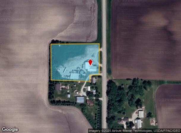
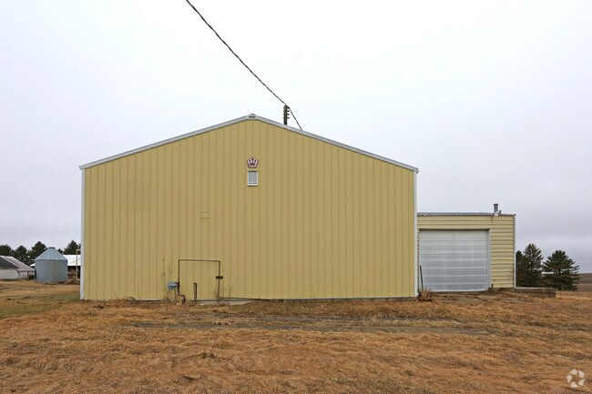
Property Record
58289 280Th Ave, Mantorville, MN 55955

NEARBY LISTINGS FOR SALE OR LEASE
-
-
View all Mantorville listings for sale on LoopNet.com
Property Detail
58289 280Th Ave
Commercialnec
89700 0 SECT-01 TWP-107 RANGE-016 4.00 AC 4.00 ACRES - COMM NECOR NE1/4 TH S ALONG E LINE OF SD NE1/4 1319.76FT TO PT OF BEG,
X
Dodge
27039C0200C
Minnesota
2025
4 AC
2025
Other Market Areas
950100
Rochester, MN
6,032 SF
13.001.0200
DEMOGRAPHICS near 58289 280Th Ave
1 Mile
3 Mile
5 Mile
2024 Total Population
77
587
6,969
2029 Population
78
596
7,062
Pop Growth 2024-2029
+ 1.30%
+ 1.53%
+ 1.33%
Average Age
42
41
39
2024 Total Households
27
207
2,431
HH Growth 2024-2029
+ 3.70%
+ 1.45%
+ 1.28%
Median Household Inc
$109,375
$110,483
$124,305
Avg Household Size
2.70
2.80
2.80
2024 Avg HH Vehicles
3.00
3.00
3.00
Median Home Value
$368,749
$375,806
$360,942
Median Year Built
1978
1982
1995
Nearby Places
Map Layers
Map Styles
 Street
 Aerial
- Restaurants
- Banks
- Shops
- Fitness
- Groceries
PUBLIC TRANSPORTATION
AIRPORT
Rochester International
DRIVE
WALK
Distance
Rochester International
32 min
22.7 mi
Freight Ports
Port Milwaukee
DRIVE
WALK
Distance
Port Milwaukee
325 min
292.1 mi
SALE & LEASE HISTORY
LISTING DATE
SALE/LEASE

Apr 04, 2017
For Sale
Nearby Properties
Address
Land Use
TOTAL SIZE
Lot Size
Zoning
Address
Land Use
TOTAL SIZE
Lot Size
Zoning
14,100 SF
23.50 AC
Address
Land Use
TOTAL SIZE
Lot Size
Zoning
271.13 AC
Address
Land Use
TOTAL SIZE
Lot Size
Zoning
151.74 AC
Address
Land Use
TOTAL SIZE
Lot Size
Zoning
178.08 AC
Address
Land Use
TOTAL SIZE
Lot Size
Zoning
1,017 SF
120 AC
Address
Land Use
TOTAL SIZE
Lot Size
Zoning
Address
Land Use
TOTAL SIZE
Lot Size
Zoning
1,120 SF
160 AC
Address
Land Use
TOTAL SIZE
Lot Size
Zoning
Address
Land Use
TOTAL SIZE
Lot Size
Zoning
196.30 AC
Address
Land Use
TOTAL SIZE
Lot Size
Zoning
152.19 AC
Address
Land Use
TOTAL SIZE
Lot Size
Zoning
144.27 AC
Address
Land Use
TOTAL SIZE
Lot Size
Zoning
Address
Land Use
TOTAL SIZE
Lot Size
Zoning
Address
Land Use
TOTAL SIZE
Lot Size
Zoning
Address
Land Use
TOTAL SIZE
Lot Size
Zoning
99.42 AC
Address
Land Use
TOTAL SIZE
Lot Size
Zoning
111.60 AC
Address
Land Use
TOTAL SIZE
Lot Size
Zoning
1,456 SF
80 AC
Address
Land Use
TOTAL SIZE
Lot Size
Zoning
Address
Land Use
TOTAL SIZE
Lot Size
Zoning
Address
Land Use
TOTAL SIZE
Lot Size
Zoning
74.15 AC
Address
Land Use
TOTAL SIZE
Lot Size
Zoning
Address
Land Use
TOTAL SIZE
Lot Size
Zoning
106.09 AC
Address
Land Use
TOTAL SIZE
Lot Size
Zoning
66.38 AC
Address
Land Use
TOTAL SIZE
Lot Size
Zoning
Address
Land Use
TOTAL SIZE
Lot Size
Zoning
65.07 AC
Address
Land Use
TOTAL SIZE
Lot Size
Zoning
952 SF
40.07 AC
Address
Land Use
TOTAL SIZE
Lot Size
Zoning
93.75 AC
Address
Land Use
TOTAL SIZE
Lot Size
Zoning
74.17 AC
Address
Land Use
TOTAL SIZE
Lot Size
Zoning
1,904 SF
66.40 AC
Address
Land Use
TOTAL SIZE
Lot Size
Zoning
The World's #1 Commercial Real Estate Marketplace
Connect with us
© 2025 CoStar Group
The information above has been obtained from sources believed reliable. While we do not doubt its accuracy we have not verified it and make no guarantee, warranty or representation about it. It is your responsibility to independently confirm its accuracy and completeness. Any projections, opinions, assumptions, or estimates used are for example only and do not represent the current or future performance of the property. The value of this transaction to you depends on tax and other factors which should be evaluated by your tax, financial, and legal advisors. You and your advisors should conduct a careful, independent investigation of the property to determine to your satisfaction the suitability of the property for your needs.