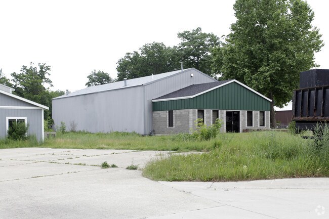
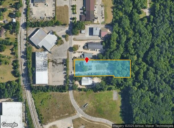
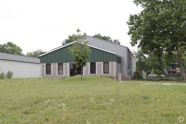
Property Record
5830 Comstock Park Dr Nw, Comstock Park, MI 49321
NEARBY LISTINGS FOR SALE OR LEASE
Property Detail
5830 Comstock Park Dr Nw
41-09-24-127-029
PART OF NW 1/4 COM 1023.08 FT S 0D 04M W ALONG N&S 1/4 LINE FROM N 1/4 COR TH N 89D 59M W 562.20 FT TH S 0D 01M W 155.0 FT TH
Manufacturinglight
Kent
X
Michigan
26081C0285D
1.93 AC
2024
Comstock/Alpine
2025
West Michigan
011401
Grand Rapids-Wyoming, MI
4,228 SF
DEMOGRAPHICS near 5830 Comstock Park Dr Nw
1 Mile
3 Mile
5 Mile
2024 Total Population
1,818
19,812
64,006
2029 Population
1,809
19,935
64,375
Pop Growth 2024-2029
(0.50%)
+ 0.62%
+ 0.58%
Average Age
42
39
40
2024 Total Households
717
8,147
26,090
HH Growth 2024-2029
(0.42%)
+ 0.64%
+ 0.59%
Median Household Inc
$59,023
$63,103
$71,816
Avg Household Size
2.50
2.40
2.40
2024 Avg HH Vehicles
2.00
2.00
2.00
Median Home Value
$236,331
$242,473
$240,754
Median Year Built
1980
1985
1977
Nearby Places
Map Layers
Map Styles
 Street
 Aerial
- Restaurants
- Banks
- Shops
- Fitness
- Groceries
PUBLIC TRANSPORTATION
COMMUTER RAIL
DRIVE
WALK
Distance
16 min
10.0 mi
AIRPORT
Gerald R Ford International
DRIVE
WALK
Distance
Gerald R Ford International
34 min
22.5 mi
Nearby Properties
Address
Land Use
TOTAL SIZE
Lot Size
Zoning
Address
Land Use
TOTAL SIZE
Lot Size
Zoning
169,898 SF
Address
Land Use
TOTAL SIZE
Lot Size
Zoning
33.06 AC
R-3
Address
Land Use
TOTAL SIZE
Lot Size
Zoning
Address
Land Use
TOTAL SIZE
Lot Size
Zoning
32.63 AC
R-3
Address
Land Use
TOTAL SIZE
Lot Size
Zoning
Address
Land Use
TOTAL SIZE
Lot Size
Zoning
169,926 SF
8.52 AC
C-2
Address
Land Use
TOTAL SIZE
Lot Size
Zoning
Address
Land Use
TOTAL SIZE
Lot Size
Zoning
239,172 SF
25.79 AC
C-2
Address
Land Use
TOTAL SIZE
Lot Size
Zoning
9.11 AC
R-3
Address
Land Use
TOTAL SIZE
Lot Size
Zoning
8.77 AC
R-3
Address
Land Use
TOTAL SIZE
Lot Size
Zoning
221,081 SF
22.91 AC
C-2
Address
Land Use
TOTAL SIZE
Lot Size
Zoning
11.86 AC
R-3
Address
Land Use
TOTAL SIZE
Lot Size
Zoning
91,434 SF
14.22 AC
CPUD
Address
Land Use
TOTAL SIZE
Lot Size
Zoning
10.48 AC
R-3
Address
Land Use
TOTAL SIZE
Lot Size
Zoning
13.22 AC
R-3
Address
Land Use
TOTAL SIZE
Lot Size
Zoning
100,800 SF
I-1
Address
Land Use
TOTAL SIZE
Lot Size
Zoning
Address
Land Use
TOTAL SIZE
Lot Size
Zoning
2,676 SF
12.32 AC
R-3
Address
Land Use
TOTAL SIZE
Lot Size
Zoning
11.39 AC
R-3
Address
Land Use
TOTAL SIZE
Lot Size
Zoning
Address
Land Use
TOTAL SIZE
Lot Size
Zoning
117,225 SF
22.01 AC
I-1
Address
Land Use
TOTAL SIZE
Lot Size
Zoning
171,155 SF
14.47 AC
I-2
Address
Land Use
TOTAL SIZE
Lot Size
Zoning
138,105 SF
18.27 AC
C-2
Address
Land Use
TOTAL SIZE
Lot Size
Zoning
10.85 AC
R-3
Address
Land Use
TOTAL SIZE
Lot Size
Zoning
53.97 AC
Address
Land Use
TOTAL SIZE
Lot Size
Zoning
16.45 AC
Address
Land Use
TOTAL SIZE
Lot Size
Zoning
20.20 AC
Address
Land Use
TOTAL SIZE
Lot Size
Zoning
97,078 SF
10.67 AC
C-PUD
Address
Land Use
TOTAL SIZE
Lot Size
Zoning
9.71 AC
R-3
Address
Land Use
TOTAL SIZE
Lot Size
Zoning
44,455 SF
6.77 AC
I-1
The World's #1 Commercial Real Estate Marketplace
Connect with us
© 2025 CoStar Group
The information above has been obtained from sources believed reliable. While we do not doubt its accuracy we have not verified it and make no guarantee, warranty or representation about it. It is your responsibility to independently confirm its accuracy and completeness. Any projections, opinions, assumptions, or estimates used are for example only and do not represent the current or future performance of the property. The value of this transaction to you depends on tax and other factors which should be evaluated by your tax, financial, and legal advisors. You and your advisors should conduct a careful, independent investigation of the property to determine to your satisfaction the suitability of the property for your needs.