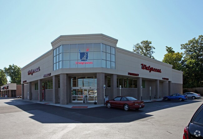
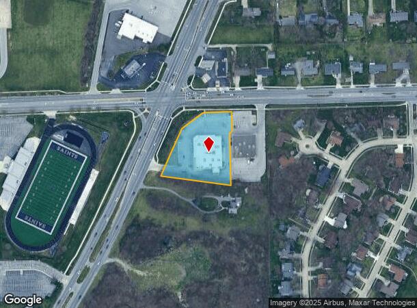
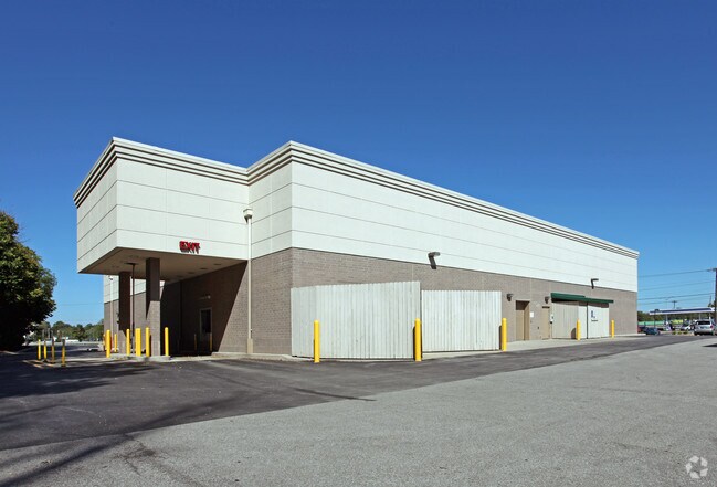
Property Record
5830 N Clinton St, Fort Wayne, IN 46825
NEARBY LISTINGS FOR SALE OR LEASE
Property Detail
5830 N Clinton St
02-07-24-226-001.000-073
1.59 A IRR TRACT NE 1/4 SEC 24 @ INT OF CLINTON ST & ST JOE CENTER RD
Storebuilding
Allen
X
Indiana
18003C0188G
1.59 AC
2023
North Fort Wayne
2024
Fort Wayne
004103
Fort Wayne, IN
15,048 SF
DEMOGRAPHICS near 5830 N Clinton St
1 Mile
3 Mile
5 Mile
2024 Total Population
10,554
69,987
177,595
2029 Population
10,954
72,908
185,034
Pop Growth 2024-2029
+ 3.79%
+ 4.17%
+ 4.19%
Average Age
37
38
38
2024 Total Households
4,782
29,837
73,246
HH Growth 2024-2029
+ 3.83%
+ 4.29%
+ 4.33%
Median Household Inc
$53,365
$58,134
$59,235
Avg Household Size
2.10
2.20
2.30
2024 Avg HH Vehicles
2.00
2.00
2.00
Median Home Value
$132,143
$149,466
$159,993
Median Year Built
1975
1972
1975
Nearby Places
Map Layers
Map Styles
 Street
 Aerial
- Restaurants
- Banks
- Shops
- Fitness
- Groceries
PUBLIC TRANSPORTATION
AIRPORT
Fort Wayne International
DRIVE
WALK
Distance
Fort Wayne International
28 min
14.9 mi
Freight Ports
Port of Toledo
DRIVE
WALK
Distance
Port of Toledo
139 min
102.9 mi
SALE & LEASE HISTORY
LISTING DATE
SALE/LEASE

May 23, 2018
For Sale
Jan 28, 2019
For Sale
Nearby Properties
Address
Land Use
TOTAL SIZE
Lot Size
Zoning
Address
Land Use
TOTAL SIZE
Lot Size
Zoning
460,252 SF
47.79 AC
Address
Land Use
TOTAL SIZE
Lot Size
Zoning
921,633 SF
18.04 AC
Address
Land Use
TOTAL SIZE
Lot Size
Zoning
435,615 SF
16.03 AC
Address
Land Use
TOTAL SIZE
Lot Size
Zoning
242,556 SF
17.18 AC
Address
Land Use
TOTAL SIZE
Lot Size
Zoning
855,487 SF
102.83 AC
Address
Land Use
TOTAL SIZE
Lot Size
Zoning
702,400 SF
40.69 AC
Address
Land Use
TOTAL SIZE
Lot Size
Zoning
129,080 SF
15.77 AC
Address
Land Use
TOTAL SIZE
Lot Size
Zoning
401,523 SF
27.35 AC
Address
Land Use
TOTAL SIZE
Lot Size
Zoning
344,490 SF
195.62 AC
Address
Land Use
TOTAL SIZE
Lot Size
Zoning
59,089 SF
28.68 AC
Address
Land Use
TOTAL SIZE
Lot Size
Zoning
68,817 SF
14.26 AC
Address
Land Use
TOTAL SIZE
Lot Size
Zoning
344,973 SF
37.85 AC
Address
Land Use
TOTAL SIZE
Lot Size
Zoning
171,121 SF
15.40 AC
Address
Land Use
TOTAL SIZE
Lot Size
Zoning
75,690 SF
26.84 AC
Address
Land Use
TOTAL SIZE
Lot Size
Zoning
32,189 SF
9.64 AC
Address
Land Use
TOTAL SIZE
Lot Size
Zoning
222,349 SF
32.27 AC
Address
Land Use
TOTAL SIZE
Lot Size
Zoning
248,016 SF
50.67 AC
Address
Land Use
TOTAL SIZE
Lot Size
Zoning
295,073 SF
26.25 AC
Address
Land Use
TOTAL SIZE
Lot Size
Zoning
58,913 SF
22.64 AC
Address
Land Use
TOTAL SIZE
Lot Size
Zoning
161,200 SF
8 AC
Address
Land Use
TOTAL SIZE
Lot Size
Zoning
257,006 SF
24.21 AC
Address
Land Use
TOTAL SIZE
Lot Size
Zoning
250,021 SF
2.25 AC
Address
Land Use
TOTAL SIZE
Lot Size
Zoning
85,484 SF
11.61 AC
Address
Land Use
TOTAL SIZE
Lot Size
Zoning
126,957 SF
21.27 AC
Address
Land Use
TOTAL SIZE
Lot Size
Zoning
132,340 SF
21.46 AC
Address
Land Use
TOTAL SIZE
Lot Size
Zoning
206,522 SF
13 AC
Address
Land Use
TOTAL SIZE
Lot Size
Zoning
154,701 SF
15.33 AC
Address
Land Use
TOTAL SIZE
Lot Size
Zoning
255,864 SF
10.70 AC
Address
Land Use
TOTAL SIZE
Lot Size
Zoning
52,910 SF
4.91 AC
Address
Land Use
TOTAL SIZE
Lot Size
Zoning
188,270 SF
22.50 AC
The World's #1 Commercial Real Estate Marketplace
Connect with us
© 2025 CoStar Group
The information above has been obtained from sources believed reliable. While we do not doubt its accuracy we have not verified it and make no guarantee, warranty or representation about it. It is your responsibility to independently confirm its accuracy and completeness. Any projections, opinions, assumptions, or estimates used are for example only and do not represent the current or future performance of the property. The value of this transaction to you depends on tax and other factors which should be evaluated by your tax, financial, and legal advisors. You and your advisors should conduct a careful, independent investigation of the property to determine to your satisfaction the suitability of the property for your needs.