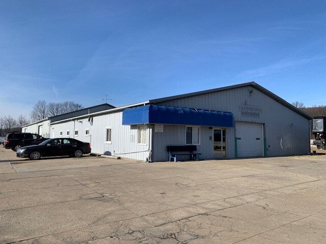
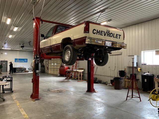
Property Record
5832 County Line Rd, Lenox, MI 48048

NEARBY LISTINGS FOR SALE OR LEASE
-
-
View all Lenox listings for sale on LoopNet.com
Property Detail
5832 County Line Rd
19-06-36-400-015
T4N R14E PT OF SE 1/4 SEC 36 DESC AS; BEG AT A PT ON E/L SEC 36 S00*30'00E 333.0 FT FR E 1/4 COR SEC 36;TH S00*30'00"E ALG
Commercialnec
Macomb
X
Michigan
26147C0476D
6.35 AC
2025
St Clair & Lapeer Counties
2025
Detroit
218002
Detroit-Warren-Dearborn, MI
1,726 SF
DEMOGRAPHICS near 5832 County Line Rd
1 Mile
3 Mile
5 Mile
2024 Total Population
2,371
19,747
48,429
2029 Population
2,406
19,788
48,353
Pop Growth 2024-2029
+ 1.48%
+ 0.21%
(0.16%)
Average Age
40
39
40
2024 Total Households
639
6,414
17,491
HH Growth 2024-2029
+ 2.35%
+ 0.30%
(0.13%)
Median Household Inc
$53,095
$78,755
$80,289
Avg Household Size
2.60
2.80
2.60
2024 Avg HH Vehicles
2.00
2.00
2.00
Median Home Value
$81,369
$234,540
$251,689
Median Year Built
1998
1999
1995
Nearby Places
Map Layers
Map Styles
 Street
 Aerial
- Restaurants
- Banks
- Shops
- Fitness
- Groceries
PUBLIC TRANSPORTATION
AIRPORT
Windsor International
DRIVE
WALK
Distance
Windsor International
69 min
46.5 mi
SALE & LEASE HISTORY
LISTING DATE
SALE/LEASE

Jan 05, 2023
For Sale
Nearby Properties
Address
Land Use
TOTAL SIZE
Lot Size
Zoning
Address
Land Use
TOTAL SIZE
Lot Size
Zoning
115,695 SF
Address
Land Use
TOTAL SIZE
Lot Size
Zoning
2,520 SF
712.24 AC
AG
Address
Land Use
TOTAL SIZE
Lot Size
Zoning
210,688 SF
20.13 AC
CG
Address
Land Use
TOTAL SIZE
Lot Size
Zoning
7,262 SF
127.87 AC
MH
Address
Land Use
TOTAL SIZE
Lot Size
Zoning
276,497 SF
31.19 AC
I-1
Address
Land Use
TOTAL SIZE
Lot Size
Zoning
89,620 SF
17.89 AC
Address
Land Use
TOTAL SIZE
Lot Size
Zoning
60,123 SF
120 AC
I-2
Address
Land Use
TOTAL SIZE
Lot Size
Zoning
3,799 SF
56.46 AC
MH
Address
Land Use
TOTAL SIZE
Lot Size
Zoning
176,142 SF
21.95 AC
IND
Address
Land Use
TOTAL SIZE
Lot Size
Zoning
26,578 SF
31.52 AC
IR
Address
Land Use
TOTAL SIZE
Lot Size
Zoning
49,600 SF
14.50 AC
I-2
Address
Land Use
TOTAL SIZE
Lot Size
Zoning
10,297 SF
1.91 AC
AG
Address
Land Use
TOTAL SIZE
Lot Size
Zoning
15,788 SF
4.28 AC
CG
Address
Land Use
TOTAL SIZE
Lot Size
Zoning
21,944 SF
131.37 AC
CG
Address
Land Use
TOTAL SIZE
Lot Size
Zoning
3,418 SF
60 AC
CG
Address
Land Use
TOTAL SIZE
Lot Size
Zoning
3,927 SF
85.22 AC
MF
Address
Land Use
TOTAL SIZE
Lot Size
Zoning
26,578 SF
22.50 AC
Address
Land Use
TOTAL SIZE
Lot Size
Zoning
7.93 AC
I-1
Address
Land Use
TOTAL SIZE
Lot Size
Zoning
80,600 SF
6.52 AC
I-2
Address
Land Use
TOTAL SIZE
Lot Size
Zoning
56,505 SF
I-1
Address
Land Use
TOTAL SIZE
Lot Size
Zoning
68,000 SF
10.54 AC
CC
Address
Land Use
TOTAL SIZE
Lot Size
Zoning
5,682 SF
47.12 AC
RT
Address
Land Use
TOTAL SIZE
Lot Size
Zoning
13,145 SF
4.05 AC
GB
Address
Land Use
TOTAL SIZE
Lot Size
Zoning
45 AC
RT
Address
Land Use
TOTAL SIZE
Lot Size
Zoning
15,042 SF
2.08 AC
GB
Address
Land Use
TOTAL SIZE
Lot Size
Zoning
2,920 SF
47.73 AC
CN
Address
Land Use
TOTAL SIZE
Lot Size
Zoning
88,925 SF
7.49 AC
GC
Address
Land Use
TOTAL SIZE
Lot Size
Zoning
Address
Land Use
TOTAL SIZE
Lot Size
Zoning
35,352 SF
3.26 AC
RM-2
Address
Land Use
TOTAL SIZE
Lot Size
Zoning
14,744 SF
1.94 AC
CG
The World's #1 Commercial Real Estate Marketplace
Connect with us
© 2025 CoStar Group
The information above has been obtained from sources believed reliable. While we do not doubt its accuracy we have not verified it and make no guarantee, warranty or representation about it. It is your responsibility to independently confirm its accuracy and completeness. Any projections, opinions, assumptions, or estimates used are for example only and do not represent the current or future performance of the property. The value of this transaction to you depends on tax and other factors which should be evaluated by your tax, financial, and legal advisors. You and your advisors should conduct a careful, independent investigation of the property to determine to your satisfaction the suitability of the property for your needs.