Property Record
5834 Panama St, Cincinnati, OH 45230

Save to a Folder
{{folder.Name}}
{{folder.ListingIds.length}} Properties
{{folder.ListingIds.length}} Property
Create a New Folder
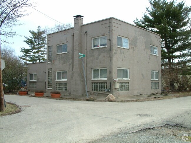
Property Detail
5834 Panama St
008-0001-0068
PANAMA ST 88 X 100 IR GUTHRIE ET AL SUB BLK 6 PRS 68-69-95 CONS
Multifamilydwelling
Hamilton
RFR
Ohio
AE The base floodplain where base flood elevations are provided. AE Zones are now used on new format FIRMs instead of A1-A30 Zones.
0.37 AC
2025
Eastgate/Anderson Twp
2025
Cincinnati/Dayton
027500
Cincinnati, OH-KY-IN
3,422 SF
NEARBY LISTINGS FOR SALE OR LEASE
DEMOGRAPHICS near 5834 Panama St
1 mile
3 mile
5 mile
2025 Total Population
1,641
44,424
159,019
2030 Population
1,657
44,808
161,513
Pop Growth 2025-2030
+ 0.98%
+ 0.86%
+ 1.57%
Average Age
42
40
40
2025 Total Households
643
18,872
70,520
HH Growth 2025-2030
+ 0.93%
+ 0.91%
+ 1.74%
Median Household Inc
$104,049
$83,570
$79,819
Avg Household Size
2.50
2.30
2.20
2025 Avg HH Vehicles
2.00
2.00
2.00
Median Home Value
$376,363
$266,016
$278,744
Median Year Built
1954
1964
1959
Nearby Places
Map Layers
Map Styles
 Street
 Aerial
Layers
 Traffic
 Biking
Places
Listings with unknown addresses are not visible on the map
- Restaurants
- Banks
- Shops
- Fitness
- Groceries
PUBLIC TRANSPORTATION
AIRPORT
Cincinnati/Northern Kentucky International
Drive
Walk
Distance
Cincinnati/Northern Kentucky International
29 min
16.9 mi
Freight Ports
Port of Toledo
Drive
Walk
Distance
Port of Toledo
254 min
212.6 mi
SALE & LEASE HISTORY
LISTING DATE
SALE/LEASE

Nov 08, 2017
For Sale
Nearby Properties
Address
Land Use
TOTAL SIZE
Lot Size
Zoning
Address
Land Use
TOTAL SIZE
Lot Size
Zoning
243,000 SF
11.30 AC
Address
Land Use
TOTAL SIZE
Lot Size
Zoning
411,750 SF
21.25 AC
Address
Land Use
TOTAL SIZE
Lot Size
Zoning
567,000 SF
183.83 AC
Address
Land Use
TOTAL SIZE
Lot Size
Zoning
1,049,050 SF
8.60 AC
Address
Land Use
TOTAL SIZE
Lot Size
Zoning
165,016 SF
15.23 AC
Address
Land Use
TOTAL SIZE
Lot Size
Zoning
21,600 SF
98.32 AC
Address
Land Use
TOTAL SIZE
Lot Size
Zoning
12,150 SF
10.02 AC
Address
Land Use
TOTAL SIZE
Lot Size
Zoning
60,772 SF
0.78 AC
Address
Land Use
TOTAL SIZE
Lot Size
Zoning
20.01 AC
Address
Land Use
TOTAL SIZE
Lot Size
Zoning
15,570 SF
21.35 AC
Address
Land Use
TOTAL SIZE
Lot Size
Zoning
46,600 SF
52.47 AC
Address
Land Use
TOTAL SIZE
Lot Size
Zoning
18,288 SF
41.21 AC
Address
Land Use
TOTAL SIZE
Lot Size
Zoning
2,837 SF
3.77 AC
Address
Land Use
TOTAL SIZE
Lot Size
Zoning
385,100 SF
4.60 AC
Address
Land Use
TOTAL SIZE
Lot Size
Zoning
Address
Land Use
TOTAL SIZE
Lot Size
Zoning
66,540 SF
4 AC
Address
Land Use
TOTAL SIZE
Lot Size
Zoning
89,925 SF
1.72 AC
Address
Land Use
TOTAL SIZE
Lot Size
Zoning
24,572 SF
4.70 AC
Address
Land Use
TOTAL SIZE
Lot Size
Zoning
22,188 SF
8.88 AC
Address
Land Use
TOTAL SIZE
Lot Size
Zoning
3,726,400 SF
12.60 AC
Address
Land Use
TOTAL SIZE
Lot Size
Zoning
173,940 SF
22.52 AC
Address
Land Use
TOTAL SIZE
Lot Size
Zoning
33,468 SF
1.04 AC
Address
Land Use
TOTAL SIZE
Lot Size
Zoning
29,264 SF
22.18 AC
Address
Land Use
TOTAL SIZE
Lot Size
Zoning
9,515 SF
19.13 AC
Address
Land Use
TOTAL SIZE
Lot Size
Zoning
Address
Land Use
TOTAL SIZE
Lot Size
Zoning
14.20 AC
Address
Land Use
TOTAL SIZE
Lot Size
Zoning
65,326 SF
9.71 AC
Address
Land Use
TOTAL SIZE
Lot Size
Zoning
30,100 SF
30.28 AC
Address
Land Use
TOTAL SIZE
Lot Size
Zoning
165,000 SF
Address
Land Use
TOTAL SIZE
Lot Size
Zoning
3,200 SF
14 AC
The World's #1 Commercial Real Estate Marketplace
Connect with us
© 2026 CoStar Group
The information above has been obtained from sources believed reliable. While we do not doubt its accuracy we have not verified it and make no guarantee, warranty or representation about it. It is your responsibility to independently confirm its accuracy and completeness. Any projections, opinions, assumptions, or estimates used are for example only and do not represent the current or future performance of the property. The value of this transaction to you depends on tax and other factors which should be evaluated by your tax, financial, and legal advisors. You and your advisors should conduct a careful, independent investigation of the property to determine to your satisfaction the suitability of the property for your needs.