Property Record
5835 N Highway 231, Panama City, FL 32404
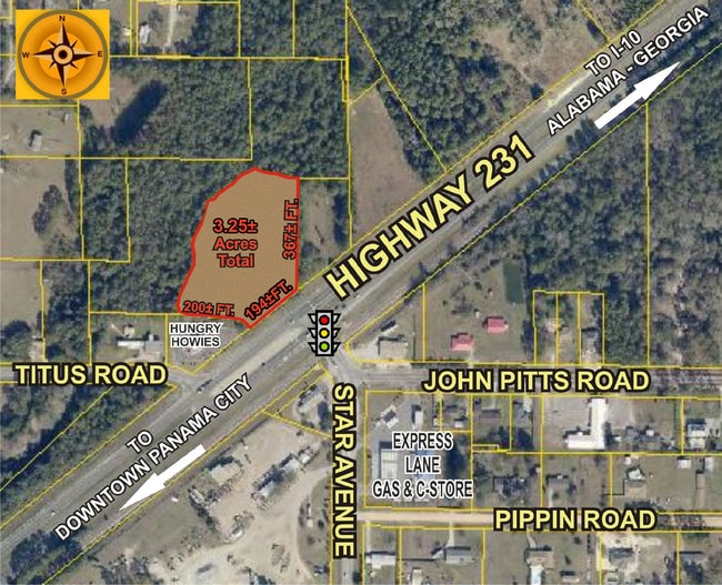


This Property Is For Sale
NEARBY LISTINGS FOR SALE OR LEASE
-
-
View all Panama City listings for sale on LoopNet.com
Property Detail
5835 N Highway 231
Panama City, FL
St And Bay Dev Co Plat
05816-000-000
5 3S 13W -7- 128A ST AND BAY DEV CO PLAT COM SW COR LOT 128 TH NLY 176.65 FOR POB TH NLY 151.92 TO NW COR LOT 128 TH E 150 NLY 328.02 TO N LINE LOT 113 TH E 366.21 N 327.85 E 300 S 362.95 W 165 S 367.99 SWLY 195.52 NWLY 38.03 NWLY 231.33 WLY 241.89 T
Commercialacreage
Bay
A
Florida
12005C0356H
128
2023
3.81 AC
2024
Panama City
000402
Other Market Areas
DEMOGRAPHICS near 5835 N Highway 231
1 Mile
3 Mile
5 Mile
2024 Total Population
2,132
10,164
25,568
2029 Population
2,329
10,975
27,170
Pop Growth 2024-2029
+ 9.24%
+ 7.98%
+ 6.27%
Average Age
38
39
40
2024 Total Households
643
3,242
8,747
HH Growth 2024-2029
+ 9.95%
+ 8.51%
+ 6.65%
Median Household Inc
$80,946
$77,394
$74,733
Avg Household Size
2.80
2.70
2.70
2024 Avg HH Vehicles
2.00
2.00
2.00
Median Home Value
$253,720
$245,776
$241,474
Median Year Built
2003
1997
1994
Nearby Places
Map Layers
Map Styles
 Street
 Aerial
- Restaurants
- Banks
- Shops
- Fitness
- Groceries
PUBLIC TRANSPORTATION
AIRPORT
Northwest Florida Beaches International
DRIVE
WALK
Distance
Northwest Florida Beaches International
30 min
19.9 mi
Freight Ports
Port of Panama City
DRIVE
WALK
Distance
Port of Panama City
20 min
12.1 mi
Nearby Properties
Address
Land Use
TOTAL SIZE
Lot Size
Zoning
Address
Land Use
TOTAL SIZE
Lot Size
Zoning
277,246 SF
16 AC
BC15
Address
Land Use
TOTAL SIZE
Lot Size
Zoning
250,600 SF
33.22 AC
PC18
Address
Land Use
TOTAL SIZE
Lot Size
Zoning
271,159 SF
24.36 AC
PC16
Address
Land Use
TOTAL SIZE
Lot Size
Zoning
185,884 SF
24 AC
BC15
Address
Land Use
TOTAL SIZE
Lot Size
Zoning
123,392 SF
15 AC
BC14
Address
Land Use
TOTAL SIZE
Lot Size
Zoning
150,080 SF
3.44 AC
PC18
Address
Land Use
TOTAL SIZE
Lot Size
Zoning
75,725 SF
4.58 AC
Address
Land Use
TOTAL SIZE
Lot Size
Zoning
112,836 SF
20 AC
UND
Address
Land Use
TOTAL SIZE
Lot Size
Zoning
100,320 SF
2.42 AC
PC18
Address
Land Use
TOTAL SIZE
Lot Size
Zoning
53,562 SF
14.22 AC
Address
Land Use
TOTAL SIZE
Lot Size
Zoning
548.94 AC
Address
Land Use
TOTAL SIZE
Lot Size
Zoning
108,544 SF
35.95 AC
PI
Address
Land Use
TOTAL SIZE
Lot Size
Zoning
453.24 AC
UND
Address
Land Use
TOTAL SIZE
Lot Size
Zoning
265.26 AC
R1
Address
Land Use
TOTAL SIZE
Lot Size
Zoning
80,004 SF
10 AC
BC14
Address
Land Use
TOTAL SIZE
Lot Size
Zoning
60,009 SF
7.79 AC
PC18
Address
Land Use
TOTAL SIZE
Lot Size
Zoning
76,921 SF
12 AC
BC06
Address
Land Use
TOTAL SIZE
Lot Size
Zoning
65,790 SF
3.01 AC
BC13
Address
Land Use
TOTAL SIZE
Lot Size
Zoning
157,290 SF
14 AC
BC13
Address
Land Use
TOTAL SIZE
Lot Size
Zoning
37,225 SF
154.53 AC
BC14
Address
Land Use
TOTAL SIZE
Lot Size
Zoning
2,895 SF
97.83 AC
Address
Land Use
TOTAL SIZE
Lot Size
Zoning
3,192 SF
23.53 AC
C3A
Address
Land Use
TOTAL SIZE
Lot Size
Zoning
10,324 SF
238.95 AC
BC14
Address
Land Use
TOTAL SIZE
Lot Size
Zoning
52,570 SF
3.31 AC
BC13
Address
Land Use
TOTAL SIZE
Lot Size
Zoning
12,948 SF
238.33 AC
BC14
Address
Land Use
TOTAL SIZE
Lot Size
Zoning
169.62 AC
BC15
Address
Land Use
TOTAL SIZE
Lot Size
Zoning
41,974 SF
8.61 AC
BC13
Address
Land Use
TOTAL SIZE
Lot Size
Zoning
18,125 SF
18 AC
AG2
Address
Land Use
TOTAL SIZE
Lot Size
Zoning
108.59 AC
PC04
Address
Land Use
TOTAL SIZE
Lot Size
Zoning
29,352 SF
5 AC
BC05
The World's #1 Commercial Real Estate Marketplace
Connect with us
© 2026 CoStar Group
The information above has been obtained from sources believed reliable. While we do not doubt its accuracy we have not verified it and make no guarantee, warranty or representation about it. It is your responsibility to independently confirm its accuracy and completeness. Any projections, opinions, assumptions, or estimates used are for example only and do not represent the current or future performance of the property. The value of this transaction to you depends on tax and other factors which should be evaluated by your tax, financial, and legal advisors. You and your advisors should conduct a careful, independent investigation of the property to determine to your satisfaction the suitability of the property for your needs.