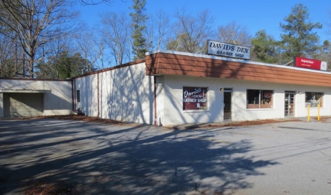
Property Record
5836 Mableton Pky Sw, Mableton, GA 30126
NEARBY LISTINGS FOR SALE OR LEASE
Property Detail
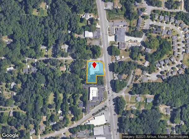
5836 Mableton Pky Sw
18-0039-0-048-0
G W Glore Estates Property
Storebuilding
Cobb
X
Georgia
13067C0212H
0.77 AC
2025
Powder Spring/Austell
2025
Atlanta
031308
Atlanta-Sandy Springs-Roswell, GA
7,904 SF
DEMOGRAPHICS near 5836 Mableton Pky Sw
1 Mile
3 Mile
5 Mile
2024 Total Population
5,850
65,174
148,012
2029 Population
5,967
66,352
150,978
Pop Growth 2024-2029
+ 2.00%
+ 1.81%
+ 2.00%
Average Age
37
37
38
2024 Total Households
2,087
24,145
57,033
HH Growth 2024-2029
+ 1.96%
+ 1.78%
+ 1.97%
Median Household Inc
$67,350
$71,110
$72,481
Avg Household Size
2.70
2.60
2.50
2024 Avg HH Vehicles
2.00
2.00
2.00
Median Home Value
$217,718
$265,820
$285,846
Median Year Built
1968
1985
1987
Nearby Places
Map Layers
Map Styles
 Street
 Aerial
- Restaurants
- Banks
- Shops
- Fitness
- Groceries
PUBLIC TRANSPORTATION
AIRPORT
Hartsfield - Jackson Atlanta International
DRIVE
WALK
Distance
Hartsfield - Jackson Atlanta International
33 min
22.4 mi
Freight Ports
Georgia Ports - Savannah
DRIVE
WALK
Distance
Georgia Ports - Savannah
295 min
259.7 mi
SALE & LEASE HISTORY
LISTING DATE
SALE/LEASE

Nov 11, 2022
For Sale
Apr 30, 2020
For Sale
Nearby Properties
Address
Land Use
TOTAL SIZE
Lot Size
Zoning
Address
Land Use
TOTAL SIZE
Lot Size
Zoning
789,717 SF
68.55 AC
LI
Address
Land Use
TOTAL SIZE
Lot Size
Zoning
307,169 SF
30.13 AC
LI
Address
Land Use
TOTAL SIZE
Lot Size
Zoning
285,933 SF
46.22 AC
R-MF
Address
Land Use
TOTAL SIZE
Lot Size
Zoning
290,784 SF
21.09 AC
RM-12
Address
Land Use
TOTAL SIZE
Lot Size
Zoning
283,396 SF
29.88 AC
RM-12
Address
Land Use
TOTAL SIZE
Lot Size
Zoning
523,551 SF
50.93 AC
LI
Address
Land Use
TOTAL SIZE
Lot Size
Zoning
70.12 AC
Address
Land Use
TOTAL SIZE
Lot Size
Zoning
241,200 SF
18.40 AC
RM-12
Address
Land Use
TOTAL SIZE
Lot Size
Zoning
152,348 SF
12.76 AC
RM-12
Address
Land Use
TOTAL SIZE
Lot Size
Zoning
350,840 SF
22.90 AC
LI
Address
Land Use
TOTAL SIZE
Lot Size
Zoning
151,436 SF
11.42 AC
RM-12
Address
Land Use
TOTAL SIZE
Lot Size
Zoning
353,269 SF
32.80 AC
LI
Address
Land Use
TOTAL SIZE
Lot Size
Zoning
280,670 SF
23 AC
PVC
Address
Land Use
TOTAL SIZE
Lot Size
Zoning
601,350 SF
70.11 AC
LI
Address
Land Use
TOTAL SIZE
Lot Size
Zoning
217,412 SF
18.29 AC
RM-12
Address
Land Use
TOTAL SIZE
Lot Size
Zoning
16.56 AC
LI
Address
Land Use
TOTAL SIZE
Lot Size
Zoning
15.98 AC
LI
Address
Land Use
TOTAL SIZE
Lot Size
Zoning
3.46 AC
RM-12
Address
Land Use
TOTAL SIZE
Lot Size
Zoning
192,776 SF
16.35 AC
RM-12
Address
Land Use
TOTAL SIZE
Lot Size
Zoning
259,325 SF
23.30 AC
LI
Address
Land Use
TOTAL SIZE
Lot Size
Zoning
111,047 SF
14.40 AC
GC
Address
Land Use
TOTAL SIZE
Lot Size
Zoning
111,246 SF
11.28 AC
RM-12
Address
Land Use
TOTAL SIZE
Lot Size
Zoning
121,625 SF
10.40 AC
RM-12
Address
Land Use
TOTAL SIZE
Lot Size
Zoning
109,072 SF
15.23 AC
NRC
Address
Land Use
TOTAL SIZE
Lot Size
Zoning
114,622 SF
11.31 AC
RM-12
Address
Land Use
TOTAL SIZE
Lot Size
Zoning
119,424 SF
11.32 AC
RM-12
Address
Land Use
TOTAL SIZE
Lot Size
Zoning
113,244 SF
7.95 AC
RM-12
Address
Land Use
TOTAL SIZE
Lot Size
Zoning
115,380 SF
10.12 AC
RM-12
Address
Land Use
TOTAL SIZE
Lot Size
Zoning
196,250 SF
11.70 AC
HI
Address
Land Use
TOTAL SIZE
Lot Size
Zoning
89,686 SF
10.60 AC
NRC
The World's #1 Commercial Real Estate Marketplace
Connect with us
© 2025 CoStar Group
The information above has been obtained from sources believed reliable. While we do not doubt its accuracy we have not verified it and make no guarantee, warranty or representation about it. It is your responsibility to independently confirm its accuracy and completeness. Any projections, opinions, assumptions, or estimates used are for example only and do not represent the current or future performance of the property. The value of this transaction to you depends on tax and other factors which should be evaluated by your tax, financial, and legal advisors. You and your advisors should conduct a careful, independent investigation of the property to determine to your satisfaction the suitability of the property for your needs.