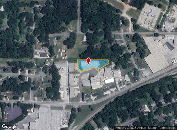
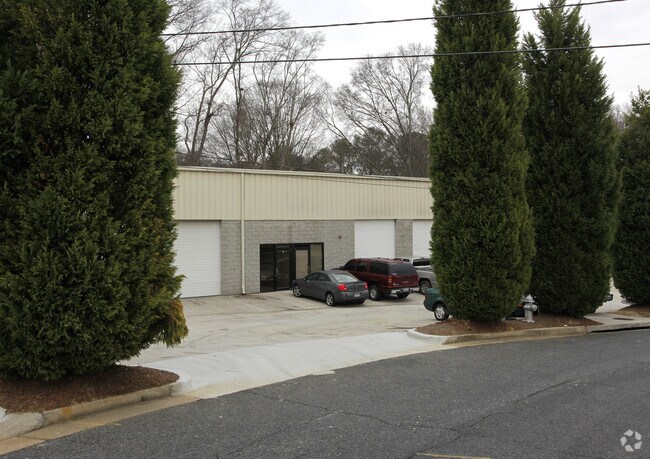
Property Record
5838 Gore Pl, Austell, GA 30106

NEARBY LISTINGS FOR SALE OR LEASE
Property Detail
5838 Gore Pl
18-0093-0-075-0
Burke Family Enterprises Inc
Warehouse
Cobb
X
Georgia
13067C0192H
93
2025
0.81 AC
2025
I-20 W/Douglasville
031415
Atlanta
10,000 SF
Atlanta-Sandy Springs-Roswell, GA
DEMOGRAPHICS near 5838 Gore Pl
1 Mile
3 Mile
5 Mile
2024 Total Population
3,952
45,597
128,005
2029 Population
4,081
46,804
131,394
Pop Growth 2024-2029
+ 3.26%
+ 2.65%
+ 2.65%
Average Age
37
37
38
2024 Total Households
1,470
16,982
46,891
HH Growth 2024-2029
+ 3.27%
+ 2.70%
+ 2.64%
Median Household Inc
$53,304
$60,016
$65,583
Avg Household Size
2.60
2.60
2.70
2024 Avg HH Vehicles
2.00
2.00
2.00
Median Home Value
$171,487
$196,315
$222,693
Median Year Built
1985
1987
1987
Nearby Places
Map Layers
Map Styles
 Street
 Aerial
- Restaurants
- Banks
- Shops
- Fitness
- Groceries
PUBLIC TRANSPORTATION
AIRPORT
Hartsfield - Jackson Atlanta International
DRIVE
WALK
Distance
Hartsfield - Jackson Atlanta International
39 min
25.9 mi
SALE & LEASE HISTORY
LISTING DATE
SALE/LEASE

Sep 24, 2016
For Lease
Jul 23, 2018
For Lease
Nearby Properties
Address
Land Use
TOTAL SIZE
Lot Size
Zoning
Address
Land Use
TOTAL SIZE
Lot Size
Zoning
840,110 SF
53.36 AC
PUD
Address
Land Use
TOTAL SIZE
Lot Size
Zoning
320,073 SF
38.78 AC
R-MF
Address
Land Use
TOTAL SIZE
Lot Size
Zoning
330,754 SF
27.25 AC
R-6
Address
Land Use
TOTAL SIZE
Lot Size
Zoning
318,456 SF
30.91 AC
R-MF
Address
Land Use
TOTAL SIZE
Lot Size
Zoning
222,846 SF
50.74 AC
R-6
Address
Land Use
TOTAL SIZE
Lot Size
Zoning
285,933 SF
46.22 AC
R-MF
Address
Land Use
TOTAL SIZE
Lot Size
Zoning
281,844 SF
38.66 AC
R-MF
Address
Land Use
TOTAL SIZE
Lot Size
Zoning
Address
Land Use
TOTAL SIZE
Lot Size
Zoning
240,612 SF
23.22 AC
R-6
Address
Land Use
TOTAL SIZE
Lot Size
Zoning
380,000 SF
33.97 AC
IL
Address
Land Use
TOTAL SIZE
Lot Size
Zoning
151,436 SF
11.42 AC
RM-12
Address
Land Use
TOTAL SIZE
Lot Size
Zoning
280,670 SF
23 AC
PVC
Address
Land Use
TOTAL SIZE
Lot Size
Zoning
312,093 SF
19.79 AC
PUD
Address
Land Use
TOTAL SIZE
Lot Size
Zoning
312,240 SF
24.58 AC
PUD
Address
Land Use
TOTAL SIZE
Lot Size
Zoning
225,600 SF
50.68 AC
LI-R
Address
Land Use
TOTAL SIZE
Lot Size
Zoning
122,697 SF
13.02 AC
PUD
Address
Land Use
TOTAL SIZE
Lot Size
Zoning
284,307 SF
15.75 AC
LI-R
Address
Land Use
TOTAL SIZE
Lot Size
Zoning
78.60 AC
R20
Address
Land Use
TOTAL SIZE
Lot Size
Zoning
247,000 SF
17.77 AC
PUD
Address
Land Use
TOTAL SIZE
Lot Size
Zoning
261,100 SF
18.52 AC
PUD
Address
Land Use
TOTAL SIZE
Lot Size
Zoning
222,414 SF
11.51 AC
PUD
Address
Land Use
TOTAL SIZE
Lot Size
Zoning
183,750 SF
10.39 AC
PUD
Address
Land Use
TOTAL SIZE
Lot Size
Zoning
182,092 SF
9.70 AC
IL
Address
Land Use
TOTAL SIZE
Lot Size
Zoning
165,592 SF
11.83 AC
IL
Address
Land Use
TOTAL SIZE
Lot Size
Zoning
115,088 SF
18.24 AC
PUD
Address
Land Use
TOTAL SIZE
Lot Size
Zoning
195,000 SF
17.55 AC
PUD
Address
Land Use
TOTAL SIZE
Lot Size
Zoning
224,000 SF
28.83 AC
PUD
Address
Land Use
TOTAL SIZE
Lot Size
Zoning
108,672 SF
7.81 AC
LI-R
Address
Land Use
TOTAL SIZE
Lot Size
Zoning
91,778 SF
7.94 AC
R-6
Address
Land Use
TOTAL SIZE
Lot Size
Zoning
153,774 SF
14.64 AC
PUD
The World's #1 Commercial Real Estate Marketplace
Connect with us
© 2025 CoStar Group
The information above has been obtained from sources believed reliable. While we do not doubt its accuracy we have not verified it and make no guarantee, warranty or representation about it. It is your responsibility to independently confirm its accuracy and completeness. Any projections, opinions, assumptions, or estimates used are for example only and do not represent the current or future performance of the property. The value of this transaction to you depends on tax and other factors which should be evaluated by your tax, financial, and legal advisors. You and your advisors should conduct a careful, independent investigation of the property to determine to your satisfaction the suitability of the property for your needs.