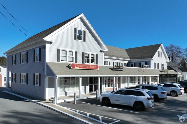
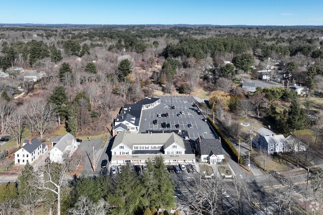
Property Record
584 Main St, Lynnfield, MA 01940
NEARBY LISTINGS FOR SALE OR LEASE
Property Detail
584 Main St
LYNF-000024-000000-002247
Essex
Financialbuilding
Massachusetts
X
2217
25009C0391G
0.09 AC
2025
Lynnfield/Wakefield
2025
Boston
209100
Boston-Cambridge-Newton, MA-NH
2,568 SF
DEMOGRAPHICS near 584 Main St
1 Mile
3 Mile
5 Mile
2024 Total Population
4,220
50,662
154,773
2029 Population
4,215
50,181
153,974
Pop Growth 2024-2029
(0.12%)
(0.95%)
(0.52%)
Average Age
42
43
43
2024 Total Households
1,435
18,768
60,099
HH Growth 2024-2029
(0.35%)
(1.13%)
(0.58%)
Median Household Inc
$171,460
$129,992
$118,716
Avg Household Size
2.90
2.60
2.50
2024 Avg HH Vehicles
2.00
2.00
2.00
Median Home Value
$843,541
$717,343
$680,951
Median Year Built
1963
1964
1968
Nearby Places
Map Layers
Map Styles
 Street
 Aerial
- Restaurants
- Banks
- Shops
- Fitness
- Groceries
PUBLIC TRANSPORTATION
COMMUTER RAIL
Wakefield (Haverhill Line - Massachusetts Bay Transportation Authority Commuter Rail (Purple Line))
DRIVE
WALK
Distance
Wakefield (Haverhill Line - Massachusetts Bay Transportation Authority Commuter Rail (Purple Line))
8 min
3.4 mi
Reading (Haverhill Line - Massachusetts Bay Transportation Authority Commuter Rail (Purple Line))
DRIVE
WALK
Distance
Reading (Haverhill Line - Massachusetts Bay Transportation Authority Commuter Rail (Purple Line))
9 min
3.7 mi
AIRPORT
General Edward Lawrence Logan International
DRIVE
WALK
Distance
General Edward Lawrence Logan International
26 min
15.0 mi
Freight Ports
Port of Boston
DRIVE
WALK
Distance
Port of Boston
29 min
18.0 mi
SALE & LEASE HISTORY
LISTING DATE
SALE/LEASE

Sep 25, 2016
For Lease
Dec 05, 2022
For Lease
Nearby Properties
Address
Land Use
TOTAL SIZE
Lot Size
Zoning
Address
Land Use
TOTAL SIZE
Lot Size
Zoning
213,401 SF
15.16 AC
B
Address
Land Use
TOTAL SIZE
Lot Size
Zoning
215,057 SF
12 AC
RB
Address
Land Use
TOTAL SIZE
Lot Size
Zoning
217,937 SF
8.40 AC
I
Address
Land Use
TOTAL SIZE
Lot Size
Zoning
153,906 SF
4 AC
S15
Address
Land Use
TOTAL SIZE
Lot Size
Zoning
228,797 SF
10.61 AC
MD
Address
Land Use
TOTAL SIZE
Lot Size
Zoning
172,056 SF
I
Address
Land Use
TOTAL SIZE
Lot Size
Zoning
113,502 SF
8.50 AC
LB
Address
Land Use
TOTAL SIZE
Lot Size
Zoning
155,686 SF
2.88 AC
I
Address
Land Use
TOTAL SIZE
Lot Size
Zoning
262,220 SF
11.79 AC
Address
Land Use
TOTAL SIZE
Lot Size
Zoning
254,374 SF
34.70 AC
I
Address
Land Use
TOTAL SIZE
Lot Size
Zoning
167,470 SF
8.50 AC
B
Address
Land Use
TOTAL SIZE
Lot Size
Zoning
156,846 SF
11.79 AC
Address
Land Use
TOTAL SIZE
Lot Size
Zoning
146,088 SF
8.93 AC
IND
Address
Land Use
TOTAL SIZE
Lot Size
Zoning
135,065 SF
1.58 AC
GR
Address
Land Use
TOTAL SIZE
Lot Size
Zoning
110,812 SF
32.87 AC
RA
Address
Land Use
TOTAL SIZE
Lot Size
Zoning
260,027 SF
20 AC
IND
Address
Land Use
TOTAL SIZE
Lot Size
Zoning
76,577 SF
8.56 AC
PUD
Address
Land Use
TOTAL SIZE
Lot Size
Zoning
160,000 SF
14.10 AC
I
Address
Land Use
TOTAL SIZE
Lot Size
Zoning
237,828 SF
12.53 AC
I
Address
Land Use
TOTAL SIZE
Lot Size
Zoning
219,065 SF
23.98 AC
B
Address
Land Use
TOTAL SIZE
Lot Size
Zoning
102,838 SF
8.08 AC
C
Address
Land Use
TOTAL SIZE
Lot Size
Zoning
155,000 SF
9.50 AC
I
Address
Land Use
TOTAL SIZE
Lot Size
Zoning
136,661 SF
27.50 AC
RB
Address
Land Use
TOTAL SIZE
Lot Size
Zoning
74,598 SF
0.61 AC
SR
Address
Land Use
TOTAL SIZE
Lot Size
Zoning
149,500 SF
4.35 AC
I
Address
Land Use
TOTAL SIZE
Lot Size
Zoning
89,742 SF
10.78 AC
RC
Address
Land Use
TOTAL SIZE
Lot Size
Zoning
13.80 AC
BN2
Address
Land Use
TOTAL SIZE
Lot Size
Zoning
96,600 SF
3.33 AC
IND
Address
Land Use
TOTAL SIZE
Lot Size
Zoning
67,108 SF
5.05 AC
IND
Address
Land Use
TOTAL SIZE
Lot Size
Zoning
83,168 SF
4.86 AC
S15
The World's #1 Commercial Real Estate Marketplace
Connect with us
© 2025 CoStar Group
The information above has been obtained from sources believed reliable. While we do not doubt its accuracy we have not verified it and make no guarantee, warranty or representation about it. It is your responsibility to independently confirm its accuracy and completeness. Any projections, opinions, assumptions, or estimates used are for example only and do not represent the current or future performance of the property. The value of this transaction to you depends on tax and other factors which should be evaluated by your tax, financial, and legal advisors. You and your advisors should conduct a careful, independent investigation of the property to determine to your satisfaction the suitability of the property for your needs.