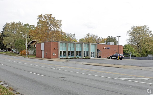
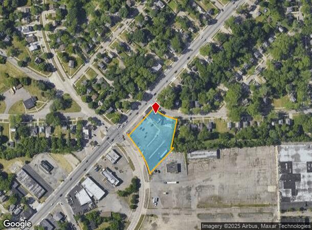
Property Record
584 N Perry St, Pontiac, MI 48342

NEARBY LISTINGS FOR SALE OR LEASE
Property Detail
584 N Perry St
Detroit-Warren-Dearborn, MI
Of Modern Housing Corporation Add
14-21-380-010
T3N, R10E, SEC 21 REPLAT OF LOTS 131, 132, 133, 134, 613 & PART OF LOT 612 OF MODERN HOUSING CORPORATION ADD LOTS 1 TO 10 INCL EXC THAT PART TAKEN FOR WIDING OF PERRY ST, ALSO THAT PART OF LOT 130 LYING NELY OF NELY LINE OF GLENWOOD AVE, ALSO ALL OF
Financialbuilding
Oakland
X
Michigan
26125C0368F
612
2024
1.22 AC
2024
Pontiac
141600
Detroit
4,477 SF
DEMOGRAPHICS near 584 N Perry St
1 Mile
3 Mile
5 Mile
2024 Total Population
11,868
71,727
157,774
2029 Population
11,854
71,665
157,427
Pop Growth 2024-2029
(0.12%)
(0.09%)
(0.22%)
Average Age
36
38
40
2024 Total Households
4,362
28,667
64,913
HH Growth 2024-2029
(0.18%)
(0.18%)
(0.27%)
Median Household Inc
$36,917
$40,699
$60,516
Avg Household Size
2.50
2.40
2.30
2024 Avg HH Vehicles
1.00
2.00
2.00
Median Home Value
$65,985
$95,940
$213,251
Median Year Built
1952
1960
1970
Nearby Places
Map Layers
Map Styles
 Street
 Aerial
- Restaurants
- Banks
- Shops
- Fitness
- Groceries
PUBLIC TRANSPORTATION
COMMUTER RAIL
Pontiac Amtrak Station (Wolverine - Amtrak)
DRIVE
WALK
Distance
Pontiac Amtrak Station (Wolverine - Amtrak)
4 min
1.7 mi
Freight Ports
Port of Toledo
DRIVE
WALK
Distance
Port of Toledo
110 min
90.7 mi
Nearby Properties
Address
Land Use
TOTAL SIZE
Lot Size
Zoning
Address
Land Use
TOTAL SIZE
Lot Size
Zoning
7,879,586 SF
457.68 AC
TR
Address
Land Use
TOTAL SIZE
Lot Size
Zoning
2,734,739 SF
80.39 AC
Address
Land Use
TOTAL SIZE
Lot Size
Zoning
803,597 SF
67 AC
SP
Address
Land Use
TOTAL SIZE
Lot Size
Zoning
238,755 SF
Address
Land Use
TOTAL SIZE
Lot Size
Zoning
526,398 SF
32.99 AC
Address
Land Use
TOTAL SIZE
Lot Size
Zoning
1,771,589 SF
96.73 AC
Address
Land Use
TOTAL SIZE
Lot Size
Zoning
608,251 SF
50.49 AC
II
Address
Land Use
TOTAL SIZE
Lot Size
Zoning
238,755 SF
18.12 AC
Address
Land Use
TOTAL SIZE
Lot Size
Zoning
487,797 SF
34.74 AC
TR
Address
Land Use
TOTAL SIZE
Lot Size
Zoning
278,387 SF
43.37 AC
Address
Land Use
TOTAL SIZE
Lot Size
Zoning
374,400 SF
4.10 AC
Address
Land Use
TOTAL SIZE
Lot Size
Zoning
214,772 SF
Address
Land Use
TOTAL SIZE
Lot Size
Zoning
601,151 SF
Address
Land Use
TOTAL SIZE
Lot Size
Zoning
278,387 SF
Address
Land Use
TOTAL SIZE
Lot Size
Zoning
135,230 SF
Address
Land Use
TOTAL SIZE
Lot Size
Zoning
221,340 SF
26.88 AC
Address
Land Use
TOTAL SIZE
Lot Size
Zoning
172,076 SF
11.18 AC
Address
Land Use
TOTAL SIZE
Lot Size
Zoning
199,125 SF
47.43 AC
Address
Land Use
TOTAL SIZE
Lot Size
Zoning
205,703 SF
21.63 AC
B2
Address
Land Use
TOTAL SIZE
Lot Size
Zoning
107,376 SF
10.18 AC
Address
Land Use
TOTAL SIZE
Lot Size
Zoning
101,320 SF
28.20 AC
Address
Land Use
TOTAL SIZE
Lot Size
Zoning
79,263 SF
22.27 AC
Address
Land Use
TOTAL SIZE
Lot Size
Zoning
903,018 SF
73.92 AC
II
Address
Land Use
TOTAL SIZE
Lot Size
Zoning
87,560 SF
7.94 AC
BI
Address
Land Use
TOTAL SIZE
Lot Size
Zoning
288,124 SF
15.76 AC
Address
Land Use
TOTAL SIZE
Lot Size
Zoning
186,197 SF
12.11 AC
TR
Address
Land Use
TOTAL SIZE
Lot Size
Zoning
128,290 SF
Address
Land Use
TOTAL SIZE
Lot Size
Zoning
1,870,974 SF
61.73 AC
Address
Land Use
TOTAL SIZE
Lot Size
Zoning
152,346 SF
14.07 AC
TR
Address
Land Use
TOTAL SIZE
Lot Size
Zoning
92,524 SF
14.62 AC
TR
The World's #1 Commercial Real Estate Marketplace
Connect with us
© 2025 CoStar Group
The information above has been obtained from sources believed reliable. While we do not doubt its accuracy we have not verified it and make no guarantee, warranty or representation about it. It is your responsibility to independently confirm its accuracy and completeness. Any projections, opinions, assumptions, or estimates used are for example only and do not represent the current or future performance of the property. The value of this transaction to you depends on tax and other factors which should be evaluated by your tax, financial, and legal advisors. You and your advisors should conduct a careful, independent investigation of the property to determine to your satisfaction the suitability of the property for your needs.