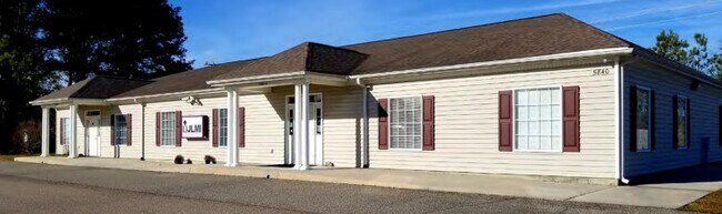
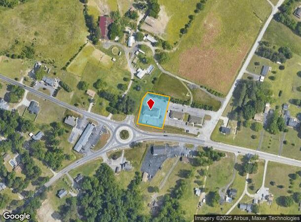
Property Record
5840 Allin Rd, Prince George, VA 23875
NEARBY LISTINGS FOR SALE OR LEASE
Property Detail
5840 Allin Rd
230-26-00-002-0
LT:2 BK: SEC:1; SUB:CEDAR SPRINGS OFFICE PARK; ACRES:0.757;
Officebuilding
Prince George
X
Virginia
51149C0160C
2
2024
0.76 AC
2025
Prince George
850301
Richmond VA
5,000 SF
Richmond, VA
DEMOGRAPHICS near 5840 Allin Rd
1 Mile
3 Mile
5 Mile
2024 Total Population
1,820
17,294
51,058
2029 Population
1,858
17,528
51,055
Pop Growth 2024-2029
+ 2.09%
+ 1.35%
(0.01%)
Average Age
33
35
37
2024 Total Households
538
6,060
17,906
HH Growth 2024-2029
+ 2.23%
+ 1.11%
(0.36%)
Median Household Inc
$72,975
$72,785
$58,678
Avg Household Size
2.80
2.70
2.50
2024 Avg HH Vehicles
2.00
2.00
2.00
Median Home Value
$237,600
$237,419
$168,788
Median Year Built
1997
1995
1980
Nearby Places
Map Layers
Map Styles
 Street
 Aerial
- Restaurants
- Banks
- Shops
- Fitness
- Groceries
PUBLIC TRANSPORTATION
COMMUTER RAIL
Petersburg Amtrak Station (Carolinian - Amtrak, Northeast Regional - Amtrak, Palmetto - Amtrak, Silver Meteor - Amtrak, Silver Star - Amtrak)
DRIVE
WALK
Distance
Petersburg Amtrak Station (Carolinian - Amtrak, Northeast Regional - Amtrak, Palmetto - Amtrak, Silver Meteor - Amtrak, Silver Star - Amtrak)
15 min
9.6 mi
AIRPORT
Richmond International
DRIVE
WALK
Distance
Richmond International
37 min
26.6 mi
Freight Ports
Virginia Port Authority - Richmond
DRIVE
WALK
Distance
Virginia Port Authority - Richmond
35 min
24.0 mi
Nearby Properties
Address
Land Use
TOTAL SIZE
Lot Size
Zoning
Address
Land Use
TOTAL SIZE
Lot Size
Zoning
15,435 SF
13.51 AC
11
Address
Land Use
TOTAL SIZE
Lot Size
Zoning
778,367 SF
155.40 AC
Address
Land Use
TOTAL SIZE
Lot Size
Zoning
157.15 AC
I1
Address
Land Use
TOTAL SIZE
Lot Size
Zoning
138,804 SF
74.15 AC
M2
Address
Land Use
TOTAL SIZE
Lot Size
Zoning
498.93 AC
Address
Land Use
TOTAL SIZE
Lot Size
Zoning
264,335 SF
70 AC
M-2
Address
Land Use
TOTAL SIZE
Lot Size
Zoning
97,040 SF
68.98 AC
RA
Address
Land Use
TOTAL SIZE
Lot Size
Zoning
58,054 SF
14.19 AC
11
Address
Land Use
TOTAL SIZE
Lot Size
Zoning
76,614 SF
16.16 AC
RA
Address
Land Use
TOTAL SIZE
Lot Size
Zoning
186,558 SF
19.06 AC
11
Address
Land Use
TOTAL SIZE
Lot Size
Zoning
252,133 SF
14.59 AC
Address
Land Use
TOTAL SIZE
Lot Size
Zoning
51,463 SF
15.18 AC
I1
Address
Land Use
TOTAL SIZE
Lot Size
Zoning
62,104 SF
20 AC
I1
Address
Land Use
TOTAL SIZE
Lot Size
Zoning
149,472 SF
14.68 AC
R-4
Address
Land Use
TOTAL SIZE
Lot Size
Zoning
278,833 SF
806.30 AC
I1
Address
Land Use
TOTAL SIZE
Lot Size
Zoning
20.47 AC
I1
Address
Land Use
TOTAL SIZE
Lot Size
Zoning
94,052 SF
4.14 AC
11
Address
Land Use
TOTAL SIZE
Lot Size
Zoning
128,816 SF
26.11 AC
I1
Address
Land Use
TOTAL SIZE
Lot Size
Zoning
108.42 AC
Address
Land Use
TOTAL SIZE
Lot Size
Zoning
84 AC
I1
Address
Land Use
TOTAL SIZE
Lot Size
Zoning
25,994 SF
3.75 AC
11
Address
Land Use
TOTAL SIZE
Lot Size
Zoning
143,904 SF
14.44 AC
Address
Land Use
TOTAL SIZE
Lot Size
Zoning
75,410 SF
3.80 AC
11
Address
Land Use
TOTAL SIZE
Lot Size
Zoning
19.50 AC
RA
Address
Land Use
TOTAL SIZE
Lot Size
Zoning
108,900 SF
18.24 AC
I1
Address
Land Use
TOTAL SIZE
Lot Size
Zoning
130,548 SF
13.11 AC
Address
Land Use
TOTAL SIZE
Lot Size
Zoning
16 AC
R-A
Address
Land Use
TOTAL SIZE
Lot Size
Zoning
130,560 SF
20.18 AC
Address
Land Use
TOTAL SIZE
Lot Size
Zoning
1,320 SF
4.83 AC
11
Address
Land Use
TOTAL SIZE
Lot Size
Zoning
159,260 SF
14.62 AC
I1
The World's #1 Commercial Real Estate Marketplace
Connect with us
© 2025 CoStar Group
The information above has been obtained from sources believed reliable. While we do not doubt its accuracy we have not verified it and make no guarantee, warranty or representation about it. It is your responsibility to independently confirm its accuracy and completeness. Any projections, opinions, assumptions, or estimates used are for example only and do not represent the current or future performance of the property. The value of this transaction to you depends on tax and other factors which should be evaluated by your tax, financial, and legal advisors. You and your advisors should conduct a careful, independent investigation of the property to determine to your satisfaction the suitability of the property for your needs.