Property Record
5842 S Taft St, Littleton, CO 80127
NEARBY LISTINGS FOR SALE OR LEASE
-
-
View all Littleton listings for sale on LoopNet.com
Property Detail
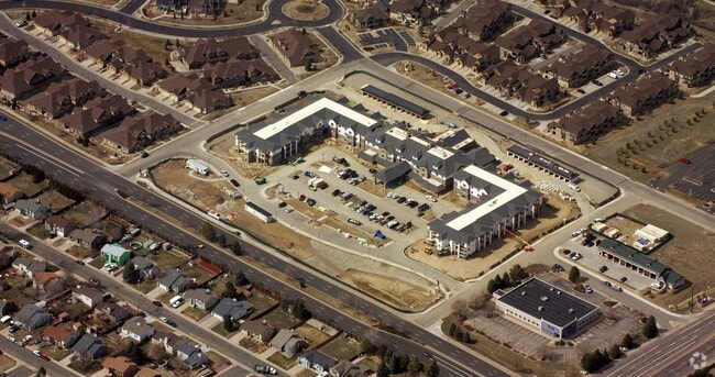
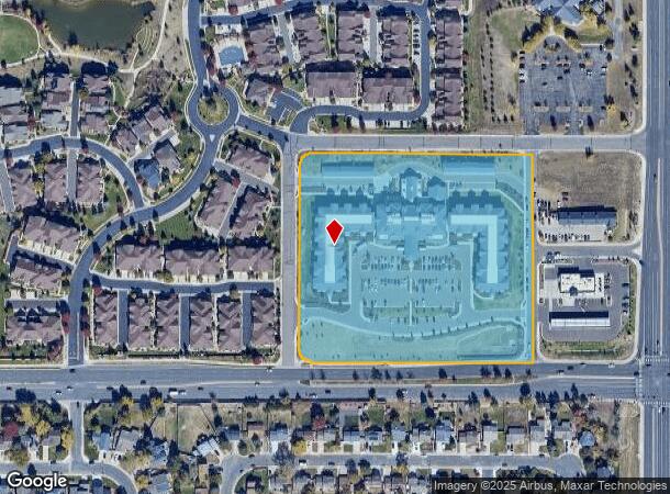
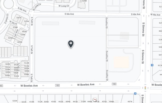
5842 S Taft St
Denver-Aurora-Lakewood, CO
Westgold Meadows Resorts Lifestyle Sub
59-174-12-002
SECTION 17 TOWNSHIP 05 RANGE 69 SUBDIVISIONCD 823560 SUBDIVISIONNAME WESTGOLD MEADOWS RESORTS LIFESTYLE SUB LOT 0001 SIZE: 368062 VALUE: 8.449
Multifamilydwelling
Jefferson
X
Colorado
08059C0382F
1
2023
8.45 AC
2024
Southwest Denver
012043
Denver
177,688 SF
DEMOGRAPHICS near 5842 S Taft St
1 Mile
3 Mile
5 Mile
2024 Total Population
13,981
80,015
171,324
2029 Population
13,725
78,953
169,235
Pop Growth 2024-2029
(1.83%)
(1.33%)
(1.22%)
Average Age
41
42
42
2024 Total Households
5,302
30,929
67,880
HH Growth 2024-2029
(1.85%)
(1.34%)
(1.25%)
Median Household Inc
$114,502
$109,896
$106,177
Avg Household Size
2.60
2.50
2.40
2024 Avg HH Vehicles
2.00
2.00
2.00
Median Home Value
$558,968
$553,361
$584,916
Median Year Built
1992
1987
1985
Nearby Places
Map Layers
Map Styles
 Street
 Aerial
- Restaurants
- Banks
- Shops
- Fitness
- Groceries
Nearby Properties
Address
Land Use
TOTAL SIZE
Lot Size
Zoning
Address
Land Use
TOTAL SIZE
Lot Size
Zoning
272,246 SF
31.76 AC
PD
Address
Land Use
TOTAL SIZE
Lot Size
Zoning
381,135 SF
35.02 AC
Address
Land Use
TOTAL SIZE
Lot Size
Zoning
600,847 SF
32.41 AC
PD
Address
Land Use
TOTAL SIZE
Lot Size
Zoning
600,847 SF
35.87 AC
PD
Address
Land Use
TOTAL SIZE
Lot Size
Zoning
5,075 SF
1,955.14 AC
A2
Address
Land Use
TOTAL SIZE
Lot Size
Zoning
391,595 SF
27.94 AC
Address
Land Use
TOTAL SIZE
Lot Size
Zoning
178,421 SF
12.31 AC
PD
Address
Land Use
TOTAL SIZE
Lot Size
Zoning
293,292 SF
13.78 AC
S-CC
Address
Land Use
TOTAL SIZE
Lot Size
Zoning
304,475 SF
22.32 AC
Address
Land Use
TOTAL SIZE
Lot Size
Zoning
123,843 SF
6.03 AC
Address
Land Use
TOTAL SIZE
Lot Size
Zoning
329,538 SF
14.64 AC
B-4
Address
Land Use
TOTAL SIZE
Lot Size
Zoning
189,672 SF
16.74 AC
PD
Address
Land Use
TOTAL SIZE
Lot Size
Zoning
294,876 SF
12.25 AC
Address
Land Use
TOTAL SIZE
Lot Size
Zoning
150,951 SF
17.90 AC
PD
Address
Land Use
TOTAL SIZE
Lot Size
Zoning
151,602 SF
38.93 AC
Address
Land Use
TOTAL SIZE
Lot Size
Zoning
101,699 SF
10.34 AC
Address
Land Use
TOTAL SIZE
Lot Size
Zoning
183,858 SF
9.30 AC
PUD
Address
Land Use
TOTAL SIZE
Lot Size
Zoning
101,795 SF
12.61 AC
PD
Address
Land Use
TOTAL SIZE
Lot Size
Zoning
105,093 SF
9.32 AC
B-2
Address
Land Use
TOTAL SIZE
Lot Size
Zoning
80,798 SF
12.27 AC
PD
Address
Land Use
TOTAL SIZE
Lot Size
Zoning
175,000 SF
36.25 AC
PD
Address
Land Use
TOTAL SIZE
Lot Size
Zoning
221,123 SF
14.82 AC
PD
Address
Land Use
TOTAL SIZE
Lot Size
Zoning
97,000 SF
9.88 AC
PD
Address
Land Use
TOTAL SIZE
Lot Size
Zoning
138,028 SF
9.80 AC
B-4
Address
Land Use
TOTAL SIZE
Lot Size
Zoning
218,391 SF
9.73 AC
PD
Address
Land Use
TOTAL SIZE
Lot Size
Zoning
70,614 SF
4.78 AC
CDOLI
Address
Land Use
TOTAL SIZE
Lot Size
Zoning
130,822 SF
6.25 AC
PUD
Address
Land Use
TOTAL SIZE
Lot Size
Zoning
82,770 SF
2.35 AC
Address
Land Use
TOTAL SIZE
Lot Size
Zoning
126,624 SF
7.30 AC
R-2-A
Address
Land Use
TOTAL SIZE
Lot Size
Zoning
86,898 SF
8.70 AC
PD
The World's #1 Commercial Real Estate Marketplace
Connect with us
© 2026 CoStar Group
The information above has been obtained from sources believed reliable. While we do not doubt its accuracy we have not verified it and make no guarantee, warranty or representation about it. It is your responsibility to independently confirm its accuracy and completeness. Any projections, opinions, assumptions, or estimates used are for example only and do not represent the current or future performance of the property. The value of this transaction to you depends on tax and other factors which should be evaluated by your tax, financial, and legal advisors. You and your advisors should conduct a careful, independent investigation of the property to determine to your satisfaction the suitability of the property for your needs.