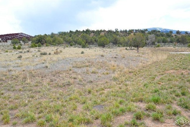
Property Record
585 Gilder Way, Gypsum Area, CO 81637
Property Detail
585 Gilder Way
Edwards, CO
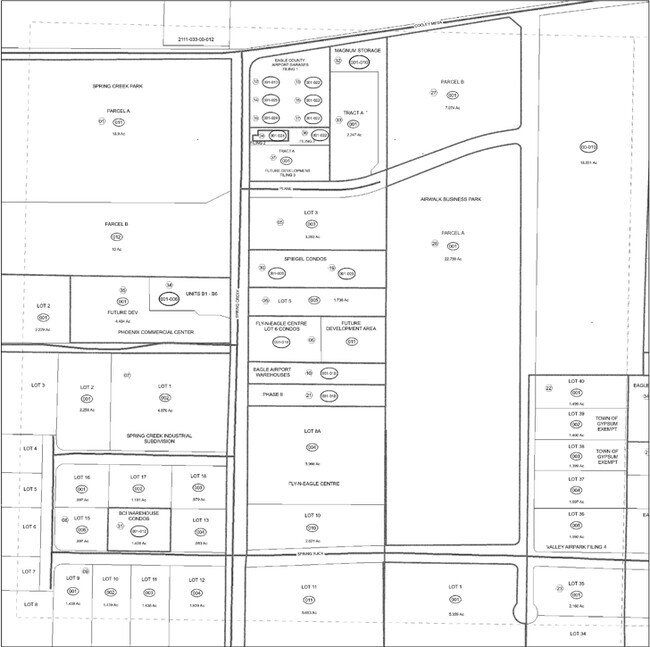
SUBDIVISION: VALLEY AIRPARK FIL 4 LOT: 35
R060069
EAGLE
Warehouse
Colorado
B and X Area of moderate flood hazard, usually the area between the limits of the 100-year and 500-year floods.
35
2024
2.16 AC
2025
Colorado Northwest Area
0002002084
Other Market Areas
17,571 SF
NEARBY LISTINGS FOR SALE OR LEASE
DEMOGRAPHICS near 585 Gilder Way
1 mile
3 mile
5 mile
2025 Total Population
882
6,664
11,602
2030 Population
814
6,293
10,784
Pop Growth 2025-2030
(7.71%)
(5.57%)
(7.05%)
Average Age
35
35
36
2025 Total Households
253
2,031
3,645
HH Growth 2025-2030
(9.09%)
(6.55%)
(8.23%)
Median Household Inc
$75,852
$105,161
$108,839
Avg Household Size
3.10
3.10
3.00
2025 Avg HH Vehicles
2.00
2.00
2.00
Median Home Value
$1,117,614
$677,509
$741,935
Median Year Built
2002
1998
1998
Nearby Places
Map Layers
Map Styles
 Street
 Aerial
Transit
 Traffic
 Biking
Places
Listings with unknown addresses are not visible on the map
- Restaurants
- Banks
- Shops
- Fitness
- Groceries
PUBLIC TRANSPORTATION
AIRPORT
Eagle County Regional
Drive
Walk
Distance
Eagle County Regional
10 min
3.0 mi
SALE & LEASE HISTORY
LISTING DATE
SALE/LEASE

Sep 24, 2016
For Sale
Sep 21, 2020
For Sale
May 17, 2019
For Sale
Nearby Properties
Address
Land Use
TOTAL SIZE
Lot Size
Zoning
Address
Land Use
TOTAL SIZE
Lot Size
Zoning
313,632 SF
4.45 AC
Address
Land Use
TOTAL SIZE
Lot Size
Zoning
163,839 SF
18.42 AC
Address
Land Use
TOTAL SIZE
Lot Size
Zoning
21.40 AC
Address
Land Use
TOTAL SIZE
Lot Size
Zoning
351,535 SF
76.06 AC
Address
Land Use
TOTAL SIZE
Lot Size
Zoning
110,035 SF
20 AC
Address
Land Use
TOTAL SIZE
Lot Size
Zoning
80,005 SF
4.06 AC
Address
Land Use
TOTAL SIZE
Lot Size
Zoning
62,400 SF
5.36 AC
Address
Land Use
TOTAL SIZE
Lot Size
Zoning
35,298 SF
3.88 AC
Address
Land Use
TOTAL SIZE
Lot Size
Zoning
40,050 SF
2.62 AC
Address
Land Use
TOTAL SIZE
Lot Size
Zoning
26,008 SF
10 AC
Address
Land Use
TOTAL SIZE
Lot Size
Zoning
3,120 SF
4.86 AC
Address
Land Use
TOTAL SIZE
Lot Size
Zoning
45,635 SF
2.22 AC
Address
Land Use
TOTAL SIZE
Lot Size
Zoning
55,995 SF
94.35 AC
Address
Land Use
TOTAL SIZE
Lot Size
Zoning
19,588 SF
439.36 AC
Address
Land Use
TOTAL SIZE
Lot Size
Zoning
30,795 SF
1.61 AC
Address
Land Use
TOTAL SIZE
Lot Size
Zoning
63,339 SF
7.22 AC
Address
Land Use
TOTAL SIZE
Lot Size
Zoning
121,154 SF
11.05 AC
Address
Land Use
TOTAL SIZE
Lot Size
Zoning
14,264 SF
10.50 AC
Address
Land Use
TOTAL SIZE
Lot Size
Zoning
22,775 SF
1.47 AC
Address
Land Use
TOTAL SIZE
Lot Size
Zoning
10,000 SF
12.59 AC
Address
Land Use
TOTAL SIZE
Lot Size
Zoning
89,757 SF
3.57 AC
Address
Land Use
TOTAL SIZE
Lot Size
Zoning
23,141 SF
3.54 AC
Address
Land Use
TOTAL SIZE
Lot Size
Zoning
20,080 SF
2.06 AC
Address
Land Use
TOTAL SIZE
Lot Size
Zoning
25,310 SF
14.46 AC
Address
Land Use
TOTAL SIZE
Lot Size
Zoning
4.14 AC
Address
Land Use
TOTAL SIZE
Lot Size
Zoning
35,800 SF
2.92 AC
Address
Land Use
TOTAL SIZE
Lot Size
Zoning
14,400 SF
5.97 AC
Address
Land Use
TOTAL SIZE
Lot Size
Zoning
24,000 SF
1.57 AC
Address
Land Use
TOTAL SIZE
Lot Size
Zoning
24,605 SF
1.99 AC
Address
Land Use
TOTAL SIZE
Lot Size
Zoning
7.44 AC
The World's #1 Commercial Real Estate Marketplace
Connect with us
© 2026 CoStar Group
The information above has been obtained from sources believed reliable. While we do not doubt its accuracy we have not verified it and make no guarantee, warranty or representation about it. It is your responsibility to independently confirm its accuracy and completeness. Any projections, opinions, assumptions, or estimates used are for example only and do not represent the current or future performance of the property. The value of this transaction to you depends on tax and other factors which should be evaluated by your tax, financial, and legal advisors. You and your advisors should conduct a careful, independent investigation of the property to determine to your satisfaction the suitability of the property for your needs.