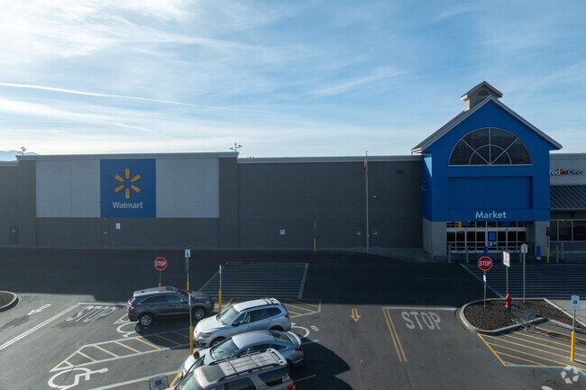
Property Record
585 N State St, Lindon, UT 84042

Save to a Folder
{{folder.Name}}
{{folder.ListingIds.length}} Properties
{{folder.ListingIds.length}} Property
Create a New Folder
Property Detail
585 N State St
Provo-Orem-Lehi, UT
PART LOT 7, PLAT A, LINDON WALMART SUB BETTER DESCRIBED AS; COM N 1086.27 FT & E 322.96 FT FR SW COR. SEC. 28, T5S, R2E, SLB&M.; ALONG A CURVE TO L (CHORD BEARS: N 86 DEG 26 58 E 78.09 FT, RADIUS = 742.64 FT); S 0 DEG 34 49 W 64.62 FT; S 13 DEG 29 30
45-371-0021
Utah
Servicestationmarket
Utah
2025
7
2026
25.89 AC
000603
Utah County
212,912 SF
Salt Lake City
NEARBY LISTINGS FOR SALE OR LEASE
DEMOGRAPHICS near 585 N State St
1 mile
3 mile
5 mile
2025 Total Population
9,051
78,569
187,017
2030 Population
9,872
85,475
205,058
Pop Growth 2025-2030
+ 9.07%
+ 8.79%
+ 9.65%
Average Age
34
34
33
2025 Total Households
2,660
23,797
56,381
HH Growth 2025-2030
+ 9.85%
+ 9.64%
+ 10.46%
Median Household Inc
$93,391
$97,104
$98,161
Avg Household Size
3.40
3.30
3.30
2025 Avg HH Vehicles
2.00
2.00
2.00
Median Home Value
$603,926
$553,050
$569,394
Median Year Built
1994
1997
1997
Nearby Places
Map Layers
Map Styles
 Street
 Aerial
Layers
 Traffic
 Biking
Places
Listings with unknown addresses are not visible on the map
- Restaurants
- Banks
- Shops
- Fitness
- Groceries
PUBLIC TRANSPORTATION
COMMUTER RAIL
Vineyard Station (FrontRunner - Utah Transit Authority (UTA))
Drive
Walk
Distance
Vineyard Station (FrontRunner - Utah Transit Authority (UTA))
9 min
4.5 mi
Orem Central Station (FrontRunner - Utah Transit Authority (UTA))
Drive
Walk
Distance
Orem Central Station (FrontRunner - Utah Transit Authority (UTA))
13 min
6.3 mi
AIRPORT
Provo Municipal
Drive
Walk
Distance
Provo Municipal
21 min
13.1 mi
Freight Ports
Port of Stockton
Drive
Walk
Distance
Port of Stockton
749 min
730.7 mi
Nearby Properties
Address
Land Use
TOTAL SIZE
Lot Size
Zoning
Address
Land Use
TOTAL SIZE
Lot Size
Zoning
587,192 SF
48.27 AC
Address
Land Use
TOTAL SIZE
Lot Size
Zoning
206,178 SF
16.64 AC
Address
Land Use
TOTAL SIZE
Lot Size
Zoning
136.18 AC
Address
Land Use
TOTAL SIZE
Lot Size
Zoning
296,420 SF
19.66 AC
Address
Land Use
TOTAL SIZE
Lot Size
Zoning
536,695 SF
10.39 AC
Address
Land Use
TOTAL SIZE
Lot Size
Zoning
21,510 SF
6.66 AC
Address
Land Use
TOTAL SIZE
Lot Size
Zoning
466,497 SF
9.53 AC
Address
Land Use
TOTAL SIZE
Lot Size
Zoning
7,083 SF
8.99 AC
Address
Land Use
TOTAL SIZE
Lot Size
Zoning
202,624 SF
17.96 AC
Address
Land Use
TOTAL SIZE
Lot Size
Zoning
327,100 SF
14.61 AC
Address
Land Use
TOTAL SIZE
Lot Size
Zoning
230,702 SF
11.85 AC
Address
Land Use
TOTAL SIZE
Lot Size
Zoning
144,310 SF
6.85 AC
Address
Land Use
TOTAL SIZE
Lot Size
Zoning
144,456 SF
5.55 AC
Address
Land Use
TOTAL SIZE
Lot Size
Zoning
414,098 SF
12.78 AC
Address
Land Use
TOTAL SIZE
Lot Size
Zoning
230,114 SF
15.03 AC
Address
Land Use
TOTAL SIZE
Lot Size
Zoning
194,977 SF
8.18 AC
Address
Land Use
TOTAL SIZE
Lot Size
Zoning
308,391 SF
8.96 AC
Address
Land Use
TOTAL SIZE
Lot Size
Zoning
291,932 SF
8.10 AC
Address
Land Use
TOTAL SIZE
Lot Size
Zoning
Address
Land Use
TOTAL SIZE
Lot Size
Zoning
154,800 SF
9.14 AC
Address
Land Use
TOTAL SIZE
Lot Size
Zoning
364,248 SF
22.77 AC
Address
Land Use
TOTAL SIZE
Lot Size
Zoning
171,905 SF
6.62 AC
Address
Land Use
TOTAL SIZE
Lot Size
Zoning
269,768 SF
14.94 AC
Address
Land Use
TOTAL SIZE
Lot Size
Zoning
194,852 SF
10.03 AC
Address
Land Use
TOTAL SIZE
Lot Size
Zoning
213,863 SF
11.71 AC
Address
Land Use
TOTAL SIZE
Lot Size
Zoning
367,151 SF
13.12 AC
Address
Land Use
TOTAL SIZE
Lot Size
Zoning
141,635 SF
10.58 AC
Address
Land Use
TOTAL SIZE
Lot Size
Zoning
37,489 SF
12.59 AC
Address
Land Use
TOTAL SIZE
Lot Size
Zoning
6,568 SF
2.06 AC
The World's #1 Commercial Real Estate Marketplace
Connect with us
© 2026 CoStar Group
The information above has been obtained from sources believed reliable. While we do not doubt its accuracy we have not verified it and make no guarantee, warranty or representation about it. It is your responsibility to independently confirm its accuracy and completeness. Any projections, opinions, assumptions, or estimates used are for example only and do not represent the current or future performance of the property. The value of this transaction to you depends on tax and other factors which should be evaluated by your tax, financial, and legal advisors. You and your advisors should conduct a careful, independent investigation of the property to determine to your satisfaction the suitability of the property for your needs.