Property Record
583 Washington St, Dorchester Center, MA 02124
Current Lease Availabilities
NEARBY LISTINGS FOR SALE OR LEASE
Property Detail
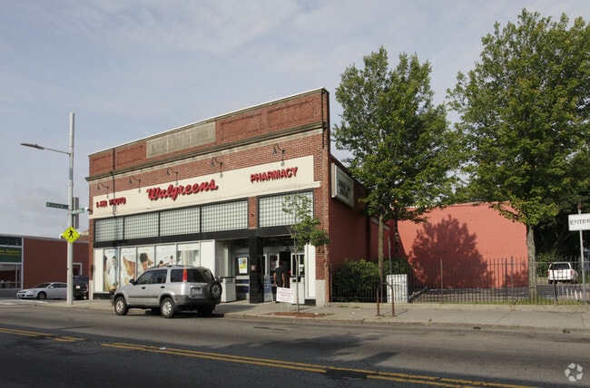
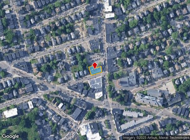
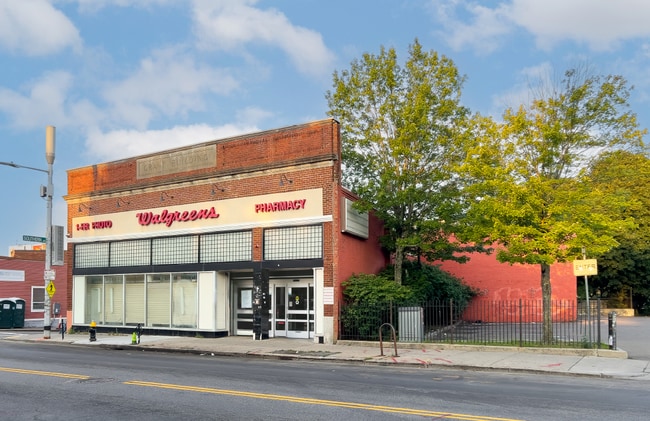
583 Washington St
Storebuilding
Suffolk
X
Massachusetts
25025C0087G
0.17 AC
2025
Roxbury/Dorchester
2025
Boston
092300
Boston-Cambridge-Newton, MA-NH
6,832 SF
DORC-000000-000017-000659
DEMOGRAPHICS near 583 Washington St
1 Mile
3 Mile
5 Mile
2024 Total Population
58,533
276,751
662,391
2029 Population
54,749
262,786
637,541
Pop Growth 2024-2029
(6.46%)
(5.05%)
(3.75%)
Average Age
38
39
38
2024 Total Households
19,896
104,070
268,417
HH Growth 2024-2029
(7.17%)
(5.57%)
(4.02%)
Median Household Inc
$59,105
$70,148
$87,691
Avg Household Size
2.80
2.50
2.20
2024 Avg HH Vehicles
1.00
1.00
1.00
Median Home Value
$608,790
$651,406
$747,305
Median Year Built
1947
1948
1949
Nearby Places
- Restaurants
- Banks
- Shops
- Fitness
- Groceries
PUBLIC TRANSPORTATION
TRANSIT/SUBWAY
Shawmut Station (Red Line - Massachusetts Bay Transportation Authority Subway (The T))
DRIVE
WALK
Distance
Shawmut Station (Red Line - Massachusetts Bay Transportation Authority Subway (The T))
2 min
7 min
0.4 mi
Ashmont Station (Ashmont Mattapan High Speed Line - Massachusetts Bay Transportation Authority Subway (The T), Red Line - Massachusetts Bay Transportation Authority Subway (The T))
DRIVE
WALK
Distance
Ashmont Station (Ashmont Mattapan High Speed Line - Massachusetts Bay Transportation Authority Subway (The T), Red Line - Massachusetts Bay Transportation Authority Subway (The T))
4 min
15 min
0.8 mi
Fields Corner Station (Red Line - Massachusetts Bay Transportation Authority Subway (The T))
DRIVE
WALK
Distance
Fields Corner Station (Red Line - Massachusetts Bay Transportation Authority Subway (The T))
3 min
18 min
0.9 mi
COMMUTER RAIL
Talbot Avenue (Fairmount Line - MBTA, Franklin/Foxboro Line - MBTA)
DRIVE
WALK
Distance
Talbot Avenue (Fairmount Line - MBTA, Franklin/Foxboro Line - MBTA)
1 min
8 min
0.4 mi
Morton Street (Fairmount Line - Massachusetts Bay Transportation Authority Commuter Rail (Purple Line))
DRIVE
WALK
Distance
Morton Street (Fairmount Line - Massachusetts Bay Transportation Authority Commuter Rail (Purple Line))
3 min
1.3 mi
AIRPORT
General Edward Lawrence Logan International
DRIVE
WALK
Distance
General Edward Lawrence Logan International
17 min
8.1 mi
Freight Ports
Port of Boston
DRIVE
WALK
Distance
Port of Boston
14 min
5.8 mi
Nearby Properties
Address
Land Use
TOTAL SIZE
Lot Size
Zoning
Address
Land Use
TOTAL SIZE
Lot Size
Zoning
909,764 SF
25.13 AC
E
Address
Land Use
TOTAL SIZE
Lot Size
Zoning
262,120 SF
0.62 AC
C
Address
Land Use
TOTAL SIZE
Lot Size
Zoning
259,990 SF
2.84 AC
E
Address
Land Use
TOTAL SIZE
Lot Size
Zoning
547,851 SF
8.14 AC
E
Address
Land Use
TOTAL SIZE
Lot Size
Zoning
303,055 SF
2.15 AC
RC
Address
Land Use
TOTAL SIZE
Lot Size
Zoning
522,465 SF
5.34 AC
E
Address
Land Use
TOTAL SIZE
Lot Size
Zoning
251,272 SF
3.77 AC
BUSC
Address
Land Use
TOTAL SIZE
Lot Size
Zoning
254,856 SF
4.05 AC
BUSC
Address
Land Use
TOTAL SIZE
Lot Size
Zoning
146,751 SF
3.39 AC
E
Address
Land Use
TOTAL SIZE
Lot Size
Zoning
428,271 SF
9.65 AC
E
Address
Land Use
TOTAL SIZE
Lot Size
Zoning
25.54 AC
E
Address
Land Use
TOTAL SIZE
Lot Size
Zoning
243,570 SF
0.94 AC
E
Address
Land Use
TOTAL SIZE
Lot Size
Zoning
255,257 SF
2.34 AC
A
Address
Land Use
TOTAL SIZE
Lot Size
Zoning
1,940 SF
58.17 AC
E
Address
Land Use
TOTAL SIZE
Lot Size
Zoning
681,518 SF
34.52 AC
Address
Land Use
TOTAL SIZE
Lot Size
Zoning
240.18 AC
E
Address
Land Use
TOTAL SIZE
Lot Size
Zoning
291,918 SF
1.99 AC
RC
Address
Land Use
TOTAL SIZE
Lot Size
Zoning
332,366 SF
4.86 AC
E
Address
Land Use
TOTAL SIZE
Lot Size
Zoning
728,348 SF
11.71 AC
C
Address
Land Use
TOTAL SIZE
Lot Size
Zoning
219,966 SF
1.37 AC
RC
Address
Land Use
TOTAL SIZE
Lot Size
Zoning
273,051 SF
5.41 AC
E
Address
Land Use
TOTAL SIZE
Lot Size
Zoning
228,215 SF
2.44 AC
RC
Address
Land Use
TOTAL SIZE
Lot Size
Zoning
18,070 SF
119.45 AC
E
Address
Land Use
TOTAL SIZE
Lot Size
Zoning
526,040 SF
27.79 AC
E
Address
Land Use
TOTAL SIZE
Lot Size
Zoning
383,811 SF
5.86 AC
RESB
Address
Land Use
TOTAL SIZE
Lot Size
Zoning
137,800 SF
5.67 AC
E
Address
Land Use
TOTAL SIZE
Lot Size
Zoning
132,321 SF
3.94 AC
RC
Address
Land Use
TOTAL SIZE
Lot Size
Zoning
88.20 AC
E
Address
Land Use
TOTAL SIZE
Lot Size
Zoning
377,249 SF
2.81 AC
RC
Address
Land Use
TOTAL SIZE
Lot Size
Zoning
173,630 SF
4.46 AC
E
The World's #1 Commercial Real Estate Marketplace
Connect with us
© 2025 CoStar Group
The information above has been obtained from sources believed reliable. While we do not doubt its accuracy we have not verified it and make no guarantee, warranty or representation about it. It is your responsibility to independently confirm its accuracy and completeness. Any projections, opinions, assumptions, or estimates used are for example only and do not represent the current or future performance of the property. The value of this transaction to you depends on tax and other factors which should be evaluated by your tax, financial, and legal advisors. You and your advisors should conduct a careful, independent investigation of the property to determine to your satisfaction the suitability of the property for your needs.