No Photo
Property Record
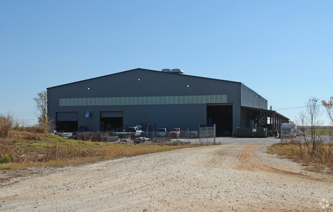
5850 Selma Hwy, Montgomery, AL 36108

NEARBY LISTINGS FOR SALE OR LEASE
-
-
View all Montgomery listings for sale on LoopNet.com
Property Detail
5850 Selma Hwy
13-01-01-0-000-004.001
SEC 1 T15N R16E 6.114 AC N OF SELMA HWY S OF OLD HAYNEVILLE RD 1301010000004001
Publicstorage
Montgomery
X
Alabama
01001C0475E
6.11 AC
2025
South Montgomery
2025
Montgomery
006100
Montgomery, AL
28,924 SF
DEMOGRAPHICS near 5850 Selma Hwy
1 Mile
3 Mile
5 Mile
2024 Total Population
261
2,516
11,368
2029 Population
251
2,435
11,268
Pop Growth 2024-2029
(3.83%)
(3.22%)
(0.88%)
Average Age
43
44
42
2024 Total Households
101
1,015
4,593
HH Growth 2024-2029
(3.96%)
(3.15%)
(0.94%)
Median Household Inc
$33,055
$38,770
$34,010
Avg Household Size
2.60
2.50
2.40
2024 Avg HH Vehicles
2.00
2.00
2.00
Median Home Value
$64,034
$79,074
$83,606
Median Year Built
1971
1974
1975
Nearby Places
Map Layers
Map Styles
 Street
 Aerial
- Restaurants
- Banks
- Shops
- Fitness
- Groceries
PUBLIC TRANSPORTATION
AIRPORT
Montgomery Regional (Dannelly Field)
DRIVE
WALK
Distance
Montgomery Regional (Dannelly Field)
3 min
1.2 mi
Nearby Properties
Address
Land Use
TOTAL SIZE
Lot Size
Zoning
Address
Land Use
TOTAL SIZE
Lot Size
Zoning
263,526 SF
110.10 AC
M-1
Address
Land Use
TOTAL SIZE
Lot Size
Zoning
858,004 SF
61.22 AC
M-1
Address
Land Use
TOTAL SIZE
Lot Size
Zoning
657,684 SF
59 AC
M-1
Address
Land Use
TOTAL SIZE
Lot Size
Zoning
325,084 SF
24.51 AC
M-1
Address
Land Use
TOTAL SIZE
Lot Size
Zoning
129,122 SF
9.60 AC
M-3
Address
Land Use
TOTAL SIZE
Lot Size
Zoning
146,238 SF
8.60 AC
M-1
Address
Land Use
TOTAL SIZE
Lot Size
Zoning
25,763 SF
4.40 AC
M-1
Address
Land Use
TOTAL SIZE
Lot Size
Zoning
48,414 SF
40 AC
Address
Land Use
TOTAL SIZE
Lot Size
Zoning
3,782 SF
165 AC
INST
Address
Land Use
TOTAL SIZE
Lot Size
Zoning
44,559 SF
10 AC
M-3
Address
Land Use
TOTAL SIZE
Lot Size
Zoning
171,222 SF
38.08 AC
M-3
Address
Land Use
TOTAL SIZE
Lot Size
Zoning
29,474 SF
5.05 AC
AGR-1
Address
Land Use
TOTAL SIZE
Lot Size
Zoning
961 SF
8 AC
M-3
Address
Land Use
TOTAL SIZE
Lot Size
Zoning
61,302 SF
11.95 AC
M-1
Address
Land Use
TOTAL SIZE
Lot Size
Zoning
50,760 SF
2.86 AC
M-1
Address
Land Use
TOTAL SIZE
Lot Size
Zoning
632 AC
Address
Land Use
TOTAL SIZE
Lot Size
Zoning
27,009 SF
20 AC
Address
Land Use
TOTAL SIZE
Lot Size
Zoning
8,750 SF
11.25 AC
Address
Land Use
TOTAL SIZE
Lot Size
Zoning
11,936 SF
8.70 AC
R-100
Address
Land Use
TOTAL SIZE
Lot Size
Zoning
92,000 SF
7.70 AC
M-1
Address
Land Use
TOTAL SIZE
Lot Size
Zoning
11,760 SF
163 AC
INST
Address
Land Use
TOTAL SIZE
Lot Size
Zoning
40,514 SF
5 AC
M-1
Address
Land Use
TOTAL SIZE
Lot Size
Zoning
42,440 SF
9.70 AC
M-1
Address
Land Use
TOTAL SIZE
Lot Size
Zoning
31,560 SF
6.80 AC
M-1
Address
Land Use
TOTAL SIZE
Lot Size
Zoning
19,250 SF
6.84 AC
M-1
Address
Land Use
TOTAL SIZE
Lot Size
Zoning
1,764 SF
13.74 AC
M-1
Address
Land Use
TOTAL SIZE
Lot Size
Zoning
160.50 AC
Address
Land Use
TOTAL SIZE
Lot Size
Zoning
19,848 SF
3.50 AC
M-1
Address
Land Use
TOTAL SIZE
Lot Size
Zoning
30,357 SF
16 AC
M-1
The World's #1 Commercial Real Estate Marketplace
Connect with us
© 2025 CoStar Group
The information above has been obtained from sources believed reliable. While we do not doubt its accuracy we have not verified it and make no guarantee, warranty or representation about it. It is your responsibility to independently confirm its accuracy and completeness. Any projections, opinions, assumptions, or estimates used are for example only and do not represent the current or future performance of the property. The value of this transaction to you depends on tax and other factors which should be evaluated by your tax, financial, and legal advisors. You and your advisors should conduct a careful, independent investigation of the property to determine to your satisfaction the suitability of the property for your needs.