Property Record
5851 45Th St, West Palm Beach, FL 33407

NEARBY LISTINGS FOR SALE OR LEASE
Property Detail
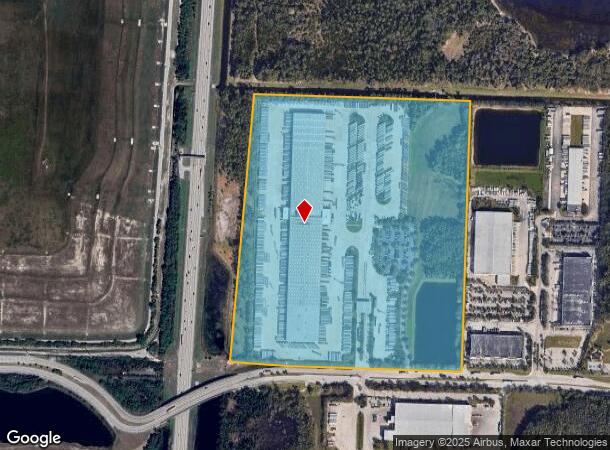
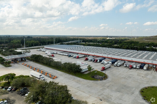
5851 45Th St
74-42-43-02-00-000-3060
Acreage & Unrec
Warehouse
2-43-42~ WLY 1623.22 FT OF NW 1/4 LYG N OF & ADJ TO SR 702 (LESS N 50 FT CNL R/W)
X
Palm Beach
12099C0370F
Florida
2024
67.91 AC
2025
Westroads Area
001002
South Florida
366,446 SF
West Palm Beach-Boca Raton-Delray Beach, FL
DEMOGRAPHICS near 5851 45Th St
1 Mile
3 Mile
5 Mile
2024 Total Population
2,480
52,078
194,952
2029 Population
2,512
54,511
203,202
Pop Growth 2024-2029
+ 1.29%
+ 4.67%
+ 4.23%
Average Age
34
40
41
2024 Total Households
753
20,272
77,980
HH Growth 2024-2029
+ 0.40%
+ 3.95%
+ 3.78%
Median Household Inc
$59,285
$60,666
$54,048
Avg Household Size
3.00
2.40
2.30
2024 Avg HH Vehicles
2.00
2.00
1.00
Median Home Value
$245,600
$235,812
$261,286
Median Year Built
1987
1992
1985
Nearby Places
Map Layers
Map Styles
 Street
 Aerial
- Restaurants
- Banks
- Shops
- Fitness
- Groceries
PUBLIC TRANSPORTATION
COMMUTER RAIL
Mangonia Park (Tri-County Commuter - South Florida Regional Transportation Authority (Tri-Rail))
DRIVE
WALK
Distance
Mangonia Park (Tri-County Commuter - South Florida Regional Transportation Authority (Tri-Rail))
13 min
5.1 mi
West Palm Beach (Tri-County Commuter - South Florida Regional Transportation Authority (Tri-Rail))
DRIVE
WALK
Distance
West Palm Beach (Tri-County Commuter - South Florida Regional Transportation Authority (Tri-Rail))
17 min
8.4 mi
AIRPORT
Palm Beach International
DRIVE
WALK
Distance
Palm Beach International
22 min
11.1 mi
Freight Ports
Port of Palm Beach
DRIVE
WALK
Distance
Port of Palm Beach
17 min
6.9 mi
Nearby Properties
Address
Land Use
TOTAL SIZE
Lot Size
Zoning
Address
Land Use
TOTAL SIZE
Lot Size
Zoning
1,778,741 SF
69.19 AC
CF
Address
Land Use
TOTAL SIZE
Lot Size
Zoning
770,163 SF
571.53 AC
CS
Address
Land Use
TOTAL SIZE
Lot Size
Zoning
650,167 SF
27.64 AC
PCD
Address
Land Use
TOTAL SIZE
Lot Size
Zoning
586,386 SF
19.67 AC
RPD
Address
Land Use
TOTAL SIZE
Lot Size
Zoning
546,847 SF
19.50 AC
RPD
Address
Land Use
TOTAL SIZE
Lot Size
Zoning
411,080 SF
7.59 AC
CPD
Address
Land Use
TOTAL SIZE
Lot Size
Zoning
292,706 SF
30.75 AC
RPD
Address
Land Use
TOTAL SIZE
Lot Size
Zoning
416,171 SF
19.24 AC
R-PUD
Address
Land Use
TOTAL SIZE
Lot Size
Zoning
224,212 SF
141.33 AC
CSPD
Address
Land Use
TOTAL SIZE
Lot Size
Zoning
371,177 SF
17.38 AC
RPD
Address
Land Use
TOTAL SIZE
Lot Size
Zoning
307,554 SF
6.10 AC
CSPD
Address
Land Use
TOTAL SIZE
Lot Size
Zoning
247,028 SF
14.30 AC
RS
Address
Land Use
TOTAL SIZE
Lot Size
Zoning
416,165 SF
42.48 AC
CSPD
Address
Land Use
TOTAL SIZE
Lot Size
Zoning
270,686 SF
56.14 AC
IG
Address
Land Use
TOTAL SIZE
Lot Size
Zoning
299,161 SF
16.85 AC
CSPD
Address
Land Use
TOTAL SIZE
Lot Size
Zoning
323,628 SF
48.15 AC
IG
Address
Land Use
TOTAL SIZE
Lot Size
Zoning
236,554 SF
14.37 AC
IG
Address
Land Use
TOTAL SIZE
Lot Size
Zoning
216,255 SF
25.37 AC
CSPD
Address
Land Use
TOTAL SIZE
Lot Size
Zoning
290,846 SF
20.50 AC
IG
Address
Land Use
TOTAL SIZE
Lot Size
Zoning
259,070 SF
12.95 AC
IL
Address
Land Use
TOTAL SIZE
Lot Size
Zoning
156,102 SF
10.80 AC
RPD
Address
Land Use
TOTAL SIZE
Lot Size
Zoning
171,917 SF
33.79 AC
RPD
Address
Land Use
TOTAL SIZE
Lot Size
Zoning
224,109 SF
6.56 AC
CSPD
Address
Land Use
TOTAL SIZE
Lot Size
Zoning
116,383 SF
7.52 AC
PCD
Address
Land Use
TOTAL SIZE
Lot Size
Zoning
70,660 SF
3.98 AC
CG
Address
Land Use
TOTAL SIZE
Lot Size
Zoning
256,782 SF
20.05 AC
IG
Address
Land Use
TOTAL SIZE
Lot Size
Zoning
194,235 SF
36.73 AC
RS
Address
Land Use
TOTAL SIZE
Lot Size
Zoning
6,132 SF
355.72 AC
PO
Address
Land Use
TOTAL SIZE
Lot Size
Zoning
107,158 SF
14.65 AC
I
The World's #1 Commercial Real Estate Marketplace
Connect with us
© 2025 CoStar Group
The information above has been obtained from sources believed reliable. While we do not doubt its accuracy we have not verified it and make no guarantee, warranty or representation about it. It is your responsibility to independently confirm its accuracy and completeness. Any projections, opinions, assumptions, or estimates used are for example only and do not represent the current or future performance of the property. The value of this transaction to you depends on tax and other factors which should be evaluated by your tax, financial, and legal advisors. You and your advisors should conduct a careful, independent investigation of the property to determine to your satisfaction the suitability of the property for your needs.