Property Record
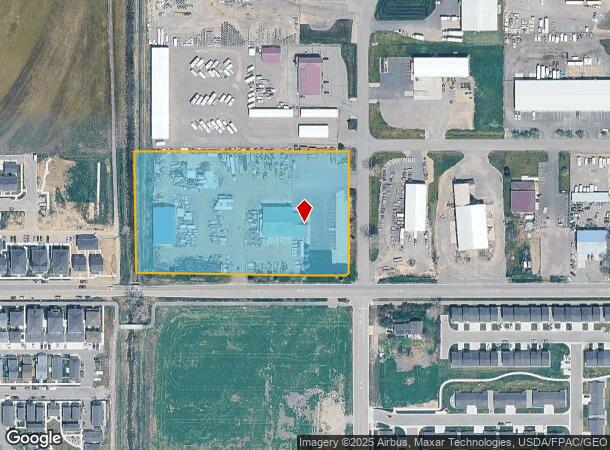
5855 Interstate Ave, Billings, MT 59101
NEARBY LISTINGS FOR SALE OR LEASE
Property Detail
5855 Interstate Ave
Billings, MT
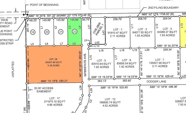
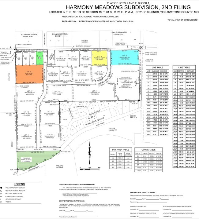
Titan Subd
03-0927-18-4-03-33-0000
Yellowstone
Ruralagriculturalresidence
Montana
X
4.76 AC
30111C1455E
Billings
13,368 SF
Other Market Areas
DEMOGRAPHICS near 5855 Interstate Ave
1 Mile
3 Mile
5 Mile
2024 Total Population
3,644
40,977
94,825
2029 Population
3,996
44,441
102,740
Pop Growth 2024-2029
+ 9.66%
+ 8.45%
+ 8.35%
Average Age
38
40
41
2024 Total Households
1,597
17,771
41,081
HH Growth 2024-2029
+ 9.96%
+ 8.63%
+ 8.54%
Median Household Inc
$59,675
$59,248
$66,306
Avg Household Size
2.30
2.20
2.20
2024 Avg HH Vehicles
2.00
2.00
2.00
Median Home Value
$330,542
$240,825
$291,875
Median Year Built
2008
1978
1975
Nearby Places
Map Layers
Map Styles
 Street
 Aerial
- Restaurants
- Banks
- Shops
- Fitness
- Groceries
PUBLIC TRANSPORTATION
AIRPORT
Billings Logan International
DRIVE
WALK
Distance
Billings Logan International
28 min
10.0 mi
Freight Ports
Port of Everett
DRIVE
WALK
Distance
Port of Everett
881 min
839.0 mi
SALE & LEASE HISTORY
LISTING DATE
SALE/LEASE

Sep 24, 2016
For Sale
Nearby Properties
Address
Land Use
TOTAL SIZE
Lot Size
Zoning
Address
Land Use
TOTAL SIZE
Lot Size
Zoning
136,588 SF
21.01 AC
CI
Address
Land Use
TOTAL SIZE
Lot Size
Zoning
259,684 SF
14.73 AC
Address
Land Use
TOTAL SIZE
Lot Size
Zoning
116,250 SF
9.39 AC
Address
Land Use
TOTAL SIZE
Lot Size
Zoning
537,468 SF
36.83 AC
CC
Address
Land Use
TOTAL SIZE
Lot Size
Zoning
173,807 SF
11.56 AC
CI
Address
Land Use
TOTAL SIZE
Lot Size
Zoning
218,478 SF
18.19 AC
CI
Address
Land Use
TOTAL SIZE
Lot Size
Zoning
109,467 SF
5.97 AC
Address
Land Use
TOTAL SIZE
Lot Size
Zoning
13,216 SF
144.80 AC
A-1
Address
Land Use
TOTAL SIZE
Lot Size
Zoning
172.22 AC
Address
Land Use
TOTAL SIZE
Lot Size
Zoning
177,290 SF
14.59 AC
HC
Address
Land Use
TOTAL SIZE
Lot Size
Zoning
151,056 SF
49.20 AC
A-1
Address
Land Use
TOTAL SIZE
Lot Size
Zoning
1,200 SF
57.17 AC
P
Address
Land Use
TOTAL SIZE
Lot Size
Zoning
409,620 SF
27.42 AC
CI
Address
Land Use
TOTAL SIZE
Lot Size
Zoning
168,560 SF
24.67 AC
Address
Land Use
TOTAL SIZE
Lot Size
Zoning
67.17 AC
Address
Land Use
TOTAL SIZE
Lot Size
Zoning
109,485 SF
8.87 AC
R-96
Address
Land Use
TOTAL SIZE
Lot Size
Zoning
155,084 SF
13.78 AC
P
Address
Land Use
TOTAL SIZE
Lot Size
Zoning
167,744 SF
16.45 AC
CI
Address
Land Use
TOTAL SIZE
Lot Size
Zoning
38,313 SF
3.27 AC
Address
Land Use
TOTAL SIZE
Lot Size
Zoning
86,332 SF
11.18 AC
Address
Land Use
TOTAL SIZE
Lot Size
Zoning
178,736 SF
11.94 AC
HC
Address
Land Use
TOTAL SIZE
Lot Size
Zoning
169,281 SF
11.41 AC
Address
Land Use
TOTAL SIZE
Lot Size
Zoning
5,670 SF
53.89 AC
P
Address
Land Use
TOTAL SIZE
Lot Size
Zoning
22,548 SF
11.39 AC
PUD
Address
Land Use
TOTAL SIZE
Lot Size
Zoning
91,354 SF
5.60 AC
Address
Land Use
TOTAL SIZE
Lot Size
Zoning
22,144 SF
9.64 AC
PUD
Address
Land Use
TOTAL SIZE
Lot Size
Zoning
273,480 SF
9.05 AC
Address
Land Use
TOTAL SIZE
Lot Size
Zoning
136,398 SF
13.05 AC
Address
Land Use
TOTAL SIZE
Lot Size
Zoning
69,342 SF
24.57 AC
P
Address
Land Use
TOTAL SIZE
Lot Size
Zoning
59,920 SF
5.68 AC
The World's #1 Commercial Real Estate Marketplace
Connect with us
© 2025 CoStar Group
The information above has been obtained from sources believed reliable. While we do not doubt its accuracy we have not verified it and make no guarantee, warranty or representation about it. It is your responsibility to independently confirm its accuracy and completeness. Any projections, opinions, assumptions, or estimates used are for example only and do not represent the current or future performance of the property. The value of this transaction to you depends on tax and other factors which should be evaluated by your tax, financial, and legal advisors. You and your advisors should conduct a careful, independent investigation of the property to determine to your satisfaction the suitability of the property for your needs.