Property Record
5855 Washburn Way, Klamath Falls, OR 97603

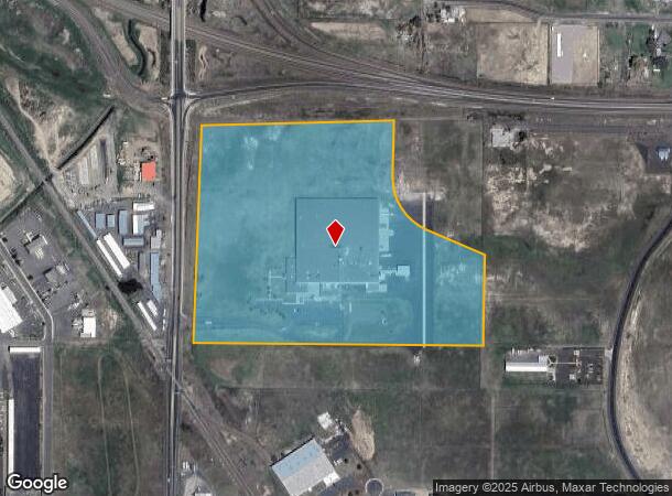
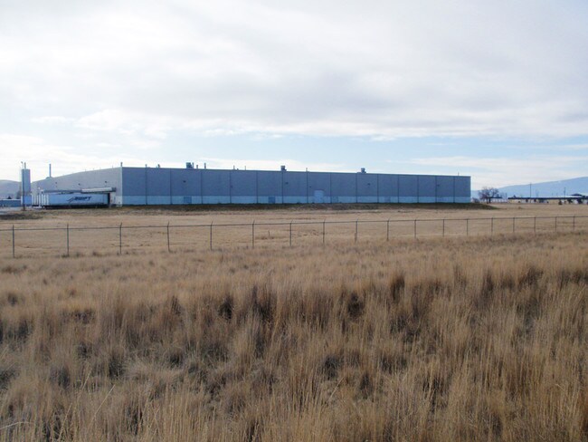
This Property Is For Sale
NEARBY LISTINGS FOR SALE OR LEASE
Property Detail
5855 Washburn Way
R39090150000701000
Lp 52-92 Por Parcel 1
Industrialgeneral
LP 52-92 POR PARCEL 1
X
Klamath
41035C2742C
Oregon
2025
33.10 AC
2025
Oregon East Area
970800
Other Market Areas
200,000 SF
Klamath Falls, OR
DEMOGRAPHICS near 5855 Washburn Way
1 Mile
3 Mile
5 Mile
2024 Total Population
697
19,970
43,925
2029 Population
721
20,636
45,445
Pop Growth 2024-2029
+ 3.44%
+ 3.34%
+ 3.46%
Average Age
41
40
39
2024 Total Households
250
7,922
17,953
HH Growth 2024-2029
+ 3.20%
+ 3.31%
+ 3.45%
Median Household Inc
$45,357
$44,521
$43,657
Avg Household Size
2.50
2.40
2.30
2024 Avg HH Vehicles
2.00
2.00
2.00
Median Home Value
$206,579
$191,110
$210,174
Median Year Built
1960
1972
1971
Nearby Places
Map Layers
Map Styles
 Street
 Aerial
- Restaurants
- Banks
- Shops
- Fitness
- Groceries
PUBLIC TRANSPORTATION
COMMUTER RAIL
Klamath Falls (Coast Starlight - Amtrak)
DRIVE
WALK
Distance
Klamath Falls (Coast Starlight - Amtrak)
13 min
7.0 mi
Freight Ports
Port of Coos Bay, OR
DRIVE
WALK
Distance
Port of Coos Bay, OR
309 min
238.4 mi
Nearby Properties
Address
Land Use
TOTAL SIZE
Lot Size
Zoning
Address
Land Use
TOTAL SIZE
Lot Size
Zoning
8,161 SF
351.27 AC
PF
Address
Land Use
TOTAL SIZE
Lot Size
Zoning
211,167 SF
14.23 AC
GC
Address
Land Use
TOTAL SIZE
Lot Size
Zoning
940 SF
37.21 AC
CR
Address
Land Use
TOTAL SIZE
Lot Size
Zoning
34.73 AC
IH
Address
Land Use
TOTAL SIZE
Lot Size
Zoning
65,600 SF
26.50 AC
PF
Address
Land Use
TOTAL SIZE
Lot Size
Zoning
30,390 SF
12.63 AC
RS
Address
Land Use
TOTAL SIZE
Lot Size
Zoning
22,500 SF
4 AC
LI
Address
Land Use
TOTAL SIZE
Lot Size
Zoning
6.29 AC
L1
Address
Land Use
TOTAL SIZE
Lot Size
Zoning
7.38 AC
I
Address
Land Use
TOTAL SIZE
Lot Size
Zoning
108,500 SF
19.90 AC
IH
Address
Land Use
TOTAL SIZE
Lot Size
Zoning
103.45 AC
PF
Address
Land Use
TOTAL SIZE
Lot Size
Zoning
4,524 SF
0.88 AC
MD,GC
Address
Land Use
TOTAL SIZE
Lot Size
Zoning
1 SF
10.06 AC
IH
Address
Land Use
TOTAL SIZE
Lot Size
Zoning
20,430 SF
2.96 AC
MD,GC
Address
Land Use
TOTAL SIZE
Lot Size
Zoning
66,490 SF
5.68 AC
GC
Address
Land Use
TOTAL SIZE
Lot Size
Zoning
Address
Land Use
TOTAL SIZE
Lot Size
Zoning
50,892 SF
5.67 AC
CG
Address
Land Use
TOTAL SIZE
Lot Size
Zoning
46,191 SF
12.97 AC
RS
Address
Land Use
TOTAL SIZE
Lot Size
Zoning
18.19 AC
IH
Address
Land Use
TOTAL SIZE
Lot Size
Zoning
62,750 SF
8.26 AC
GC,I
Address
Land Use
TOTAL SIZE
Lot Size
Zoning
43,168 SF
7.27 AC
RS
Address
Land Use
TOTAL SIZE
Lot Size
Zoning
0.90 AC
GC,I
Address
Land Use
TOTAL SIZE
Lot Size
Zoning
12.15 AC
GC
Address
Land Use
TOTAL SIZE
Lot Size
Zoning
5,357 SF
5.56 AC
GC
Address
Land Use
TOTAL SIZE
Lot Size
Zoning
24,000 SF
5.81 AC
I
Address
Land Use
TOTAL SIZE
Lot Size
Zoning
32,116 SF
1.43 AC
GC
Address
Land Use
TOTAL SIZE
Lot Size
Zoning
61,056 SF
3.29 AC
GC
Address
Land Use
TOTAL SIZE
Lot Size
Zoning
54,160 SF
4.66 AC
GC
Address
Land Use
TOTAL SIZE
Lot Size
Zoning
1 SF
3.02 AC
CG
Address
Land Use
TOTAL SIZE
Lot Size
Zoning
10,852 SF
9.58 AC
IH
The World's #1 Commercial Real Estate Marketplace
Connect with us
© 2026 CoStar Group
The information above has been obtained from sources believed reliable. While we do not doubt its accuracy we have not verified it and make no guarantee, warranty or representation about it. It is your responsibility to independently confirm its accuracy and completeness. Any projections, opinions, assumptions, or estimates used are for example only and do not represent the current or future performance of the property. The value of this transaction to you depends on tax and other factors which should be evaluated by your tax, financial, and legal advisors. You and your advisors should conduct a careful, independent investigation of the property to determine to your satisfaction the suitability of the property for your needs.