Property Record
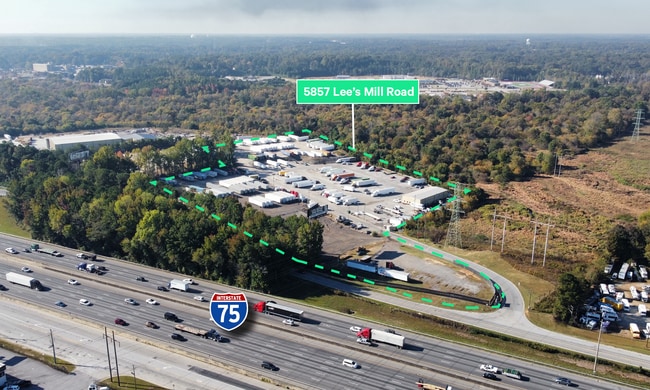
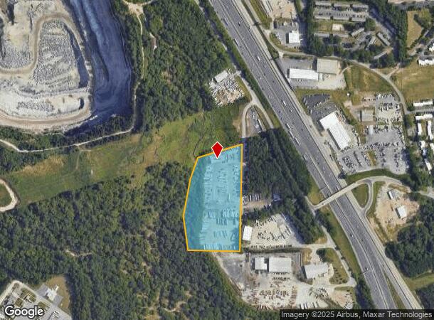
5857 Lees Mill Rd, Forest Park, GA 30297
NEARBY LISTINGS FOR SALE OR LEASE
Property Detail
5857 Lees Mill Rd
13-0108D-00A-009
Clayton
Parkinglot
Georgia
AE
108
13063C0059F
10.11 AC
2025
Airport/North Clayton
2025
Atlanta
040422
Atlanta-Sandy Springs-Roswell, GA
3,927 SF
DEMOGRAPHICS near 5857 Lees Mill Rd
1 Mile
3 Mile
5 Mile
2024 Total Population
8,543
75,015
185,259
2029 Population
8,447
74,670
185,568
Pop Growth 2024-2029
(1.12%)
(0.46%)
+ 0.17%
Average Age
33
35
36
2024 Total Households
3,205
27,763
68,249
HH Growth 2024-2029
(1.28%)
(0.46%)
+ 0.24%
Median Household Inc
$41,200
$41,987
$45,556
Avg Household Size
2.70
2.60
2.60
2024 Avg HH Vehicles
2.00
2.00
2.00
Median Home Value
$114,589
$135,520
$155,102
Median Year Built
1978
1978
1981
Nearby Places
Map Layers
Map Styles
 Street
 Aerial
- Restaurants
- Banks
- Shops
- Fitness
- Groceries
PUBLIC TRANSPORTATION
AIRPORT
Hartsfield - Jackson Atlanta International
DRIVE
WALK
Distance
Hartsfield - Jackson Atlanta International
15 min
5.5 mi
SALE & LEASE HISTORY
LISTING DATE
SALE/LEASE

Oct 21, 2024
For Sale
Oct 13, 2025
For Sale
Nearby Properties
Address
Land Use
TOTAL SIZE
Lot Size
Zoning
Address
Land Use
TOTAL SIZE
Lot Size
Zoning
518,648 SF
31.03 AC
MCD
Address
Land Use
TOTAL SIZE
Lot Size
Zoning
274.75 AC
HI
Address
Land Use
TOTAL SIZE
Lot Size
Zoning
596 SF
57.40 AC
RM
Address
Land Use
TOTAL SIZE
Lot Size
Zoning
370 SF
36.20 AC
RM
Address
Land Use
TOTAL SIZE
Lot Size
Zoning
200,370 SF
23.81 AC
C
Address
Land Use
TOTAL SIZE
Lot Size
Zoning
264 SF
24.92 AC
RM
Address
Land Use
TOTAL SIZE
Lot Size
Zoning
212,048 SF
110.06 AC
HI
Address
Land Use
TOTAL SIZE
Lot Size
Zoning
387 SF
32.53 AC
RM
Address
Land Use
TOTAL SIZE
Lot Size
Zoning
96,028 SF
21.02 AC
I
Address
Land Use
TOTAL SIZE
Lot Size
Zoning
252 SF
27.14 AC
RM
Address
Land Use
TOTAL SIZE
Lot Size
Zoning
308,683 SF
41.30 AC
C
Address
Land Use
TOTAL SIZE
Lot Size
Zoning
216 SF
24.45 AC
RM
Address
Land Use
TOTAL SIZE
Lot Size
Zoning
200 SF
20.71 AC
RM
Address
Land Use
TOTAL SIZE
Lot Size
Zoning
190 SF
21.66 AC
RM
Address
Land Use
TOTAL SIZE
Lot Size
Zoning
298,674 SF
14.35 AC
I
Address
Land Use
TOTAL SIZE
Lot Size
Zoning
410 SF
35 AC
RM
Address
Land Use
TOTAL SIZE
Lot Size
Zoning
167,008 SF
36.21 AC
HI
Address
Land Use
TOTAL SIZE
Lot Size
Zoning
240 SF
28.43 AC
RM
Address
Land Use
TOTAL SIZE
Lot Size
Zoning
422,480 SF
19.42 AC
HI
Address
Land Use
TOTAL SIZE
Lot Size
Zoning
240 SF
27 AC
HI
Address
Land Use
TOTAL SIZE
Lot Size
Zoning
296 SF
27.93 AC
RM
Address
Land Use
TOTAL SIZE
Lot Size
Zoning
411,859 SF
15.80 AC
I
Address
Land Use
TOTAL SIZE
Lot Size
Zoning
198 SF
32.10 AC
RM
Address
Land Use
TOTAL SIZE
Lot Size
Zoning
208 SF
19.26 AC
RM
Address
Land Use
TOTAL SIZE
Lot Size
Zoning
203,067 SF
18 AC
C
Address
Land Use
TOTAL SIZE
Lot Size
Zoning
180,300 SF
12.77 AC
WH
Address
Land Use
TOTAL SIZE
Lot Size
Zoning
522,376 SF
24.36 AC
I
Address
Land Use
TOTAL SIZE
Lot Size
Zoning
280,538 SF
14.28 AC
I
Address
Land Use
TOTAL SIZE
Lot Size
Zoning
108,738 SF
28.31 AC
C
Address
Land Use
TOTAL SIZE
Lot Size
Zoning
230 SF
21.20 AC
RM
The World's #1 Commercial Real Estate Marketplace
Connect with us
© 2025 CoStar Group
The information above has been obtained from sources believed reliable. While we do not doubt its accuracy we have not verified it and make no guarantee, warranty or representation about it. It is your responsibility to independently confirm its accuracy and completeness. Any projections, opinions, assumptions, or estimates used are for example only and do not represent the current or future performance of the property. The value of this transaction to you depends on tax and other factors which should be evaluated by your tax, financial, and legal advisors. You and your advisors should conduct a careful, independent investigation of the property to determine to your satisfaction the suitability of the property for your needs.