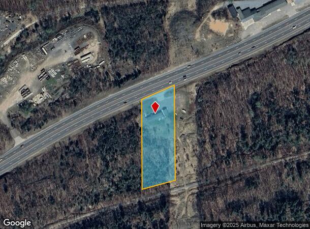
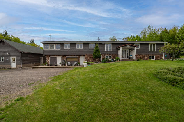
Property Record
586 Us Highway 41 E, Negaunee, MI 49866

NEARBY LISTINGS FOR SALE OR LEASE
Property Detail
586 Us Highway 41 E
52-10-124-050-10
SEC 24 T48N R26W THE E 175' OF NE 1/4 OF SE 1/4 LYING S OF US 41 & N OF SOO LINE R/W.
Commercialnec
Marquette
X
Michigan
26103C0675E
1.70 AC
2024
Upper Peninsula
2025
Other Market Areas
001600
Marquette, MI
1,515 SF
DEMOGRAPHICS near 586 Us Highway 41 E
1 Mile
3 Mile
5 Mile
2024 Total Population
269
5,436
26,218
2029 Population
275
5,519
26,529
Pop Growth 2024-2029
+ 2.23%
+ 1.53%
+ 1.19%
Average Age
43
42
39
2024 Total Households
113
2,385
10,685
HH Growth 2024-2029
+ 2.65%
+ 1.64%
+ 1.22%
Median Household Inc
$89,999
$70,227
$52,387
Avg Household Size
2.40
2.20
2.10
2024 Avg HH Vehicles
2.00
2.00
2.00
Median Home Value
$299,999
$250,304
$231,651
Median Year Built
1989
1986
1972
Nearby Places
Map Layers
Map Styles
 Street
 Aerial
- Restaurants
- Banks
- Shops
- Fitness
- Groceries
PUBLIC TRANSPORTATION
AIRPORT
Marquette/Sawyer Regional
DRIVE
WALK
Distance
Marquette/Sawyer Regional
31 min
19.2 mi
SALE & LEASE HISTORY
LISTING DATE
SALE/LEASE

Sep 23, 2016
For Sale
Oct 23, 2023
For Sale
Nearby Properties
Address
Land Use
TOTAL SIZE
Lot Size
Zoning
Address
Land Use
TOTAL SIZE
Lot Size
Zoning
104,333 SF
8.14 AC
RC
Address
Land Use
TOTAL SIZE
Lot Size
Zoning
195,283 SF
10.25 AC
DD
Address
Land Use
TOTAL SIZE
Lot Size
Zoning
0.29 AC
R-3-L/R
Address
Land Use
TOTAL SIZE
Lot Size
Zoning
206,601 SF
21.83 AC
GB
Address
Land Use
TOTAL SIZE
Lot Size
Zoning
79,558 SF
17.85 AC
RC
Address
Land Use
TOTAL SIZE
Lot Size
Zoning
156,460 SF
14.25 AC
GB
Address
Land Use
TOTAL SIZE
Lot Size
Zoning
220,560 SF
22.20 AC
GB
Address
Land Use
TOTAL SIZE
Lot Size
Zoning
152.60 AC
RP
Address
Land Use
TOTAL SIZE
Lot Size
Zoning
49,463 SF
5.16 AC
PUD
Address
Land Use
TOTAL SIZE
Lot Size
Zoning
7.89 AC
DD
Address
Land Use
TOTAL SIZE
Lot Size
Zoning
125,381 SF
13.11 AC
GB
Address
Land Use
TOTAL SIZE
Lot Size
Zoning
36,600 SF
6.06 AC
GB
Address
Land Use
TOTAL SIZE
Lot Size
Zoning
95,476 SF
7.29 AC
GB
Address
Land Use
TOTAL SIZE
Lot Size
Zoning
45,426 SF
1.86 AC
GB
Address
Land Use
TOTAL SIZE
Lot Size
Zoning
80,156 SF
7.70 AC
DD
Address
Land Use
TOTAL SIZE
Lot Size
Zoning
22,385 SF
17.82 AC
GB
Address
Land Use
TOTAL SIZE
Lot Size
Zoning
Address
Land Use
TOTAL SIZE
Lot Size
Zoning
37.63 AC
DD
Address
Land Use
TOTAL SIZE
Lot Size
Zoning
112,044 SF
5.90 AC
GB
Address
Land Use
TOTAL SIZE
Lot Size
Zoning
31,667 SF
6.70 AC
DD
Address
Land Use
TOTAL SIZE
Lot Size
Zoning
51,400 SF
3.08 AC
GB
Address
Land Use
TOTAL SIZE
Lot Size
Zoning
54,048 SF
3.47 AC
GB
Address
Land Use
TOTAL SIZE
Lot Size
Zoning
80,000 SF
4 AC
GB
Address
Land Use
TOTAL SIZE
Lot Size
Zoning
25,920 SF
9.84 AC
DD
Address
Land Use
TOTAL SIZE
Lot Size
Zoning
46,336 SF
6.19 AC
DD
Address
Land Use
TOTAL SIZE
Lot Size
Zoning
24,184 SF
7.15 AC
DD
Address
Land Use
TOTAL SIZE
Lot Size
Zoning
12,000 SF
7.39 AC
UR
Address
Land Use
TOTAL SIZE
Lot Size
Zoning
42,666 SF
3.61 AC
UR
Address
Land Use
TOTAL SIZE
Lot Size
Zoning
30,390 SF
2.68 AC
GB
Address
Land Use
TOTAL SIZE
Lot Size
Zoning
25,368 SF
5.99 AC
DD
The World's #1 Commercial Real Estate Marketplace
Connect with us
© 2025 CoStar Group
The information above has been obtained from sources believed reliable. While we do not doubt its accuracy we have not verified it and make no guarantee, warranty or representation about it. It is your responsibility to independently confirm its accuracy and completeness. Any projections, opinions, assumptions, or estimates used are for example only and do not represent the current or future performance of the property. The value of this transaction to you depends on tax and other factors which should be evaluated by your tax, financial, and legal advisors. You and your advisors should conduct a careful, independent investigation of the property to determine to your satisfaction the suitability of the property for your needs.