Property Record
5861 Route 202, Lahaska, PA

Property Detail
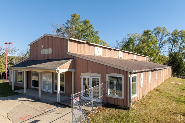
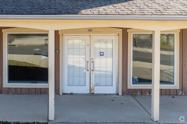
5861 Route 202
06-016-015
14.153A S S US202 439 W STREET RD 494 ON US202
Regionalshoppingcenterormallwithanchorstore
BUCKS
VC2
Pennsylvania
B and X Area of moderate flood hazard, usually the area between the limits of the 100-year and 500-year floods.
14.15 AC
2024
Lower Bucks County
2025
Philadelphia
104506
Philadelphia-Camden-Wilmington, PA-NJ-DE-MD
102,144 SF
NEARBY LISTINGS FOR SALE OR LEASE
DEMOGRAPHICS near 5861 Route 202
1 mile
3 mile
5 mile
2025 Total Population
1,037
10,014
39,085
2030 Population
1,025
9,898
38,853
Pop Growth 2025-2030
(1.16%)
(1.16%)
(0.59%)
Average Age
48
47
46
2025 Total Households
413
3,858
15,155
HH Growth 2025-2030
(1.21%)
(1.30%)
(0.57%)
Median Household Inc
$171,126
$172,306
$166,051
Avg Household Size
2.50
2.60
2.50
2025 Avg HH Vehicles
2.00
2.00
2.00
Median Home Value
$835,804
$823,044
$755,504
Median Year Built
1991
1988
1984
Nearby Places
Map Layers
Map Styles
 Street
 Aerial
Transit
 Traffic
 Biking
Places
Listings with unknown addresses are not visible on the map
- Restaurants
- Banks
- Shops
- Fitness
- Groceries
PUBLIC TRANSPORTATION
COMMUTER RAIL
Doylestown (R5 - Southeastern Pennsylvania Transportation Authority Regional Rail (SEPTA Regional Rail))
Drive
Walk
Distance
Doylestown (R5 - Southeastern Pennsylvania Transportation Authority Regional Rail (SEPTA Regional Rail))
13 min
6.4 mi
Delaware Valley College (R5 - Southeastern Pennsylvania Transportation Authority Regional Rail (SEPTA Regional Rail))
Drive
Walk
Distance
Delaware Valley College (R5 - Southeastern Pennsylvania Transportation Authority Regional Rail (SEPTA Regional Rail))
16 min
9.1 mi
AIRPORT
Trenton Mercer
Drive
Walk
Distance
Trenton Mercer
28 min
16.2 mi
Freight Ports
Port of Philadelphia
Drive
Walk
Distance
Port of Philadelphia
53 min
30.3 mi
SALE & LEASE HISTORY
LISTING DATE
SALE/LEASE

Sep 25, 2016
For Lease
Nearby Properties
Address
Land Use
TOTAL SIZE
Lot Size
Zoning
Address
Land Use
TOTAL SIZE
Lot Size
Zoning
68,430 SF
3.54 AC
HC
Address
Land Use
TOTAL SIZE
Lot Size
Zoning
25,043 SF
0.36 AC
LC
Address
Land Use
TOTAL SIZE
Lot Size
Zoning
45,479 SF
6.79 AC
LC
Address
Land Use
TOTAL SIZE
Lot Size
Zoning
4.41 AC
VC2
Address
Land Use
TOTAL SIZE
Lot Size
Zoning
12,212 SF
5.63 AC
VC2
Address
Land Use
TOTAL SIZE
Lot Size
Zoning
82,623 SF
15.36 AC
VC2
Address
Land Use
TOTAL SIZE
Lot Size
Zoning
10,518 SF
5.39 AC
HC
Address
Land Use
TOTAL SIZE
Lot Size
Zoning
20,962 SF
7.70 AC
HC
Address
Land Use
TOTAL SIZE
Lot Size
Zoning
24,518 SF
2.15 AC
RC
Address
Land Use
TOTAL SIZE
Lot Size
Zoning
10,248 SF
51.21 AC
R2
Address
Land Use
TOTAL SIZE
Lot Size
Zoning
24,655 SF
2.21 AC
VC2
Address
Land Use
TOTAL SIZE
Lot Size
Zoning
10,140 SF
0.39 AC
HC
Address
Land Use
TOTAL SIZE
Lot Size
Zoning
8,714 SF
4.63 AC
R2
Address
Land Use
TOTAL SIZE
Lot Size
Zoning
6,266 SF
1.62 AC
LC
Address
Land Use
TOTAL SIZE
Lot Size
Zoning
3,726 SF
3.11 AC
HC
Address
Land Use
TOTAL SIZE
Lot Size
Zoning
11,128 SF
8.04 AC
AG
Address
Land Use
TOTAL SIZE
Lot Size
Zoning
11,741 SF
0.99 AC
LC
Address
Land Use
TOTAL SIZE
Lot Size
Zoning
10,500 SF
0.38 AC
HC
Address
Land Use
TOTAL SIZE
Lot Size
Zoning
10,997 SF
10.07 AC
VC1
Address
Land Use
TOTAL SIZE
Lot Size
Zoning
4,150 SF
1.98 AC
R1
Address
Land Use
TOTAL SIZE
Lot Size
Zoning
15,078 SF
5.15 AC
R2
Address
Land Use
TOTAL SIZE
Lot Size
Zoning
5,431 SF
0.95 AC
HC
Address
Land Use
TOTAL SIZE
Lot Size
Zoning
3,825 SF
2.34 AC
LC
Address
Land Use
TOTAL SIZE
Lot Size
Zoning
5,586 SF
2.20 AC
HC
Address
Land Use
TOTAL SIZE
Lot Size
Zoning
5,560 SF
2.26 AC
AG
Address
Land Use
TOTAL SIZE
Lot Size
Zoning
3,276 SF
1.07 AC
VC2
Address
Land Use
TOTAL SIZE
Lot Size
Zoning
4,702 SF
0.31 AC
VC2
Address
Land Use
TOTAL SIZE
Lot Size
Zoning
2,814 SF
1.14 AC
VC2
Address
Land Use
TOTAL SIZE
Lot Size
Zoning
3,408 SF
2.58 AC
R2
The World's #1 Commercial Real Estate Marketplace
Connect with us
© 2026 CoStar Group
The information above has been obtained from sources believed reliable. While we do not doubt its accuracy we have not verified it and make no guarantee, warranty or representation about it. It is your responsibility to independently confirm its accuracy and completeness. Any projections, opinions, assumptions, or estimates used are for example only and do not represent the current or future performance of the property. The value of this transaction to you depends on tax and other factors which should be evaluated by your tax, financial, and legal advisors. You and your advisors should conduct a careful, independent investigation of the property to determine to your satisfaction the suitability of the property for your needs.