Property Record
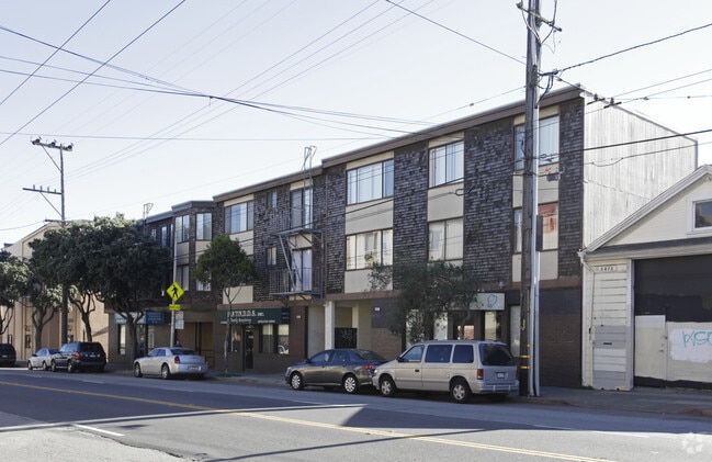
5867 Mission St, San Francisco, CA 94112


This Property Is For Sale
NEARBY LISTINGS FOR SALE OR LEASE
Property Detail
5867 Mission St
San Francisco
5865 5867 Mission Street A Condominium
San Francisco-Redwood City-South San Francisco, CA
San Francisco
6472-055
California
Condominium
0.14 AC
895 SF
Southern City
DEMOGRAPHICS near 5867 Mission St
1 Mile
3 Mile
5 Mile
2024 Total Population
53,532
275,344
677,383
2029 Population
48,591
253,585
627,865
Pop Growth 2024-2029
(9.23%)
(7.90%)
(7.31%)
Average Age
43
43
42
2024 Total Households
15,030
89,256
245,879
HH Growth 2024-2029
(9.61%)
(8.22%)
(7.68%)
Median Household Inc
$107,277
$117,393
$126,460
Avg Household Size
3.30
2.90
2.60
2024 Avg HH Vehicles
2.00
2.00
1.00
Median Home Value
$1,005,266
$1,075,332
$1,082,882
Median Year Built
1950
1953
1951
Nearby Places
Map Layers
Map Styles
 Street
 Aerial
- Restaurants
- Banks
- Shops
- Fitness
- Groceries
PUBLIC TRANSPORTATION
TRANSIT/SUBWAY
Broad And Plymouth (M Ocean View - San Francisco Municipal Railway (MUNI Metro), OCEAN VIEW - San Francisco Municipal Railway (MUNI Metro))
DRIVE
WALK
Distance
Broad And Plymouth (M Ocean View - San Francisco Municipal Railway (MUNI Metro), OCEAN VIEW - San Francisco Municipal Railway (MUNI Metro))
2 min
9 min
0.5 mi
San Jose Ave & Farallones St (M Ocean View - San Francisco Municipal Railway (MUNI Metro))
DRIVE
WALK
Distance
San Jose Ave & Farallones St (M Ocean View - San Francisco Municipal Railway (MUNI Metro))
2 min
11 min
0.6 mi
Broad And Capitol (M Ocean View - San Francisco Municipal Railway (MUNI Metro))
DRIVE
WALK
Distance
Broad And Capitol (M Ocean View - San Francisco Municipal Railway (MUNI Metro))
2 min
12 min
0.6 mi
Broad St & Capitol Ave (OCEAN VIEW - San Francisco Municipal Transportation Agency)
DRIVE
WALK
Distance
Broad St & Capitol Ave (OCEAN VIEW - San Francisco Municipal Transportation Agency)
2 min
12 min
0.6 mi
San Jose And Lakeview (M Ocean View - San Francisco Municipal Railway (MUNI Metro), OCEAN VIEW - San Francisco Municipal Railway (MUNI Metro))
DRIVE
WALK
Distance
San Jose And Lakeview (M Ocean View - San Francisco Municipal Railway (MUNI Metro), OCEAN VIEW - San Francisco Municipal Railway (MUNI Metro))
3 min
15 min
0.8 mi
COMMUTER RAIL
Bayshore Caltrain Station (Local - Caltrain (Caltrain), Local Weekday - Caltrain (Caltrain), Local Weekend - Caltrain (Caltrain))
DRIVE
WALK
Distance
Bayshore Caltrain Station (Local - Caltrain (Caltrain), Local Weekday - Caltrain (Caltrain), Local Weekend - Caltrain (Caltrain))
10 min
3.6 mi
South San Francisco (Caltrain - Caltrain (Caltrain), Express - Caltrain (Caltrain), Limited - Caltrain (Caltrain), Local Weekday - Caltrain (Caltrain), Local Weekend - Caltrain (Caltrain))
DRIVE
WALK
Distance
South San Francisco (Caltrain - Caltrain (Caltrain), Express - Caltrain (Caltrain), Limited - Caltrain (Caltrain), Local Weekday - Caltrain (Caltrain), Local Weekend - Caltrain (Caltrain))
15 min
7.3 mi
AIRPORT
San Francisco International
DRIVE
WALK
Distance
San Francisco International
19 min
11.6 mi
Metro Oakland International
DRIVE
WALK
Distance
Metro Oakland International
39 min
26.6 mi
Freight Ports
Port of San Francisco
DRIVE
WALK
Distance
Port of San Francisco
15 min
9.2 mi
Nearby Properties
Address
Land Use
TOTAL SIZE
Lot Size
Zoning
Address
Land Use
TOTAL SIZE
Lot Size
Zoning
411,904 SF
21.74 AC
C2
Address
Land Use
TOTAL SIZE
Lot Size
Zoning
53.85 AC
Address
Land Use
TOTAL SIZE
Lot Size
Zoning
346,710 SF
7.45 AC
RH2
Address
Land Use
TOTAL SIZE
Lot Size
Zoning
312,191 SF
2.74 AC
Address
Land Use
TOTAL SIZE
Lot Size
Zoning
42.95 AC
Address
Land Use
TOTAL SIZE
Lot Size
Zoning
447,674 SF
21.51 AC
Address
Land Use
TOTAL SIZE
Lot Size
Zoning
183,284 SF
6.85 AC
PD0000
Address
Land Use
TOTAL SIZE
Lot Size
Zoning
2.03 AC
C2
Address
Land Use
TOTAL SIZE
Lot Size
Zoning
88,900 SF
5.37 AC
NCS
Address
Land Use
TOTAL SIZE
Lot Size
Zoning
11.31 AC
RM2
Address
Land Use
TOTAL SIZE
Lot Size
Zoning
160,983 SF
1.84 AC
NC2
Address
Land Use
TOTAL SIZE
Lot Size
Zoning
279,560 SF
13.24 AC
M10000
Address
Land Use
TOTAL SIZE
Lot Size
Zoning
10.62 AC
Address
Land Use
TOTAL SIZE
Lot Size
Zoning
Address
Land Use
TOTAL SIZE
Lot Size
Zoning
95,469 SF
3.68 AC
RH-1
Address
Land Use
TOTAL SIZE
Lot Size
Zoning
2,011 SF
2.49 AC
Address
Land Use
TOTAL SIZE
Lot Size
Zoning
73,491 SF
4.48 AC
C2
Address
Land Use
TOTAL SIZE
Lot Size
Zoning
12,555 SF
0.74 AC
NCS
Address
Land Use
TOTAL SIZE
Lot Size
Zoning
176,000 SF
1.64 AC
C2
Address
Land Use
TOTAL SIZE
Lot Size
Zoning
3.77 AC
Address
Land Use
TOTAL SIZE
Lot Size
Zoning
54,131 SF
1.75 AC
C2
Address
Land Use
TOTAL SIZE
Lot Size
Zoning
181,172 SF
2.11 AC
Address
Land Use
TOTAL SIZE
Lot Size
Zoning
73,966 SF
4 AC
M10000
Address
Land Use
TOTAL SIZE
Lot Size
Zoning
141,956 SF
1.74 AC
Address
Land Use
TOTAL SIZE
Lot Size
Zoning
73.91 AC
Address
Land Use
TOTAL SIZE
Lot Size
Zoning
44,890 SF
1.48 AC
M1
Address
Land Use
TOTAL SIZE
Lot Size
Zoning
206.09 AC
Address
Land Use
TOTAL SIZE
Lot Size
Zoning
67,432 SF
4.55 AC
CL00C1
Address
Land Use
TOTAL SIZE
Lot Size
Zoning
113,136 SF
9.09 AC
G10000
Address
Land Use
TOTAL SIZE
Lot Size
Zoning
87,525 SF
1.65 AC
RM1
The World's #1 Commercial Real Estate Marketplace
Connect with us
© 2025 CoStar Group
The information above has been obtained from sources believed reliable. While we do not doubt its accuracy we have not verified it and make no guarantee, warranty or representation about it. It is your responsibility to independently confirm its accuracy and completeness. Any projections, opinions, assumptions, or estimates used are for example only and do not represent the current or future performance of the property. The value of this transaction to you depends on tax and other factors which should be evaluated by your tax, financial, and legal advisors. You and your advisors should conduct a careful, independent investigation of the property to determine to your satisfaction the suitability of the property for your needs.