Property Record
587 Carrollton St, Temple, GA 30179
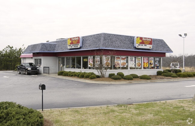


Property Detail
587 Carrollton St
T04-0070049
HARDEES/6.86AC-HWY 113 T35
Restaurantdrivein
Carroll
GC
Georgia
B and X Area of moderate flood hazard, usually the area between the limits of the 100-year and 500-year floods.
6.86 AC
2025
Villa Rica/W Outlying
2025
Atlanta
910203
Atlanta-Sandy Springs-Roswell, GA
3,096 SF
NEARBY LISTINGS FOR SALE OR LEASE
-
-
View all Temple listings for sale on LoopNet.com
DEMOGRAPHICS near 587 Carrollton St
1 mile
3 mile
5 mile
2025 Total Population
1,927
11,680
23,536
2030 Population
2,074
12,614
25,378
Pop Growth 2025-2030
+ 7.63%
+ 8.00%
+ 7.83%
Average Age
37
38
38
2025 Total Households
665
4,030
8,216
HH Growth 2025-2030
+ 7.67%
+ 7.99%
+ 7.84%
Median Household Inc
$87,725
$83,293
$81,440
Avg Household Size
2.90
2.90
2.80
2025 Avg HH Vehicles
2.00
2.00
2.00
Median Home Value
$301,342
$280,259
$275,134
Median Year Built
1996
1997
1996
Nearby Places
Map Layers
Map Styles
 Street
 Aerial
Layers
 Traffic
 Biking
Places
Listings with unknown addresses are not visible on the map
- Restaurants
- Banks
- Shops
- Fitness
- Groceries
PUBLIC TRANSPORTATION
AIRPORT
Hartsfield - Jackson Atlanta International
Drive
Walk
Distance
Hartsfield - Jackson Atlanta International
60 min
47.4 mi
Nearby Properties
Address
Land Use
TOTAL SIZE
Lot Size
Zoning
Address
Land Use
TOTAL SIZE
Lot Size
Zoning
228,640 SF
17.27 AC
I
Address
Land Use
TOTAL SIZE
Lot Size
Zoning
280,118 SF
22.72 AC
I
Address
Land Use
TOTAL SIZE
Lot Size
Zoning
83,083 SF
11.21 AC
GC
Address
Land Use
TOTAL SIZE
Lot Size
Zoning
138,953 SF
18.97 AC
RD
Address
Land Use
TOTAL SIZE
Lot Size
Zoning
25,562 SF
7.81 AC
R14
Address
Land Use
TOTAL SIZE
Lot Size
Zoning
102,856 SF
13.13 AC
I
Address
Land Use
TOTAL SIZE
Lot Size
Zoning
17,182 SF
27.39 AC
GC
Address
Land Use
TOTAL SIZE
Lot Size
Zoning
138.26 AC
A
Address
Land Use
TOTAL SIZE
Lot Size
Zoning
24,904 SF
9.93 AC
GC
Address
Land Use
TOTAL SIZE
Lot Size
Zoning
86,167 SF
6.90 AC
RD
Address
Land Use
TOTAL SIZE
Lot Size
Zoning
37,169 SF
3.18 AC
I
Address
Land Use
TOTAL SIZE
Lot Size
Zoning
2,220 SF
8.88 AC
C
Address
Land Use
TOTAL SIZE
Lot Size
Zoning
15.18 AC
001
Address
Land Use
TOTAL SIZE
Lot Size
Zoning
4,345 SF
1.75 AC
GC
Address
Land Use
TOTAL SIZE
Lot Size
Zoning
67.54 AC
A
Address
Land Use
TOTAL SIZE
Lot Size
Zoning
65.39 AC
A
Address
Land Use
TOTAL SIZE
Lot Size
Zoning
4,328 SF
5.76 AC
C
Address
Land Use
TOTAL SIZE
Lot Size
Zoning
13,614 SF
2.24 AC
R14
Address
Land Use
TOTAL SIZE
Lot Size
Zoning
27,834 SF
15.28 AC
001
Address
Land Use
TOTAL SIZE
Lot Size
Zoning
53.40 AC
A
Address
Land Use
TOTAL SIZE
Lot Size
Zoning
4,098 SF
1.06 AC
GC
Address
Land Use
TOTAL SIZE
Lot Size
Zoning
10,584 SF
2.99 AC
DCD
Address
Land Use
TOTAL SIZE
Lot Size
Zoning
17,500 SF
8.93 AC
I
Address
Land Use
TOTAL SIZE
Lot Size
Zoning
27,150 SF
3.71 AC
LI
Address
Land Use
TOTAL SIZE
Lot Size
Zoning
3,709 SF
1.06 AC
DCD
Address
Land Use
TOTAL SIZE
Lot Size
Zoning
14,400 SF
2.48 AC
CG
Address
Land Use
TOTAL SIZE
Lot Size
Zoning
26.26 AC
I
Address
Land Use
TOTAL SIZE
Lot Size
Zoning
2,928 SF
0.98 AC
GC
Address
Land Use
TOTAL SIZE
Lot Size
Zoning
40,215 SF
21.92 AC
I
The World's #1 Commercial Real Estate Marketplace
Connect with us
© 2026 CoStar Group
The information above has been obtained from sources believed reliable. While we do not doubt its accuracy we have not verified it and make no guarantee, warranty or representation about it. It is your responsibility to independently confirm its accuracy and completeness. Any projections, opinions, assumptions, or estimates used are for example only and do not represent the current or future performance of the property. The value of this transaction to you depends on tax and other factors which should be evaluated by your tax, financial, and legal advisors. You and your advisors should conduct a careful, independent investigation of the property to determine to your satisfaction the suitability of the property for your needs.