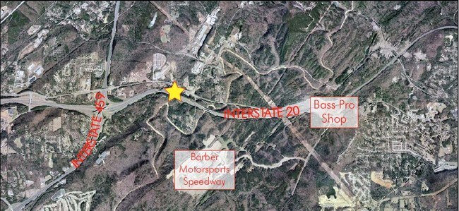
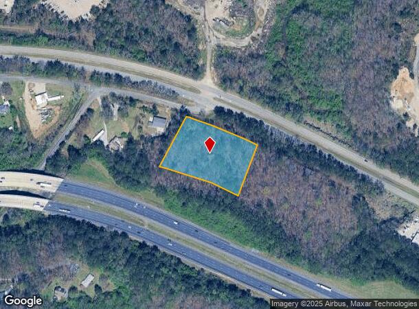
Property Record
5873 Highway 78 E, Birmingham, AL 35210

NEARBY LISTINGS FOR SALE OR LEASE
Property Detail
5873 Highway 78 E
24-00-15-4-000-008.000
COM AT SE COR OF SE 1/4 TH N 205 FT TH NWLY ALONG R/W 1190 FT TO POB TH SW 270 FT TH NWLY 400 FT TH NELY 275 FT TH SELY 360 FT TO POB
Vacantlandnec
Jefferson
X
Alabama
01073C0417H
2.30 AC
2023
Trussville
2024
Birmingham
0127012060
Birmingham-Hoover, AL
DEMOGRAPHICS near 5873 Highway 78 E
1 Mile
3 Mile
5 Mile
2024 Total Population
821
6,159
40,900
2029 Population
807
6,022
39,807
Pop Growth 2024-2029
(1.71%)
(2.22%)
(2.67%)
Average Age
42
41
40
2024 Total Households
243
2,332
16,054
HH Growth 2024-2029
(2.47%)
(2.40%)
(2.73%)
Median Household Inc
$58,845
$71,761
$70,282
Avg Household Size
2.70
2.50
2.50
2024 Avg HH Vehicles
2.00
2.00
2.00
Median Home Value
$152,127
$221,209
$211,747
Median Year Built
1975
1983
1977
Nearby Places
Map Layers
Map Styles
 Street
 Aerial
- Restaurants
- Banks
- Shops
- Fitness
- Groceries
PUBLIC TRANSPORTATION
AIRPORT
Birmingham-Shuttlesworth International
DRIVE
WALK
Distance
Birmingham-Shuttlesworth International
15 min
9.8 mi
Freight Ports
Port of Mobile
DRIVE
WALK
Distance
Port of Mobile
288 min
262.9 mi
SALE & LEASE HISTORY
LISTING DATE
SALE/LEASE

Feb 28, 2025
For Sale
Feb 03, 2021
For Sale
Nearby Properties
Address
Land Use
TOTAL SIZE
Lot Size
Zoning
Address
Land Use
TOTAL SIZE
Lot Size
Zoning
174,247 SF
46.70 AC
INST
Address
Land Use
TOTAL SIZE
Lot Size
Zoning
356,967 SF
34.71 AC
I3S&
Address
Land Use
TOTAL SIZE
Lot Size
Zoning
146,331 SF
161 AC
I3S&
Address
Land Use
TOTAL SIZE
Lot Size
Zoning
158,161 SF
15.48 AC
C1
Address
Land Use
TOTAL SIZE
Lot Size
Zoning
125,324 SF
53 AC
INST
Address
Land Use
TOTAL SIZE
Lot Size
Zoning
146,749 SF
23.99 AC
B2
Address
Land Use
TOTAL SIZE
Lot Size
Zoning
137,168 SF
63 AC
A1
Address
Land Use
TOTAL SIZE
Lot Size
Zoning
52,828 SF
12.70 AC
B2
Address
Land Use
TOTAL SIZE
Lot Size
Zoning
168,744 SF
8.46 AC
I1
Address
Land Use
TOTAL SIZE
Lot Size
Zoning
43,566 SF
18.99 AC
C1
Address
Land Use
TOTAL SIZE
Lot Size
Zoning
194,730 SF
25 AC
I-1
Address
Land Use
TOTAL SIZE
Lot Size
Zoning
113,014 SF
8 AC
I1
Address
Land Use
TOTAL SIZE
Lot Size
Zoning
28,666 SF
4.41 AC
B2
Address
Land Use
TOTAL SIZE
Lot Size
Zoning
64,859 SF
105 AC
INST
Address
Land Use
TOTAL SIZE
Lot Size
Zoning
76,037 SF
32.40 AC
A1
Address
Land Use
TOTAL SIZE
Lot Size
Zoning
14,432 SF
38.50 AC
I1
Address
Land Use
TOTAL SIZE
Lot Size
Zoning
170,783 SF
105 AC
PR1
Address
Land Use
TOTAL SIZE
Lot Size
Zoning
40,759 SF
5.40 AC
C-1
Address
Land Use
TOTAL SIZE
Lot Size
Zoning
22,866 SF
4.41 AC
A1
Address
Land Use
TOTAL SIZE
Lot Size
Zoning
22.57 AC
I3
Address
Land Use
TOTAL SIZE
Lot Size
Zoning
31,128 SF
6.32 AC
C1
Address
Land Use
TOTAL SIZE
Lot Size
Zoning
46,981 SF
92 AC
I3S&
Address
Land Use
TOTAL SIZE
Lot Size
Zoning
58,200 SF
7.20 AC
I1
Address
Land Use
TOTAL SIZE
Lot Size
Zoning
108,922 SF
7.70 AC
QM-1
Address
Land Use
TOTAL SIZE
Lot Size
Zoning
29,057 SF
103 AC
A1
Address
Land Use
TOTAL SIZE
Lot Size
Zoning
130,000 SF
3.75 AC
I3
Address
Land Use
TOTAL SIZE
Lot Size
Zoning
55,590 SF
77 AC
CC1
Address
Land Use
TOTAL SIZE
Lot Size
Zoning
53,228 SF
9 AC
C1R1
Address
Land Use
TOTAL SIZE
Lot Size
Zoning
12,960 SF
4.45 AC
B2
Address
Land Use
TOTAL SIZE
Lot Size
Zoning
71,350 SF
8.55 AC
I1
The World's #1 Commercial Real Estate Marketplace
Connect with us
© 2025 CoStar Group
The information above has been obtained from sources believed reliable. While we do not doubt its accuracy we have not verified it and make no guarantee, warranty or representation about it. It is your responsibility to independently confirm its accuracy and completeness. Any projections, opinions, assumptions, or estimates used are for example only and do not represent the current or future performance of the property. The value of this transaction to you depends on tax and other factors which should be evaluated by your tax, financial, and legal advisors. You and your advisors should conduct a careful, independent investigation of the property to determine to your satisfaction the suitability of the property for your needs.