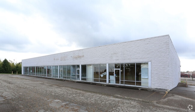
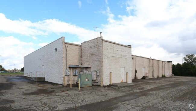
Property Record
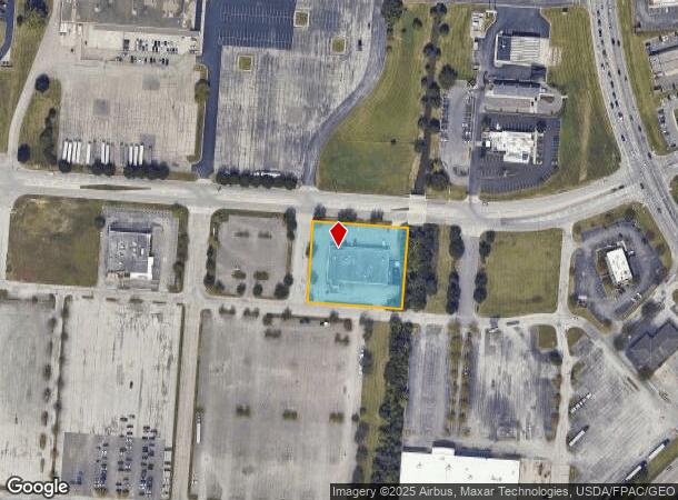
5875 Chantry Dr, Columbus, OH 43232
NEARBY LISTINGS FOR SALE OR LEASE
Property Detail
5875 Chantry Dr
010-214971
BRICE ROAD R21 T12 S26 1/2S45 1.293 ACRES
Regionalshoppingcenterormallwithanchorstore
Franklin
X
Ohio
39045C0025G
1.29 AC
2024
East
2025
Columbus
009392
Columbus, OH
15,341 SF
DEMOGRAPHICS near 5875 Chantry Dr
1 Mile
3 Mile
5 Mile
2024 Total Population
12,577
99,430
235,056
2029 Population
12,536
100,355
238,550
Pop Growth 2024-2029
(0.33%)
+ 0.93%
+ 1.49%
Average Age
35
37
38
2024 Total Households
4,746
39,514
92,506
HH Growth 2024-2029
(0.46%)
+ 0.79%
+ 1.32%
Median Household Inc
$54,321
$53,177
$58,237
Avg Household Size
2.60
2.40
2.50
2024 Avg HH Vehicles
2.00
2.00
2.00
Median Home Value
$154,652
$163,780
$193,661
Median Year Built
1986
1978
1981
Nearby Places
Map Layers
Map Styles
 Street
 Aerial
- Restaurants
- Banks
- Shops
- Fitness
- Groceries
PUBLIC TRANSPORTATION
AIRPORT
John Glenn Columbus International
DRIVE
WALK
Distance
John Glenn Columbus International
17 min
10.2 mi
Rickenbacker International
DRIVE
WALK
Distance
Rickenbacker International
20 min
12.5 mi
Freight Ports
Port of Toledo
DRIVE
WALK
Distance
Port of Toledo
193 min
154.0 mi
SALE & LEASE HISTORY
LISTING DATE
SALE/LEASE

Jan 17, 2017
For Lease
Nearby Properties
Address
Land Use
TOTAL SIZE
Lot Size
Zoning
Address
Land Use
TOTAL SIZE
Lot Size
Zoning
106,679 SF
25.60 AC
Address
Land Use
TOTAL SIZE
Lot Size
Zoning
61,542 SF
29.16 AC
Address
Land Use
TOTAL SIZE
Lot Size
Zoning
147,649 SF
5.15 AC
Address
Land Use
TOTAL SIZE
Lot Size
Zoning
65,760 SF
25.37 AC
Address
Land Use
TOTAL SIZE
Lot Size
Zoning
230,994 SF
23.82 AC
Address
Land Use
TOTAL SIZE
Lot Size
Zoning
307,190 SF
55.18 AC
Address
Land Use
TOTAL SIZE
Lot Size
Zoning
181,204 SF
22.90 AC
Address
Land Use
TOTAL SIZE
Lot Size
Zoning
281,803 SF
20 AC
Address
Land Use
TOTAL SIZE
Lot Size
Zoning
60,005 SF
0.35 AC
Address
Land Use
TOTAL SIZE
Lot Size
Zoning
46,340 SF
10.58 AC
Address
Land Use
TOTAL SIZE
Lot Size
Zoning
66,177 SF
11.17 AC
Address
Land Use
TOTAL SIZE
Lot Size
Zoning
13,591 SF
20.83 AC
Address
Land Use
TOTAL SIZE
Lot Size
Zoning
70,258 SF
23.32 AC
Address
Land Use
TOTAL SIZE
Lot Size
Zoning
2,117,753 SF
117.95 AC
Address
Land Use
TOTAL SIZE
Lot Size
Zoning
125,575 SF
9.40 AC
Address
Land Use
TOTAL SIZE
Lot Size
Zoning
188,305 SF
27.46 AC
Address
Land Use
TOTAL SIZE
Lot Size
Zoning
497,642 SF
29.98 AC
Address
Land Use
TOTAL SIZE
Lot Size
Zoning
158,325 SF
34.39 AC
Address
Land Use
TOTAL SIZE
Lot Size
Zoning
29,311 SF
24.95 AC
Address
Land Use
TOTAL SIZE
Lot Size
Zoning
159,719 SF
36.24 AC
Address
Land Use
TOTAL SIZE
Lot Size
Zoning
33,230 SF
28.79 AC
Address
Land Use
TOTAL SIZE
Lot Size
Zoning
175,313 SF
27.10 AC
Address
Land Use
TOTAL SIZE
Lot Size
Zoning
47,064 SF
32.95 AC
Address
Land Use
TOTAL SIZE
Lot Size
Zoning
29,569 SF
0.34 AC
Address
Land Use
TOTAL SIZE
Lot Size
Zoning
32,864 SF
2.82 AC
Address
Land Use
TOTAL SIZE
Lot Size
Zoning
96,372 SF
44.58 AC
Address
Land Use
TOTAL SIZE
Lot Size
Zoning
70,192 SF
20.22 AC
Address
Land Use
TOTAL SIZE
Lot Size
Zoning
105,542 SF
13.90 AC
Address
Land Use
TOTAL SIZE
Lot Size
Zoning
52,181 SF
26.64 AC
Address
Land Use
TOTAL SIZE
Lot Size
Zoning
172,822 SF
48.21 AC
The World's #1 Commercial Real Estate Marketplace
Connect with us
© 2026 CoStar Group
The information above has been obtained from sources believed reliable. While we do not doubt its accuracy we have not verified it and make no guarantee, warranty or representation about it. It is your responsibility to independently confirm its accuracy and completeness. Any projections, opinions, assumptions, or estimates used are for example only and do not represent the current or future performance of the property. The value of this transaction to you depends on tax and other factors which should be evaluated by your tax, financial, and legal advisors. You and your advisors should conduct a careful, independent investigation of the property to determine to your satisfaction the suitability of the property for your needs.