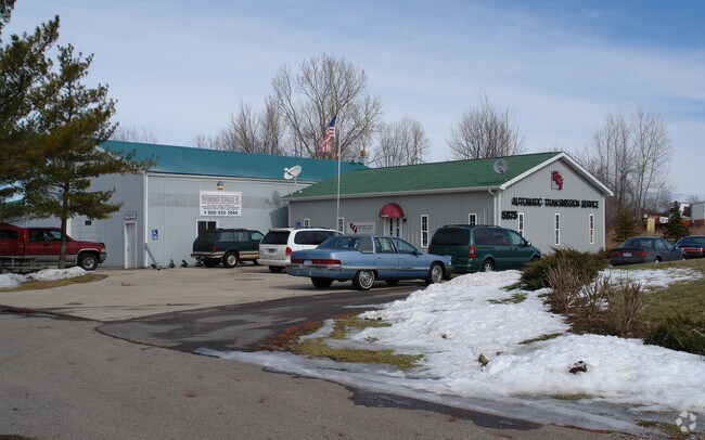
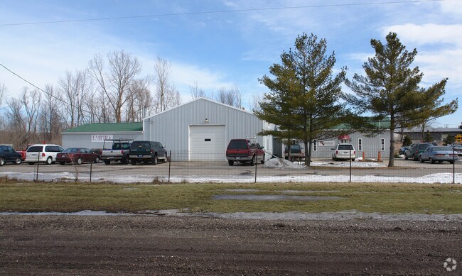
Property Record
5875 N Michigan Rd, Dimondale, MI 48821

Save to a Folder
{{folder.Name}}
{{folder.ListingIds.length}} Properties
{{folder.ListingIds.length}} Property
Create a New Folder
Property Detail
5875 N Michigan Rd
080-013-200-025-00
COM NE COR SEC 13, S 1 DEG 38'30"W ON E SEC LINE 887.26 FT, N 88 DEG 21'30"W 542.71 FT TO C/L M-99 & POB, S 52 DEG 30'W ALONG
Officebuilding
Eaton
M-1
Michigan
B and X Area of moderate flood hazard, usually the area between the limits of the 100-year and 500-year floods.
1.30 AC
2025
Outlying Eaton County
2026
West Michigan
021402
Lansing-East Lansing, MI
5,048 SF
NEARBY LISTINGS FOR SALE OR LEASE
DEMOGRAPHICS near 5875 N Michigan Rd
1 mile
3 mile
5 mile
2025 Total Population
1,210
31,825
86,146
2030 Population
1,225
31,929
86,807
Pop Growth 2025-2030
+ 1.24%
+ 0.33%
+ 0.77%
Average Age
38
39
40
2025 Total Households
439
12,380
36,274
HH Growth 2025-2030
+ 1.14%
+ 0.26%
+ 0.77%
Median Household Inc
$92,934
$65,033
$62,474
Avg Household Size
2.60
2.50
2.30
2025 Avg HH Vehicles
2.00
2.00
2.00
Median Home Value
$195,901
$173,810
$163,099
Median Year Built
1986
1972
1969
Nearby Places
Map Layers
Map Styles
 Street
 Aerial
Layers
 Traffic
 Biking
Places
Listings with unknown addresses are not visible on the map
- Restaurants
- Banks
- Shops
- Fitness
- Groceries
PUBLIC TRANSPORTATION
AIRPORT
Capital Region International
Drive
Walk
Distance
Capital Region International
19 min
9.6 mi
Nearby Properties
Address
Land Use
TOTAL SIZE
Lot Size
Zoning
Address
Land Use
TOTAL SIZE
Lot Size
Zoning
75,476 SF
17.70 AC
Address
Land Use
TOTAL SIZE
Lot Size
Zoning
50,364 SF
25.57 AC
M-1
Address
Land Use
TOTAL SIZE
Lot Size
Zoning
14.78 AC
F COMM
Address
Land Use
TOTAL SIZE
Lot Size
Zoning
3,528 SF
230 AC
Address
Land Use
TOTAL SIZE
Lot Size
Zoning
8,469 SF
160 AC
Address
Land Use
TOTAL SIZE
Lot Size
Zoning
29,965 SF
4.52 AC
A-1
Address
Land Use
TOTAL SIZE
Lot Size
Zoning
1,496 SF
47.39 AC
RM-1
Address
Land Use
TOTAL SIZE
Lot Size
Zoning
3,006 SF
136 AC
DM-1 RE
Address
Land Use
TOTAL SIZE
Lot Size
Zoning
20,834 SF
11.85 AC
F COMM
Address
Land Use
TOTAL SIZE
Lot Size
Zoning
140,841 SF
199 AC
CUP
Address
Land Use
TOTAL SIZE
Lot Size
Zoning
7,689 SF
148.47 AC
DM-1 RE
Address
Land Use
TOTAL SIZE
Lot Size
Zoning
126,015 SF
176 AC
CUP
Address
Land Use
TOTAL SIZE
Lot Size
Zoning
11.03 AC
Address
Land Use
TOTAL SIZE
Lot Size
Zoning
44,000 SF
5 AC
M-1
Address
Land Use
TOTAL SIZE
Lot Size
Zoning
71,900 SF
5.08 AC
NONE
Address
Land Use
TOTAL SIZE
Lot Size
Zoning
43,150 SF
20.31 AC
NONE
Address
Land Use
TOTAL SIZE
Lot Size
Zoning
90,078 SF
164 AC
CUP
Address
Land Use
TOTAL SIZE
Lot Size
Zoning
1,800 SF
80 AC
CUP
Address
Land Use
TOTAL SIZE
Lot Size
Zoning
38,338 SF
2.12 AC
B-2
Address
Land Use
TOTAL SIZE
Lot Size
Zoning
5,201 SF
78 AC
Address
Land Use
TOTAL SIZE
Lot Size
Zoning
74,798 SF
80 AC
Address
Land Use
TOTAL SIZE
Lot Size
Zoning
73,136 SF
78 AC
CUP
Address
Land Use
TOTAL SIZE
Lot Size
Zoning
73,742 SF
76 AC
Address
Land Use
TOTAL SIZE
Lot Size
Zoning
74,461 SF
76 AC
CUP
Address
Land Use
TOTAL SIZE
Lot Size
Zoning
60,000 SF
45 AC
DM-1 RE
Address
Land Use
TOTAL SIZE
Lot Size
Zoning
3.03 AC
H LT IN
Address
Land Use
TOTAL SIZE
Lot Size
Zoning
62,100 SF
9.57 AC
DM-1 RE
Address
Land Use
TOTAL SIZE
Lot Size
Zoning
68,292 SF
74 AC
Address
Land Use
TOTAL SIZE
Lot Size
Zoning
53.59 AC
DM-1 RE
Address
Land Use
TOTAL SIZE
Lot Size
Zoning
31,600 SF
3.05 AC
M-1
The World's #1 Commercial Real Estate Marketplace
Connect with us
© 2026 CoStar Group
The information above has been obtained from sources believed reliable. While we do not doubt its accuracy we have not verified it and make no guarantee, warranty or representation about it. It is your responsibility to independently confirm its accuracy and completeness. Any projections, opinions, assumptions, or estimates used are for example only and do not represent the current or future performance of the property. The value of this transaction to you depends on tax and other factors which should be evaluated by your tax, financial, and legal advisors. You and your advisors should conduct a careful, independent investigation of the property to determine to your satisfaction the suitability of the property for your needs.