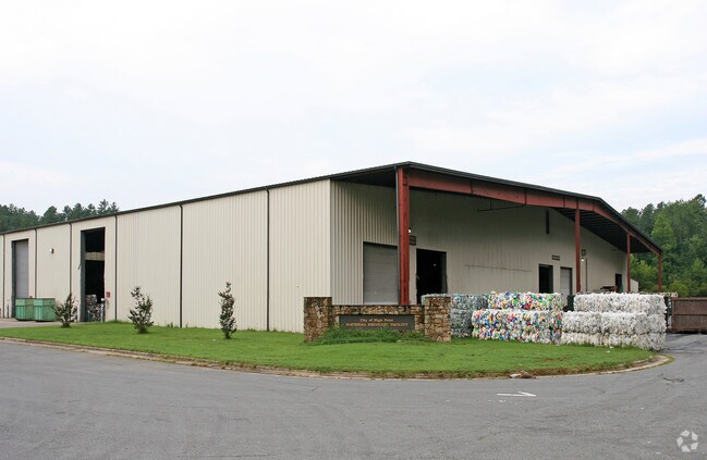
Property Record
5875 Riverdale Dr, Jamestown, NC 27282


Save to a Folder
{{folder.Name}}
{{folder.ListingIds.length}} Properties
{{folder.ListingIds.length}} Property
Create a New Folder
Property Detail
5875 Riverdale Dr
0209709
CHP RECYCLING FACILITY PL:169-64
Industrialgeneral
Guilford
HI
North Carolina
B and X Area of moderate flood hazard, usually the area between the limits of the 100-year and 500-year floods.
6
0
11.66 AC
2025
High Point/SW Guilford Cty
016600
Greensboro/Winston-Salem
64,140 SF
Greensboro-High Point, NC
NEARBY LISTINGS FOR SALE OR LEASE
-
-
View all Jamestown listings for sale on LoopNet.com
DEMOGRAPHICS near 5875 Riverdale Dr
1 mile
3 mile
5 mile
2025 Total Population
213
13,194
64,038
2030 Population
219
13,585
66,249
Pop Growth 2025-2030
+ 2.82%
+ 2.96%
+ 3.45%
Average Age
43
40
40
2025 Total Households
87
5,167
25,328
HH Growth 2025-2030
+ 2.30%
+ 3.15%
+ 3.62%
Median Household Inc
$51,111
$56,598
$52,767
Avg Household Size
2.50
2.50
2.40
2025 Avg HH Vehicles
2.00
2.00
2.00
Median Home Value
$206,667
$204,244
$202,981
Median Year Built
1967
1981
1977
Nearby Places
Map Layers
Map Styles
 Street
 Aerial
Layers
 Traffic
 Biking
Places
Listings with unknown addresses are not visible on the map
- Restaurants
- Banks
- Shops
- Fitness
- Groceries
PUBLIC TRANSPORTATION
COMMUTER RAIL
High Point Station (Piedmont - North Carolina by Train (NC Train))
Drive
Walk
Distance
High Point Station (Piedmont - North Carolina by Train (NC Train))
15 min
6.2 mi
AIRPORT
Piedmont Triad International
Drive
Walk
Distance
Piedmont Triad International
32 min
15.7 mi
Nearby Properties
Address
Land Use
TOTAL SIZE
Lot Size
Zoning
Address
Land Use
TOTAL SIZE
Lot Size
Zoning
1,259,149 SF
46.12 AC
HB
Address
Land Use
TOTAL SIZE
Lot Size
Zoning
299,349 SF
21.76 AC
RM-16
Address
Land Use
TOTAL SIZE
Lot Size
Zoning
473,040 SF
63.60 AC
AG
Address
Land Use
TOTAL SIZE
Lot Size
Zoning
113,866 SF
11.53 AC
LI
Address
Land Use
TOTAL SIZE
Lot Size
Zoning
159,944 SF
13.95 AC
RS-40
Address
Land Use
TOTAL SIZE
Lot Size
Zoning
89,183 SF
17.12 AC
GB
Address
Land Use
TOTAL SIZE
Lot Size
Zoning
105,050 SF
9.58 AC
RM-16
Address
Land Use
TOTAL SIZE
Lot Size
Zoning
13,311 SF
162.92 AC
HI
Address
Land Use
TOTAL SIZE
Lot Size
Zoning
65,733 SF
124.36 AC
HI
Address
Land Use
TOTAL SIZE
Lot Size
Zoning
66,487 SF
10.16 AC
LI
Address
Land Use
TOTAL SIZE
Lot Size
Zoning
35,611 SF
8.92 AC
LI
Address
Land Use
TOTAL SIZE
Lot Size
Zoning
189,060 SF
17.64 AC
LI
Address
Land Use
TOTAL SIZE
Lot Size
Zoning
33,470 SF
30.41 AC
HI
Address
Land Use
TOTAL SIZE
Lot Size
Zoning
152,260 SF
20.59 AC
LI
Address
Land Use
TOTAL SIZE
Lot Size
Zoning
41,876 SF
21 AC
R-5
Address
Land Use
TOTAL SIZE
Lot Size
Zoning
2,817 SF
101.78 AC
HI
Address
Land Use
TOTAL SIZE
Lot Size
Zoning
48,554 SF
5.29 AC
LB
Address
Land Use
TOTAL SIZE
Lot Size
Zoning
19,239 SF
18 AC
R-40
Address
Land Use
TOTAL SIZE
Lot Size
Zoning
30,720 SF
5.57 AC
RM-16
Address
Land Use
TOTAL SIZE
Lot Size
Zoning
38,565 SF
4.01 AC
GB
Address
Land Use
TOTAL SIZE
Lot Size
Zoning
120,500 SF
10.01 AC
LI
Address
Land Use
TOTAL SIZE
Lot Size
Zoning
63,030 SF
9.63 AC
LI
Address
Land Use
TOTAL SIZE
Lot Size
Zoning
13,524 SF
16.93 AC
LI
Address
Land Use
TOTAL SIZE
Lot Size
Zoning
14,960 SF
16.30 AC
R-40
Address
Land Use
TOTAL SIZE
Lot Size
Zoning
146,489 SF
15.32 AC
HI
Address
Land Use
TOTAL SIZE
Lot Size
Zoning
7,694 SF
154.79 AC
AG
Address
Land Use
TOTAL SIZE
Lot Size
Zoning
172.61 AC
HI
Address
Land Use
TOTAL SIZE
Lot Size
Zoning
7,882 SF
20.63 AC
CU LI
Address
Land Use
TOTAL SIZE
Lot Size
Zoning
15,218 SF
19.86 AC
LI
The World's #1 Commercial Real Estate Marketplace
Connect with us
© 2026 CoStar Group
The information above has been obtained from sources believed reliable. While we do not doubt its accuracy we have not verified it and make no guarantee, warranty or representation about it. It is your responsibility to independently confirm its accuracy and completeness. Any projections, opinions, assumptions, or estimates used are for example only and do not represent the current or future performance of the property. The value of this transaction to you depends on tax and other factors which should be evaluated by your tax, financial, and legal advisors. You and your advisors should conduct a careful, independent investigation of the property to determine to your satisfaction the suitability of the property for your needs.