Property Record
5875 Sw 6Th Pl, Ocala, FL 34474
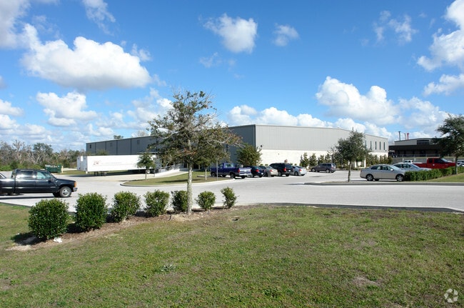

Property Detail
5875 Sw 6Th Pl
2318-007-005
SEC 16 TWP 15 RGE 21 PLAT BOOK U PAGE 074 OCALA AIRPORT COMMERCE CENTER BLK G LOT 5
Warehouse
Marion
M1
Florida
A Areas with a 1% annual chance of flooding and a 26% chance of flooding over the life of a 30-year mortgage.
5
2025
5.39 AC
2025
Greater Ocala
002504
Ocala
44,975 SF
Ocala, FL
NEARBY LISTINGS FOR SALE OR LEASE
DEMOGRAPHICS near 5875 Sw 6Th Pl
1 mile
3 mile
5 mile
2025 Total Population
999
21,857
54,415
2030 Population
1,127
24,503
61,461
Pop Growth 2025-2030
+ 12.81%
+ 12.11%
+ 12.95%
Average Age
36
43
44
2025 Total Households
335
8,669
22,682
HH Growth 2025-2030
+ 13.13%
+ 12.65%
+ 13.41%
Median Household Inc
$48,079
$63,750
$56,085
Avg Household Size
2.50
2.30
2.20
2025 Avg HH Vehicles
1.00
1.00
2.00
Median Home Value
$158,888
$273,270
$283,185
Median Year Built
1984
1994
1995
Nearby Places
Map Layers
Map Styles
 Street
 Aerial
Layers
 Traffic
 Biking
Places
Listings with unknown addresses are not visible on the map
- Restaurants
- Banks
- Shops
- Fitness
- Groceries
Nearby Properties
Address
Land Use
TOTAL SIZE
Lot Size
Zoning
Address
Land Use
TOTAL SIZE
Lot Size
Zoning
794,310 SF
259.94 AC
PUD
Address
Land Use
TOTAL SIZE
Lot Size
Zoning
2,015,469 SF
169.30 AC
M1
Address
Land Use
TOTAL SIZE
Lot Size
Zoning
704,765 SF
71.04 AC
GU
Address
Land Use
TOTAL SIZE
Lot Size
Zoning
493,261 SF
126.01 AC
R3
Address
Land Use
TOTAL SIZE
Lot Size
Zoning
85,986 SF
15.68 AC
PUD
Address
Land Use
TOTAL SIZE
Lot Size
Zoning
446,764 SF
138.06 AC
GU
Address
Land Use
TOTAL SIZE
Lot Size
Zoning
192,480 SF
23.19 AC
R3
Address
Land Use
TOTAL SIZE
Lot Size
Zoning
164,363 SF
16.51 AC
R3
Address
Land Use
TOTAL SIZE
Lot Size
Zoning
322,193 SF
70.13 AC
INST
Address
Land Use
TOTAL SIZE
Lot Size
Zoning
152,355 SF
973.50 AC
GU
Address
Land Use
TOTAL SIZE
Lot Size
Zoning
403,023 SF
47.47 AC
M1
Address
Land Use
TOTAL SIZE
Lot Size
Zoning
62,164 SF
27.64 AC
PD
Address
Land Use
TOTAL SIZE
Lot Size
Zoning
65,570 SF
18.96 AC
PD
Address
Land Use
TOTAL SIZE
Lot Size
Zoning
422,369 SF
51.11 AC
M2
Address
Land Use
TOTAL SIZE
Lot Size
Zoning
60,816 SF
13.67 AC
PD
Address
Land Use
TOTAL SIZE
Lot Size
Zoning
604,920 SF
42.92 AC
M1
Address
Land Use
TOTAL SIZE
Lot Size
Zoning
194,275 SF
13.43 AC
M1
Address
Land Use
TOTAL SIZE
Lot Size
Zoning
392,617 SF
23.83 AC
M1
Address
Land Use
TOTAL SIZE
Lot Size
Zoning
113,501 SF
68.56 AC
INST
Address
Land Use
TOTAL SIZE
Lot Size
Zoning
482,618 SF
34.54 AC
M2
Address
Land Use
TOTAL SIZE
Lot Size
Zoning
364,404 SF
31.83 AC
M1
Address
Land Use
TOTAL SIZE
Lot Size
Zoning
92,095 SF
216.43 AC
M1
Address
Land Use
TOTAL SIZE
Lot Size
Zoning
360,450 SF
20 AC
M1
Address
Land Use
TOTAL SIZE
Lot Size
Zoning
65,882 SF
13.34 AC
R3
Address
Land Use
TOTAL SIZE
Lot Size
Zoning
146,091 SF
43.91 AC
M1
Address
Land Use
TOTAL SIZE
Lot Size
Zoning
37,601 SF
3.71 AC
B2
Address
Land Use
TOTAL SIZE
Lot Size
Zoning
124,812 SF
27.07 AC
PUD
Address
Land Use
TOTAL SIZE
Lot Size
Zoning
39,411 SF
3.35 AC
B2
Address
Land Use
TOTAL SIZE
Lot Size
Zoning
265,793 SF
30 AC
M1
Address
Land Use
TOTAL SIZE
Lot Size
Zoning
79,199 SF
13.54 AC
B2
The World's #1 Commercial Real Estate Marketplace
Connect with us
© 2026 CoStar Group
The information above has been obtained from sources believed reliable. While we do not doubt its accuracy we have not verified it and make no guarantee, warranty or representation about it. It is your responsibility to independently confirm its accuracy and completeness. Any projections, opinions, assumptions, or estimates used are for example only and do not represent the current or future performance of the property. The value of this transaction to you depends on tax and other factors which should be evaluated by your tax, financial, and legal advisors. You and your advisors should conduct a careful, independent investigation of the property to determine to your satisfaction the suitability of the property for your needs.