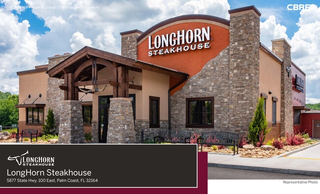
Property Record
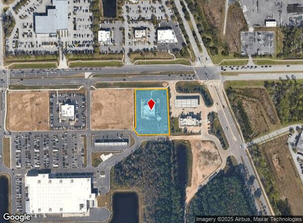
5877 E State Highway 100 E, Palm Coast, FL 32164

NEARBY LISTINGS FOR SALE OR LEASE
Property Detail
5877 E State Highway 100 E
Other Market Areas
Cornerstone At Seminole Woods
Deltona-Daytona Beach-Ormond Beach, FL
CORNERSTONE AT SEMINOLE WOODS MB 42 PG 44 LOT E (1.61 AC)
08-12-31-0650-000B0-0074
Flagler
Restaurantbuilding
Florida
2023
1
2025
1.61 AC
060208
Flagler County
13,174 SF
DEMOGRAPHICS near 5877 E State Highway 100 E
1 mile
3 mile
5 mile
2024 Total Population
1,983
19,746
65,519
2029 Population
2,483
24,311
80,238
Pop Growth 2024-2029
+ 25.21%
+ 23.12%
+ 22.47%
Average Age
45
45
47
2024 Total Households
1,002
8,048
26,677
HH Growth 2024-2029
+ 24.65%
+ 22.47%
+ 21.70%
Median Household Inc
$30,049
$59,065
$63,229
Avg Household Size
2.00
2.40
2.40
2024 Avg HH Vehicles
1.00
2.00
2.00
Median Home Value
$264,515
$264,063
$270,032
Median Year Built
2010
2005
2002
Nearby Places
Map Layers
Map Styles
 Street
 Aerial
Transit
 Traffic
 Biking
Places
Listings with unknown addresses are not visible on the map
- Restaurants
- Banks
- Shops
- Fitness
- Groceries
PUBLIC TRANSPORTATION
AIRPORT
Daytona Beach International
Drive
Walk
Distance
Daytona Beach International
33 min
25.1 mi
SALE & LEASE HISTORY
LISTING DATE
SALE/LEASE

Jun 05, 2024
For Sale
Nearby Properties
Address
Land Use
TOTAL SIZE
Lot Size
Zoning
Address
Land Use
TOTAL SIZE
Lot Size
Zoning
345,915 SF
94.85 AC
COM-2
Address
Land Use
TOTAL SIZE
Lot Size
Zoning
913,614 SF
85.53 AC
PSP
Address
Land Use
TOTAL SIZE
Lot Size
Zoning
142,653 SF
15.71 AC
PUD
Address
Land Use
TOTAL SIZE
Lot Size
Zoning
217,927 SF
1,165.37 AC
I-C
Address
Land Use
TOTAL SIZE
Lot Size
Zoning
280,742 SF
16.06 AC
MPD
Address
Land Use
TOTAL SIZE
Lot Size
Zoning
225,108 SF
41.71 AC
MPD
Address
Land Use
TOTAL SIZE
Lot Size
Zoning
141,171 SF
8.18 AC
MPD
Address
Land Use
TOTAL SIZE
Lot Size
Zoning
64,208 SF
8.41 AC
PSP
Address
Land Use
TOTAL SIZE
Lot Size
Zoning
904.63 AC
PUD
Address
Land Use
TOTAL SIZE
Lot Size
Zoning
69,026 SF
1.59 AC
MPD
Address
Land Use
TOTAL SIZE
Lot Size
Zoning
76,544 SF
48.85 AC
R/C
Address
Land Use
TOTAL SIZE
Lot Size
Zoning
459,150 SF
23.52 AC
COM-3
Address
Land Use
TOTAL SIZE
Lot Size
Zoning
124,911 SF
10.18 AC
PUD
Address
Land Use
TOTAL SIZE
Lot Size
Zoning
15.91 AC
PSP
Address
Land Use
TOTAL SIZE
Lot Size
Zoning
220,314 SF
17.41 AC
MPD
Address
Land Use
TOTAL SIZE
Lot Size
Zoning
82,459 SF
4.09 AC
MPD
Address
Land Use
TOTAL SIZE
Lot Size
Zoning
122,353 SF
17.97 AC
MPD
Address
Land Use
TOTAL SIZE
Lot Size
Zoning
208,450 SF
11.85 AC
MPD
Address
Land Use
TOTAL SIZE
Lot Size
Zoning
137,827 SF
7.66 AC
MPD
Address
Land Use
TOTAL SIZE
Lot Size
Zoning
45.82 AC
C-2
Address
Land Use
TOTAL SIZE
Lot Size
Zoning
68,684 SF
9.68 AC
MPD
Address
Land Use
TOTAL SIZE
Lot Size
Zoning
89,590 SF
9.90 AC
B-1
Address
Land Use
TOTAL SIZE
Lot Size
Zoning
220.05 AC
MPD
Address
Land Use
TOTAL SIZE
Lot Size
Zoning
42,025 SF
15.64 AC
MPD
Address
Land Use
TOTAL SIZE
Lot Size
Zoning
112,500 SF
5 AC
HC
Address
Land Use
TOTAL SIZE
Lot Size
Zoning
84,899 SF
10.35 AC
COM-2
Address
Land Use
TOTAL SIZE
Lot Size
Zoning
35,243 SF
8.45 AC
COM-3
Address
Land Use
TOTAL SIZE
Lot Size
Zoning
59,889 SF
0.75 AC
R-3A
Address
Land Use
TOTAL SIZE
Lot Size
Zoning
28,591 SF
3.84 AC
PUD
The World's #1 Commercial Real Estate Marketplace
Connect with us
© 2026 CoStar Group
The information above has been obtained from sources believed reliable. While we do not doubt its accuracy we have not verified it and make no guarantee, warranty or representation about it. It is your responsibility to independently confirm its accuracy and completeness. Any projections, opinions, assumptions, or estimates used are for example only and do not represent the current or future performance of the property. The value of this transaction to you depends on tax and other factors which should be evaluated by your tax, financial, and legal advisors. You and your advisors should conduct a careful, independent investigation of the property to determine to your satisfaction the suitability of the property for your needs.