Property Record
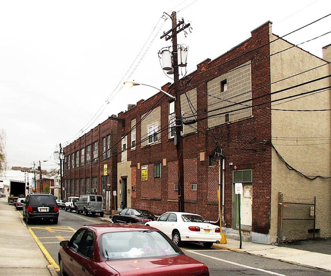
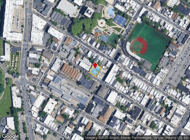
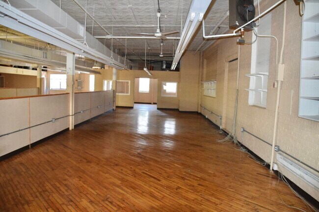
588 56Th St, West New York, NJ 07093

NEARBY LISTINGS FOR SALE OR LEASE
Property Detail
588 56Th St
12-00123-0000-00023
Hudson
Industrialgeneral
New Jersey
X
23
34003C0267H
0.17 AC
2024
Hudson Waterfront
2025
Northern New Jersey
016000
New York-Jersey City-White Plains, NY-NJ
13,248 SF
DEMOGRAPHICS near 588 56Th St
1 Mile
3 Mile
5 Mile
2024 Total Population
98,937
579,028
1,863,232
2029 Population
94,473
545,176
1,751,375
Pop Growth 2024-2029
(4.51%)
(5.85%)
(6.00%)
Average Age
40
41
41
2024 Total Households
36,719
263,576
874,515
HH Growth 2024-2029
(4.98%)
(6.33%)
(6.32%)
Median Household Inc
$59,191
$93,765
$94,389
Avg Household Size
2.60
2.10
2.00
2024 Avg HH Vehicles
1.00
1.00
.00
Median Home Value
$408,595
$779,223
$843,433
Median Year Built
1961
1960
1959
Nearby Places
Map Layers
Map Styles
 Street
 Aerial
- Restaurants
- Banks
- Shops
- Fitness
- Groceries
PUBLIC TRANSPORTATION
TRANSIT/SUBWAY
Bergenline Avenue (Tonnelle Avenue-Hoboken Terminal - Hudson-Bergen Light Rail (Hudson-Bergen Light Rail), West Side Avenue-Tonnelle Avenue - Hudson-Bergen Light Rail (Hudson-Bergen Light Rail))
DRIVE
WALK
Distance
Bergenline Avenue (Tonnelle Avenue-Hoboken Terminal - Hudson-Bergen Light Rail (Hudson-Bergen Light Rail), West Side Avenue-Tonnelle Avenue - Hudson-Bergen Light Rail (Hudson-Bergen Light Rail))
2 min
10 min
0.5 mi
Tonnelle Avenue (Tonnelle Avenue-Hoboken Terminal - Hudson-Bergen Light Rail (Hudson-Bergen Light Rail), West Side Avenue-Tonnelle Avenue - Hudson-Bergen Light Rail (Hudson-Bergen Light Rail))
DRIVE
WALK
Distance
Tonnelle Avenue (Tonnelle Avenue-Hoboken Terminal - Hudson-Bergen Light Rail (Hudson-Bergen Light Rail), West Side Avenue-Tonnelle Avenue - Hudson-Bergen Light Rail (Hudson-Bergen Light Rail))
3 min
17 min
0.9 mi
COMMUTER RAIL
New York Penn Station (NJT) (Montclair-Boonton Line - NJ Transit Commuter Rail (NJ Transit), Morris & Essex Gladstone Branch - NJ Transit Commuter Rail (NJ Transit), Morris & Essex Morristown Line - NJ Transit Commuter Rail (NJ Transit), North Jersey Coast Line - NJ Transit Commuter Rail (NJ Transit), Northeast Corridor Line - NJ Transit Commuter Rail (NJ Transit))
DRIVE
WALK
Distance
New York Penn Station (NJT) (Montclair-Boonton Line - NJ Transit Commuter Rail (NJ Transit), Morris & Essex Gladstone Branch - NJ Transit Commuter Rail (NJ Transit), Morris & Essex Morristown Line - NJ Transit Commuter Rail (NJ Transit), North Jersey Coast Line - NJ Transit Commuter Rail (NJ Transit), Northeast Corridor Line - NJ Transit Commuter Rail (NJ Transit))
14 min
5.0 mi
DRIVE
WALK
Distance
15 min
5.2 mi
AIRPORT
Newark Liberty International
DRIVE
WALK
Distance
Newark Liberty International
16 min
11.7 mi
LaGuardia
DRIVE
WALK
Distance
LaGuardia
31 min
13.8 mi
John F Kennedy International
DRIVE
WALK
Distance
John F Kennedy International
41 min
21.8 mi
Freight Ports
NY - Red Hook Container Terminal
DRIVE
WALK
Distance
NY - Red Hook Container Terminal
26 min
12.8 mi
SALE & LEASE HISTORY
LISTING DATE
SALE/LEASE

Sep 18, 2017
For Sale
Sep 15, 2021
For Sale
Sep 01, 2021
For Sale
Nov 27, 2019
For Sale
May 11, 2020
For Sale
Jun 11, 2021
For Lease
Jul 22, 2022
For Sale
Aug 22, 2017
For Sale
Apr 21, 2017
For Lease
Apr 21, 2017
For Sale
Nearby Properties
Address
Land Use
TOTAL SIZE
Lot Size
Zoning
Address
Land Use
TOTAL SIZE
Lot Size
Zoning
4,060,596 SF
22.09 AC
M2-3
Address
Land Use
TOTAL SIZE
Lot Size
Zoning
2,245,112 SF
2.02 AC
C6-6
Address
Land Use
TOTAL SIZE
Lot Size
Zoning
2,521,850 SF
1.59 AC
C6-4
Address
Land Use
TOTAL SIZE
Lot Size
Zoning
1,445,092 SF
3.10 AC
C6-4
Address
Land Use
TOTAL SIZE
Lot Size
Zoning
2,221,336 SF
1.55 AC
C6-4
Address
Land Use
TOTAL SIZE
Lot Size
Zoning
2,636,182 SF
2.35 AC
C65.5
Address
Land Use
TOTAL SIZE
Lot Size
Zoning
2,734,038 SF
4.24 AC
C52.5
Address
Land Use
TOTAL SIZE
Lot Size
Zoning
1,897,491 SF
2.06 AC
C52.5
Address
Land Use
TOTAL SIZE
Lot Size
Zoning
1,233,684 SF
16.94 AC
PARK
Address
Land Use
TOTAL SIZE
Lot Size
Zoning
1,638,259 SF
1.43 AC
C52.5
Address
Land Use
TOTAL SIZE
Lot Size
Zoning
2,360,627 SF
2.08 AC
C6-7
Address
Land Use
TOTAL SIZE
Lot Size
Zoning
1,642,675 SF
1.05 AC
C6-7
Address
Land Use
TOTAL SIZE
Lot Size
Zoning
1,984,228 SF
1.95 AC
C65.5
Address
Land Use
TOTAL SIZE
Lot Size
Zoning
1,962,900 SF
1.89 AC
C66.5
Address
Land Use
TOTAL SIZE
Lot Size
Zoning
1,946,157 SF
1.49 AC
C6-4
Address
Land Use
TOTAL SIZE
Lot Size
Zoning
1,842,991 SF
2.08 AC
C66.5
Address
Land Use
TOTAL SIZE
Lot Size
Zoning
2,535,958 SF
2.94 AC
C6-4
Address
Land Use
TOTAL SIZE
Lot Size
Zoning
1,178,640 SF
0.92 AC
C6-4
Address
Land Use
TOTAL SIZE
Lot Size
Zoning
1,751,641 SF
1.84 AC
C6-4
Address
Land Use
TOTAL SIZE
Lot Size
Zoning
1,613,847 SF
1.84 AC
C66.5
Address
Land Use
TOTAL SIZE
Lot Size
Zoning
1,596,521 SF
1.34 AC
C6-4
Address
Land Use
TOTAL SIZE
Lot Size
Zoning
Address
Land Use
TOTAL SIZE
Lot Size
Zoning
Address
Land Use
TOTAL SIZE
Lot Size
Zoning
Address
Land Use
TOTAL SIZE
Lot Size
Zoning
Address
Land Use
TOTAL SIZE
Lot Size
Zoning
1,805,894 SF
1.42 AC
C6-4
Address
Land Use
TOTAL SIZE
Lot Size
Zoning
264,420 SF
7.26 AC
C4-7
Address
Land Use
TOTAL SIZE
Lot Size
Zoning
431,963 SF
C67T
Address
Land Use
TOTAL SIZE
Lot Size
Zoning
1,649,604 SF
1.51 AC
C67T
Address
Land Use
TOTAL SIZE
Lot Size
Zoning
1,606,528 SF
1.84 AC
C6-6
The World's #1 Commercial Real Estate Marketplace
Connect with us
© 2025 CoStar Group
The information above has been obtained from sources believed reliable. While we do not doubt its accuracy we have not verified it and make no guarantee, warranty or representation about it. It is your responsibility to independently confirm its accuracy and completeness. Any projections, opinions, assumptions, or estimates used are for example only and do not represent the current or future performance of the property. The value of this transaction to you depends on tax and other factors which should be evaluated by your tax, financial, and legal advisors. You and your advisors should conduct a careful, independent investigation of the property to determine to your satisfaction the suitability of the property for your needs.