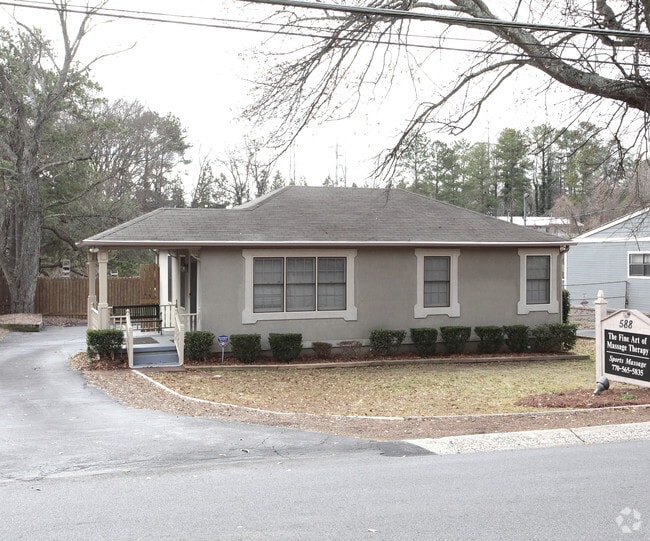
Property Record
588 Seminole Dr Ne, Marietta, GA 30060
Current Lease Availabilities
NEARBY LISTINGS FOR SALE OR LEASE
Property Detail
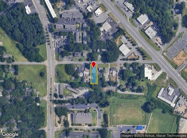
588 Seminole Dr Ne
Atlanta-Sandy Springs-Roswell, GA
Custer
16-1090-0-058-0
LOT 7 BLOCK D
Commercialnec
Cobb
AE
Georgia
13067C0108J
7
2025
0.32 AC
2025
Kennesaw/Town Center
030700
Atlanta
840 SF
DEMOGRAPHICS near 588 Seminole Dr Ne
1 Mile
3 Mile
5 Mile
2024 Total Population
7,518
68,521
194,654
2029 Population
7,711
70,149
198,684
Pop Growth 2024-2029
+ 2.57%
+ 2.38%
+ 2.07%
Average Age
38
38
38
2024 Total Households
2,903
27,386
76,677
HH Growth 2024-2029
+ 2.62%
+ 2.35%
+ 2.10%
Median Household Inc
$54,784
$68,306
$74,862
Avg Household Size
2.50
2.30
2.40
2024 Avg HH Vehicles
2.00
2.00
2.00
Median Home Value
$352,299
$347,829
$349,371
Median Year Built
1973
1982
1984
Nearby Places
- Restaurants
- Banks
- Shops
- Fitness
- Groceries
PUBLIC TRANSPORTATION
AIRPORT
Hartsfield - Jackson Atlanta International
DRIVE
WALK
Distance
Hartsfield - Jackson Atlanta International
38 min
27.9 mi
Freight Ports
Georgia Ports - Savannah
DRIVE
WALK
Distance
Georgia Ports - Savannah
301 min
267.2 mi
Nearby Properties
Address
Land Use
TOTAL SIZE
Lot Size
Zoning
Address
Land Use
TOTAL SIZE
Lot Size
Zoning
379,750 SF
11.14 AC
Address
Land Use
TOTAL SIZE
Lot Size
Zoning
578,456 SF
60 AC
RM-12
Address
Land Use
TOTAL SIZE
Lot Size
Zoning
385,954 SF
31 AC
RM-12
Address
Land Use
TOTAL SIZE
Lot Size
Zoning
452,366 SF
27.27 AC
PRD MF
Address
Land Use
TOTAL SIZE
Lot Size
Zoning
494,076 SF
33.30 AC
PRD MF
Address
Land Use
TOTAL SIZE
Lot Size
Zoning
300,105 SF
43.12 AC
RM-8
Address
Land Use
TOTAL SIZE
Lot Size
Zoning
183,262 SF
19.35 AC
RM-12
Address
Land Use
TOTAL SIZE
Lot Size
Zoning
8,000 SF
9.57 AC
PRD MF
Address
Land Use
TOTAL SIZE
Lot Size
Zoning
284,832 SF
19.56 AC
PRD MF
Address
Land Use
TOTAL SIZE
Lot Size
Zoning
243,574 SF
40.05 AC
RM-8
Address
Land Use
TOTAL SIZE
Lot Size
Zoning
129,168 SF
0.82 AC
OI
Address
Land Use
TOTAL SIZE
Lot Size
Zoning
285,846 SF
19.21 AC
PRD MF
Address
Land Use
TOTAL SIZE
Lot Size
Zoning
8,980 SF
51.17 AC
Address
Land Use
TOTAL SIZE
Lot Size
Zoning
228,652 SF
24.19 AC
RM-12
Address
Land Use
TOTAL SIZE
Lot Size
Zoning
509,792 SF
4.45 AC
OHR
Address
Land Use
TOTAL SIZE
Lot Size
Zoning
226,769 SF
13.40 AC
RM-16
Address
Land Use
TOTAL SIZE
Lot Size
Zoning
190,168 SF
14.60 AC
PRD MF
Address
Land Use
TOTAL SIZE
Lot Size
Zoning
240,628 SF
30.90 AC
RM-8
Address
Land Use
TOTAL SIZE
Lot Size
Zoning
222,906 SF
18.96 AC
RM-12
Address
Land Use
TOTAL SIZE
Lot Size
Zoning
232,894 SF
13.88 AC
PRD MF
Address
Land Use
TOTAL SIZE
Lot Size
Zoning
198,488 SF
16.79 AC
RM-12
Address
Land Use
TOTAL SIZE
Lot Size
Zoning
176,350 SF
19.56 AC
PRD MF
Address
Land Use
TOTAL SIZE
Lot Size
Zoning
143,362 SF
1.61 AC
OI
Address
Land Use
TOTAL SIZE
Lot Size
Zoning
254,242 SF
17.48 AC
RM-8
Address
Land Use
TOTAL SIZE
Lot Size
Zoning
431,575 SF
7.16 AC
OHR
Address
Land Use
TOTAL SIZE
Lot Size
Zoning
325,227 SF
22.42 AC
RM-12
Address
Land Use
TOTAL SIZE
Lot Size
Zoning
13.17 AC
LI
Address
Land Use
TOTAL SIZE
Lot Size
Zoning
180,508 SF
21.88 AC
RM-8
Address
Land Use
TOTAL SIZE
Lot Size
Zoning
147,029 SF
3.05 AC
PRD MF
Address
Land Use
TOTAL SIZE
Lot Size
Zoning
146,089 SF
10.29 AC
PRD MF
The World's #1 Commercial Real Estate Marketplace
Connect with us
© 2025 CoStar Group
The information above has been obtained from sources believed reliable. While we do not doubt its accuracy we have not verified it and make no guarantee, warranty or representation about it. It is your responsibility to independently confirm its accuracy and completeness. Any projections, opinions, assumptions, or estimates used are for example only and do not represent the current or future performance of the property. The value of this transaction to you depends on tax and other factors which should be evaluated by your tax, financial, and legal advisors. You and your advisors should conduct a careful, independent investigation of the property to determine to your satisfaction the suitability of the property for your needs.