Property Record
5883 W Michigan Ave, Jackson, MI 49201

Save to a Folder
{{folder.Name}}
{{folder.ListingIds.length}} Properties
{{folder.ListingIds.length}} Property
Create a New Folder
Property Detail
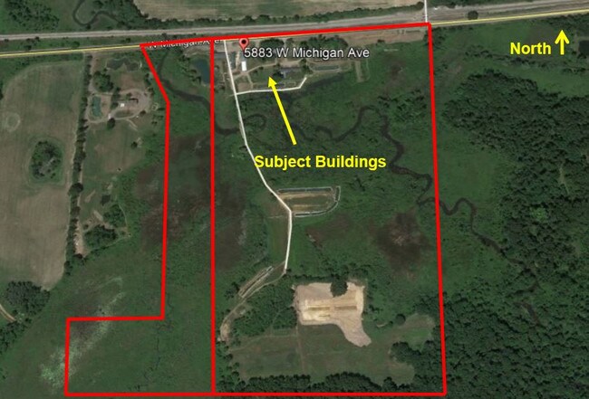
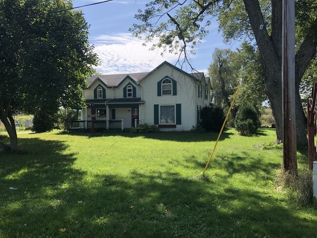
5883 W Michigan Ave
000-07-36-351-001-01
THE WEST 1/2 OF THSW 1/4 LYING S OF THE CLOF MICHIGAN AVE T2S R2W 69.99 AC M/L COMBINE ON 1/14/2014 FROM 000-07-36-351-001-00
Agriculturalland
Jackson
AG-1
Michigan
B and X Area of moderate flood hazard, usually the area between the limits of the 100-year and 500-year floods.
66.99 AC
2025
Jackson County
2026
West Michigan
006500
Jackson, MI
2,052 SF
NEARBY LISTINGS FOR SALE OR LEASE
-
-
View all Jackson listings for sale on LoopNet.com
DEMOGRAPHICS near 5883 W Michigan Ave
1 mile
3 mile
5 mile
2025 Total Population
720
12,456
51,696
2030 Population
713
12,385
51,563
Pop Growth 2025-2030
(0.97%)
(0.57%)
(0.26%)
Average Age
43
41
41
2025 Total Households
269
5,330
21,684
HH Growth 2025-2030
(1.12%)
(0.53%)
(0.25%)
Median Household Inc
$106,009
$60,559
$56,775
Avg Household Size
2.60
2.30
2.20
2025 Avg HH Vehicles
2.00
2.00
2.00
Median Home Value
$244,791
$220,888
$179,365
Median Year Built
1972
1976
1962
Nearby Places
Map Layers
Map Styles
 Street
 Aerial
Layers
 Traffic
 Biking
Places
Listings with unknown addresses are not visible on the map
- Restaurants
- Banks
- Shops
- Fitness
- Groceries
PUBLIC TRANSPORTATION
COMMUTER RAIL
Jackson (Wolverine - Amtrak)
Drive
Walk
Distance
Jackson (Wolverine - Amtrak)
9 min
5.5 mi
Freight Ports
Port of Toledo
Drive
Walk
Distance
Port of Toledo
111 min
82.6 mi
SALE & LEASE HISTORY
LISTING DATE
SALE/LEASE

Oct 22, 2019
For Sale
Nearby Properties
Address
Land Use
TOTAL SIZE
Lot Size
Zoning
Address
Land Use
TOTAL SIZE
Lot Size
Zoning
398,449 SF
41.51 AC
PR-1
Address
Land Use
TOTAL SIZE
Lot Size
Zoning
994,960 SF
93.25 AC
C-2 GEN
Address
Land Use
TOTAL SIZE
Lot Size
Zoning
123,770 SF
I-2
Address
Land Use
TOTAL SIZE
Lot Size
Zoning
240,148 SF
30.64 AC
PC-1
Address
Land Use
TOTAL SIZE
Lot Size
Zoning
217,115 SF
92.26 AC
I-1
Address
Land Use
TOTAL SIZE
Lot Size
Zoning
242,708 SF
29.44 AC
PC-1
Address
Land Use
TOTAL SIZE
Lot Size
Zoning
302,225 SF
55.18 AC
I-2
Address
Land Use
TOTAL SIZE
Lot Size
Zoning
207,420 SF
15.10 AC
RM-1
Address
Land Use
TOTAL SIZE
Lot Size
Zoning
110,011 SF
12.50 AC
Address
Land Use
TOTAL SIZE
Lot Size
Zoning
217,324 SF
40.24 AC
I-2
Address
Land Use
TOTAL SIZE
Lot Size
Zoning
137,313 SF
23.30 AC
C-3
Address
Land Use
TOTAL SIZE
Lot Size
Zoning
110,894 SF
21.68 AC
PR-1
Address
Land Use
TOTAL SIZE
Lot Size
Zoning
54,672 SF
5.93 AC
C-2
Address
Land Use
TOTAL SIZE
Lot Size
Zoning
14.73 AC
I-2
Address
Land Use
TOTAL SIZE
Lot Size
Zoning
117,792 SF
9.80 AC
C-3
Address
Land Use
TOTAL SIZE
Lot Size
Zoning
114,030 SF
14.80 AC
PR1
Address
Land Use
TOTAL SIZE
Lot Size
Zoning
73.72 AC
MH-1
Address
Land Use
TOTAL SIZE
Lot Size
Zoning
38,596 SF
6.60 AC
C-2
Address
Land Use
TOTAL SIZE
Lot Size
Zoning
84,401 SF
12.87 AC
PR-1
Address
Land Use
TOTAL SIZE
Lot Size
Zoning
238,135 SF
18.10 AC
I-1
Address
Land Use
TOTAL SIZE
Lot Size
Zoning
88,600 SF
15.62 AC
PR-1
Address
Land Use
TOTAL SIZE
Lot Size
Zoning
111,036 SF
12.20 AC
PR1
Address
Land Use
TOTAL SIZE
Lot Size
Zoning
60,696 SF
13.16 AC
C-2
Address
Land Use
TOTAL SIZE
Lot Size
Zoning
30,970 SF
10.47 AC
I-1
Address
Land Use
TOTAL SIZE
Lot Size
Zoning
45,510 SF
4.68 AC
PR1
Address
Land Use
TOTAL SIZE
Lot Size
Zoning
155,940 SF
80.26 AC
I-1
Address
Land Use
TOTAL SIZE
Lot Size
Zoning
59,388 SF
6.98 AC
C-2
Address
Land Use
TOTAL SIZE
Lot Size
Zoning
112,488 SF
11.40 AC
PR1
Address
Land Use
TOTAL SIZE
Lot Size
Zoning
6.60 AC
Address
Land Use
TOTAL SIZE
Lot Size
Zoning
2,358 SF
27.46 AC
MH-1
The World's #1 Commercial Real Estate Marketplace
Connect with us
© 2026 CoStar Group
The information above has been obtained from sources believed reliable. While we do not doubt its accuracy we have not verified it and make no guarantee, warranty or representation about it. It is your responsibility to independently confirm its accuracy and completeness. Any projections, opinions, assumptions, or estimates used are for example only and do not represent the current or future performance of the property. The value of this transaction to you depends on tax and other factors which should be evaluated by your tax, financial, and legal advisors. You and your advisors should conduct a careful, independent investigation of the property to determine to your satisfaction the suitability of the property for your needs.