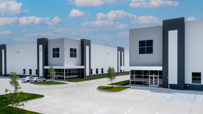
Property Record
5885 N Graham Rd E, Whiteland, IN 46184

NEARBY LISTINGS FOR SALE OR LEASE
Property Detail
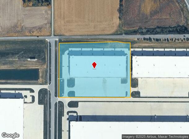
5885 N Graham Rd E
Indianapolis-Carmel-Anderson, IN
MOHR LOGISTICS PARK PHASE 1 SECTION 4 LOT 4B
41-05-23-012-002.000-028
Johnson
Heavyindustrial
Indiana
2024
4b
2025
8.50 AC
610502
Johnson County
114,852 SF
Indianapolis
DEMOGRAPHICS near 5885 N Graham Rd E
1 Mile
3 Mile
5 Mile
2024 Total Population
219
24,971
67,966
2029 Population
233
26,673
72,686
Pop Growth 2024-2029
+ 6.39%
+ 6.82%
+ 6.94%
Average Age
36
38
38
2024 Total Households
76
8,737
25,350
HH Growth 2024-2029
+ 5.26%
+ 6.96%
+ 7.13%
Median Household Inc
$79,412
$83,258
$77,785
Avg Household Size
2.90
2.80
2.60
2024 Avg HH Vehicles
2.00
2.00
2.00
Median Home Value
$210,000
$198,273
$195,979
Median Year Built
1996
1998
1996
Nearby Places
Map Layers
Map Styles
 Street
 Aerial
- Restaurants
- Banks
- Shops
- Fitness
- Groceries
PUBLIC TRANSPORTATION
AIRPORT
Indianapolis International
DRIVE
WALK
Distance
Indianapolis International
44 min
27.6 mi
Freight Ports
Port of Toledo
DRIVE
WALK
Distance
Port of Toledo
289 min
239.5 mi
SALE & LEASE HISTORY
LISTING DATE
SALE/LEASE

Mar 14, 2022
For Lease
Nearby Properties
Address
Land Use
TOTAL SIZE
Lot Size
Zoning
Address
Land Use
TOTAL SIZE
Lot Size
Zoning
1,057,350 SF
60.62 AC
Address
Land Use
TOTAL SIZE
Lot Size
Zoning
984,410 SF
73.31 AC
Address
Land Use
TOTAL SIZE
Lot Size
Zoning
845,880 SF
45.31 AC
Address
Land Use
TOTAL SIZE
Lot Size
Zoning
1,103,760 SF
84.07 AC
Address
Land Use
TOTAL SIZE
Lot Size
Zoning
997,650 SF
67.25 AC
Address
Land Use
TOTAL SIZE
Lot Size
Zoning
816,376 SF
65.10 AC
Address
Land Use
TOTAL SIZE
Lot Size
Zoning
826,800 SF
62.89 AC
Address
Land Use
TOTAL SIZE
Lot Size
Zoning
615,440 SF
78.64 AC
Address
Land Use
TOTAL SIZE
Lot Size
Zoning
34.59 AC
Address
Land Use
TOTAL SIZE
Lot Size
Zoning
588,200 SF
44.31 AC
Address
Land Use
TOTAL SIZE
Lot Size
Zoning
530,400 SF
29.63 AC
Address
Land Use
TOTAL SIZE
Lot Size
Zoning
799,575 SF
37.56 AC
Address
Land Use
TOTAL SIZE
Lot Size
Zoning
446,500 SF
45.43 AC
Address
Land Use
TOTAL SIZE
Lot Size
Zoning
581,612 SF
33.53 AC
Address
Land Use
TOTAL SIZE
Lot Size
Zoning
32.60 AC
Address
Land Use
TOTAL SIZE
Lot Size
Zoning
1,968 SF
37.45 AC
Address
Land Use
TOTAL SIZE
Lot Size
Zoning
146,716 SF
25.43 AC
Address
Land Use
TOTAL SIZE
Lot Size
Zoning
290,258 SF
21.37 AC
Address
Land Use
TOTAL SIZE
Lot Size
Zoning
56,100 SF
50.05 AC
Address
Land Use
TOTAL SIZE
Lot Size
Zoning
8.88 AC
Address
Land Use
TOTAL SIZE
Lot Size
Zoning
194,902 SF
12.44 AC
Address
Land Use
TOTAL SIZE
Lot Size
Zoning
2,008 SF
9.86 AC
Address
Land Use
TOTAL SIZE
Lot Size
Zoning
1,951 SF
26.87 AC
Address
Land Use
TOTAL SIZE
Lot Size
Zoning
178,880 SF
9.03 AC
Address
Land Use
TOTAL SIZE
Lot Size
Zoning
209,216 SF
12.88 AC
Address
Land Use
TOTAL SIZE
Lot Size
Zoning
58,711 SF
13.71 AC
Address
Land Use
TOTAL SIZE
Lot Size
Zoning
135,000 SF
13.24 AC
Address
Land Use
TOTAL SIZE
Lot Size
Zoning
168,480 SF
8.42 AC
Address
Land Use
TOTAL SIZE
Lot Size
Zoning
130,440 SF
10.05 AC
Address
Land Use
TOTAL SIZE
Lot Size
Zoning
155,000 SF
8.60 AC
The World's #1 Commercial Real Estate Marketplace
Connect with us
© 2026 CoStar Group
The information above has been obtained from sources believed reliable. While we do not doubt its accuracy we have not verified it and make no guarantee, warranty or representation about it. It is your responsibility to independently confirm its accuracy and completeness. Any projections, opinions, assumptions, or estimates used are for example only and do not represent the current or future performance of the property. The value of this transaction to you depends on tax and other factors which should be evaluated by your tax, financial, and legal advisors. You and your advisors should conduct a careful, independent investigation of the property to determine to your satisfaction the suitability of the property for your needs.