Property Record
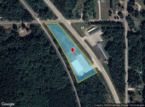
5885 N Us Highway 131 Hwy, Manton, MI 49663
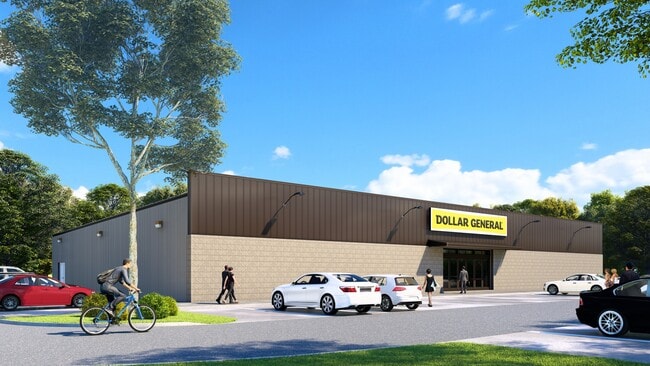
This Property Is For Sale
NEARBY LISTINGS FOR SALE OR LEASE
-
-
View all Manton listings for sale on LoopNet.com
Property Detail
5885 N Us Highway 131 Hwy
Other Market Areas
Manton
Cadillac, MI
COM AT NE COR OF SEC; S 996.5 FT; W 100.09 FT TO C/L US-131 W 78.7 FT; N'LY 451.07 FT ALG ROW TO POB: S62D55M03S W 256.44 FT
2309-04-1102
Wexford
Commercialnec
Michigan
2024
3.13 AC
2025
Michigan Northwest Area
380100
DEMOGRAPHICS near 5885 N Us Highway 131 Hwy
1 mile
3 mile
5 mile
2024 Total Population
991
2,962
4,559
2029 Population
1,015
3,035
4,676
Pop Growth 2024-2029
+ 2.42%
+ 2.46%
+ 2.57%
Average Age
38
39
39
2024 Total Households
373
1,102
1,692
HH Growth 2024-2029
+ 2.14%
+ 2.36%
+ 2.42%
Median Household Inc
$47,391
$49,402
$50,430
Avg Household Size
2.60
2.60
2.60
2024 Avg HH Vehicles
2.00
2.00
2.00
Median Home Value
$116,818
$123,615
$130,698
Median Year Built
1977
1979
1981
Nearby Places
Map Layers
Map Styles
 Street
 Aerial
Transit
 Traffic
 Biking
Places
Listings with unknown addresses are not visible on the map
- Restaurants
- Banks
- Shops
- Fitness
- Groceries
PUBLIC TRANSPORTATION
AIRPORT
Cherry Capital
Drive
Walk
Distance
Cherry Capital
53 min
33.4 mi
Freight Ports
Port Milwaukee
Drive
Walk
Distance
Port Milwaukee
416 min
370.9 mi
Nearby Properties
Address
Land Use
TOTAL SIZE
Lot Size
Zoning
Address
Land Use
TOTAL SIZE
Lot Size
Zoning
Address
Land Use
TOTAL SIZE
Lot Size
Zoning
27.43 AC
Address
Land Use
TOTAL SIZE
Lot Size
Zoning
205.48 AC
Address
Land Use
TOTAL SIZE
Lot Size
Zoning
39.24 AC
Address
Land Use
TOTAL SIZE
Lot Size
Zoning
3.49 AC
Address
Land Use
TOTAL SIZE
Lot Size
Zoning
75.28 AC
Address
Land Use
TOTAL SIZE
Lot Size
Zoning
Address
Land Use
TOTAL SIZE
Lot Size
Zoning
3.28 AC
Address
Land Use
TOTAL SIZE
Lot Size
Zoning
40 AC
Address
Land Use
TOTAL SIZE
Lot Size
Zoning
1.06 AC
Address
Land Use
TOTAL SIZE
Lot Size
Zoning
60.54 AC
Address
Land Use
TOTAL SIZE
Lot Size
Zoning
7.86 AC
Address
Land Use
TOTAL SIZE
Lot Size
Zoning
23.97 AC
Address
Land Use
TOTAL SIZE
Lot Size
Zoning
4.92 AC
Address
Land Use
TOTAL SIZE
Lot Size
Zoning
1.10 AC
Address
Land Use
TOTAL SIZE
Lot Size
Zoning
70 AC
Address
Land Use
TOTAL SIZE
Lot Size
Zoning
20 AC
Address
Land Use
TOTAL SIZE
Lot Size
Zoning
16.98 AC
Address
Land Use
TOTAL SIZE
Lot Size
Zoning
0.43 AC
Address
Land Use
TOTAL SIZE
Lot Size
Zoning
107.31 AC
Address
Land Use
TOTAL SIZE
Lot Size
Zoning
27.04 AC
Address
Land Use
TOTAL SIZE
Lot Size
Zoning
30 AC
Address
Land Use
TOTAL SIZE
Lot Size
Zoning
4.66 AC
Address
Land Use
TOTAL SIZE
Lot Size
Zoning
75.41 AC
Address
Land Use
TOTAL SIZE
Lot Size
Zoning
71.25 AC
Address
Land Use
TOTAL SIZE
Lot Size
Zoning
40 AC
Address
Land Use
TOTAL SIZE
Lot Size
Zoning
0.86 AC
Address
Land Use
TOTAL SIZE
Lot Size
Zoning
40 AC
Address
Land Use
TOTAL SIZE
Lot Size
Zoning
77.50 AC
The World's #1 Commercial Real Estate Marketplace
Connect with us
© 2026 CoStar Group
The information above has been obtained from sources believed reliable. While we do not doubt its accuracy we have not verified it and make no guarantee, warranty or representation about it. It is your responsibility to independently confirm its accuracy and completeness. Any projections, opinions, assumptions, or estimates used are for example only and do not represent the current or future performance of the property. The value of this transaction to you depends on tax and other factors which should be evaluated by your tax, financial, and legal advisors. You and your advisors should conduct a careful, independent investigation of the property to determine to your satisfaction the suitability of the property for your needs.